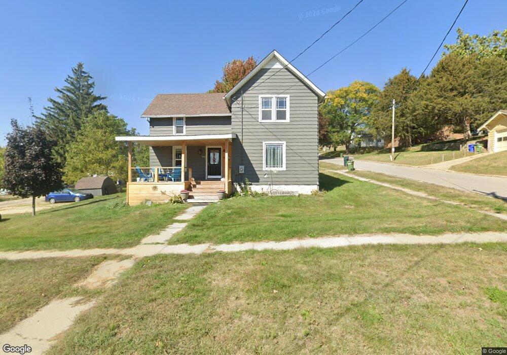
205 Plum St NE Elkader, IA 52043
Estimated Value: $99,000 - $148,000
3
Beds
1
Bath
1,534
Sq Ft
$78/Sq Ft
Est. Value
About This Home
This home is located at 205 Plum St NE, Elkader, IA 52043 and is currently estimated at $119,131, approximately $77 per square foot. 205 Plum St NE is a home located in Clayton County with nearby schools including Central Elementary School and Central Middle School/High School.
Ownership History
Date
Name
Owned For
Owner Type
Purchase Details
Closed on
Nov 23, 2015
Sold by
Metzger Lane L
Bought by
Koppes Anthony P
Current Estimated Value
Home Financials for this Owner
Home Financials are based on the most recent Mortgage that was taken out on this home.
Original Mortgage
$61,182
Outstanding Balance
$48,006
Interest Rate
3.8%
Mortgage Type
New Conventional
Estimated Equity
$71,125
Purchase Details
Closed on
Oct 9, 2006
Sold by
Handke Linda K
Bought by
Metzger Lane L
Purchase Details
Closed on
Jun 14, 2006
Sold by
Bente Kathleen R
Bought by
Handke Linda K
Create a Home Valuation Report for This Property
The Home Valuation Report is an in-depth analysis detailing your home's value as well as a comparison with similar homes in the area
Home Values in the Area
Average Home Value in this Area
Purchase History
| Date | Buyer | Sale Price | Title Company |
|---|---|---|---|
| Koppes Anthony P | $59,000 | None Available | |
| Metzger Lane L | $52,000 | None Available | |
| Handke Linda K | $50,000 | None Available |
Source: Public Records
Mortgage History
| Date | Status | Borrower | Loan Amount |
|---|---|---|---|
| Open | Koppes Anthony P | $61,182 |
Source: Public Records
Tax History Compared to Growth
Tax History
| Year | Tax Paid | Tax Assessment Tax Assessment Total Assessment is a certain percentage of the fair market value that is determined by local assessors to be the total taxable value of land and additions on the property. | Land | Improvement |
|---|---|---|---|---|
| 2025 | $1,648 | $78,560 | $13,615 | $64,945 |
| 2024 | $1,498 | $65,961 | $11,840 | $54,121 |
| 2023 | $1,358 | $65,961 | $11,840 | $54,121 |
| 2022 | $1,258 | $52,016 | $10,763 | $41,253 |
| 2021 | $946 | $52,016 | $10,763 | $41,253 |
| 2020 | $946 | $49,502 | $10,763 | $38,739 |
| 2019 | $858 | $49,502 | $10,763 | $38,739 |
| 2018 | $858 | $46,511 | $10,763 | $35,748 |
| 2017 | $888 | $46,511 | $10,763 | $35,748 |
| 2015 | $1,058 | $54,859 | $17,448 | $37,411 |
| 2014 | $1,058 | $54,859 | $17,448 | $37,411 |
Source: Public Records
Map
Nearby Homes
- 302 N 3rd St
- 117 S Main St
- 0 E Bridge St
- 301 N 1st St
- 702 N Main St
- 209 2nd St SW
- 707 N Main St
- 710 Woodland Dr NW
- 26642 Iowa 13
- 247 Franzen Ridge Rd
- 249 Franzen Ridge Rd
- 27766 Highway 13
- 0 13 Hwy Unit NBR20255145
- 27455 Harbor Rd
- 14149 Iowa 56
- 0 Grandview Rd
- TBD Country Rd
- 305 S Russell St
- TBD Birch Rd
- 108 Adams Ct