Estimated Value: $66,667 - $211,000
Studio
1
Bath
1,351
Sq Ft
$91/Sq Ft
Est. Value
About This Home
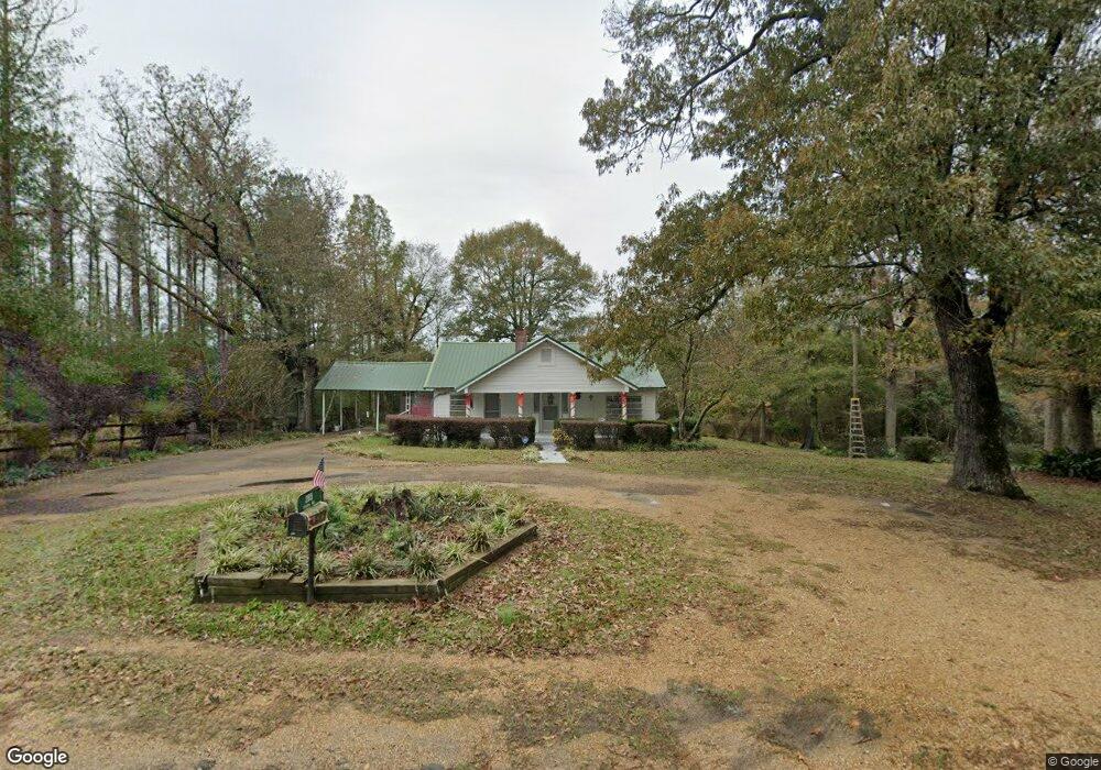
This home is located at 205 Stubbs Rd, Magee, MS 39111 and is currently estimated at $123,417, approximately $91 per square foot. 205 Stubbs Rd is a home located in Simpson County with nearby schools including Magee Elementary School, Magee Middle School, and Magee High School.
Ownership History
Date
Name
Owned For
Owner Type
Purchase Details
Closed on
Nov 15, 2024
Sold by
Stubbs James Morgan
Bought by
Green Crystal Lynn and Green Billy Joe
Current Estimated Value
Home Financials for this Owner
Home Financials are based on the most recent Mortgage that was taken out on this home.
Original Mortgage
$53,786
Interest Rate
6.12%
Mortgage Type
Construction
Purchase Details
Closed on
Mar 8, 2008
Sold by
Stubbs Minnie Jean
Bought by
Stubbs James Morgan
Create a Home Valuation Report for This Property
The Home Valuation Report is an in-depth analysis detailing your home's value as well as a comparison with similar homes in the area
Purchase History
| Date | Buyer | Sale Price | Title Company |
|---|---|---|---|
| Green Crystal Lynn | -- | None Listed On Document | |
| Green Crystal Lynn | -- | None Listed On Document | |
| Green Crystal Lynn | -- | None Listed On Document | |
| Stubbs James Morgan | -- | -- |
Source: Public Records
Mortgage History
| Date | Status | Borrower | Loan Amount |
|---|---|---|---|
| Closed | Green Crystal Lynn | $53,786 |
Source: Public Records
Tax History
| Year | Tax Paid | Tax Assessment Tax Assessment Total Assessment is a certain percentage of the fair market value that is determined by local assessors to be the total taxable value of land and additions on the property. | Land | Improvement |
|---|---|---|---|---|
| 2025 | -- | $4,093 | $0 | $0 |
| 2024 | -- | $3,486 | $0 | $0 |
| 2023 | $0 | $3,753 | $0 | $0 |
| 2022 | $0 | $3,760 | $0 | $0 |
| 2021 | $0 | $3,766 | $0 | $0 |
| 2020 | $0 | $3,453 | $0 | $0 |
| 2019 | $0 | $3,582 | $0 | $0 |
| 2018 | $0 | $3,590 | $0 | $0 |
| 2017 | $0 | $3,584 | $0 | $0 |
| 2016 | $0 | $3,549 | $0 | $0 |
| 2015 | -- | $3,534 | $0 | $0 |
| 2014 | -- | $3,521 | $0 | $0 |
Source: Public Records
Map
Nearby Homes
- 283 Simpson Highway 28 E
- 0 Dry Creek Rd Unit 4141977
- 149 John H Rd
- 1120 3rd St SE
- 1120 4th St SE
- 0 8th Ave Unit 4132915
- 702 2nd St SE
- 612 Laurel Dr SE
- 520 Choctaw St E
- 122 Hull Dr
- 334 Goshen Rd
- 429 1st Ave NE
- 210 N Jadek Dr NE
- 107 NE Adams Ave
- 227 1st St SW
- 000 Colonial Dr
- 485 Scr 62
- 212 2nd Ave SW
- 632 2nd Ave NW
- 1317 Frances Ave
- 151 Stubbs Rd
- 277 Stubbs Rd
- 104 Aline Dr
- 284 Stubbs Rd
- 128 Jim Maddox Rd
- 313 Dollar Rd
- 415 Antioch Rd
- 435 Antioch Rd
- 420 Antioch Rd
- 146 Jim Maddox Rd
- 395 Antioch Rd
- 516 Simpson Highway 28 E
- 110 Mitch Maddox Dr
- 110 Mitch Maddox Dr
- 292 Coats Rd
- 532 Simpson Highway 28 E
- 457 Antioch Rd
- 515 Simpson Highway 28 E
- 106 Aline Dr
- 257 Antioch Rd
Your Personal Tour Guide
Ask me questions while you tour the home.