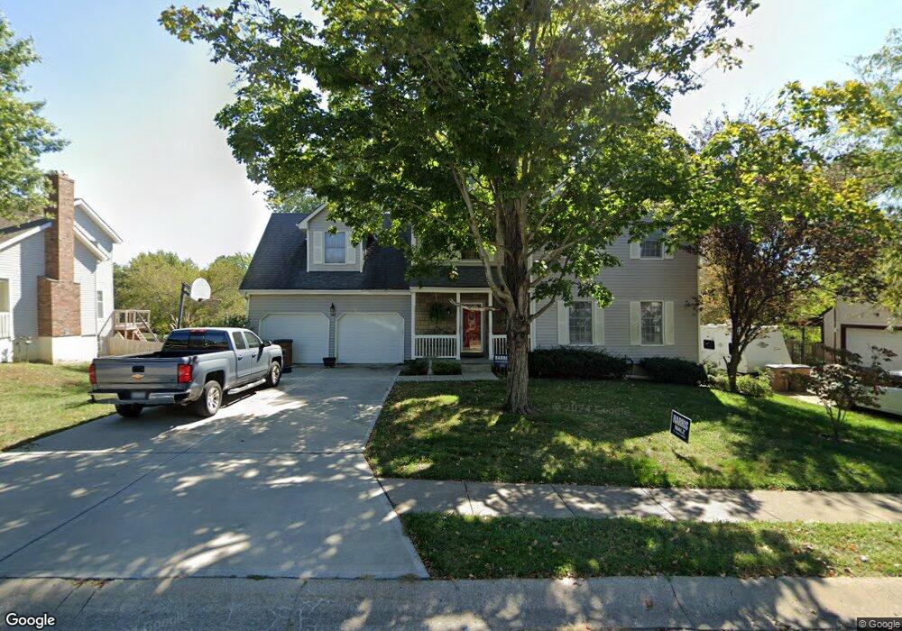
205 Toucan St Raymore, MO 64083
Estimated Value: $354,369 - $517,000
4
Beds
3
Baths
2,630
Sq Ft
$164/Sq Ft
Est. Value
About This Home
This home is located at 205 Toucan St, Raymore, MO 64083 and is currently estimated at $431,092, approximately $163 per square foot. 205 Toucan St is a home located in Cass County with nearby schools including Raymore Elementary School, Raymore-Peculiar East Middle School, and Raymore-Peculiar Senior High School.
Ownership History
Date
Name
Owned For
Owner Type
Purchase Details
Closed on
Jun 10, 2005
Sold by
Wayland Bradley A and Wayland Jene M
Bought by
Hopkins Shawn P and Hopkins Kara S
Current Estimated Value
Home Financials for this Owner
Home Financials are based on the most recent Mortgage that was taken out on this home.
Original Mortgage
$43,380
Interest Rate
5.34%
Mortgage Type
Stand Alone Second
Create a Home Valuation Report for This Property
The Home Valuation Report is an in-depth analysis detailing your home's value as well as a comparison with similar homes in the area
Home Values in the Area
Average Home Value in this Area
Purchase History
| Date | Buyer | Sale Price | Title Company |
|---|---|---|---|
| Hopkins Shawn P | -- | -- |
Source: Public Records
Mortgage History
| Date | Status | Borrower | Loan Amount |
|---|---|---|---|
| Closed | Hopkins Shawn P | $43,380 |
Source: Public Records
Tax History
| Year | Tax Paid | Tax Assessment Tax Assessment Total Assessment is a certain percentage of the fair market value that is determined by local assessors to be the total taxable value of land and additions on the property. | Land | Improvement |
|---|---|---|---|---|
| 2025 | $3,330 | $46,290 | $4,830 | $41,460 |
| 2024 | $3,330 | $40,920 | $4,390 | $36,530 |
| 2023 | $3,326 | $40,920 | $4,390 | $36,530 |
| 2022 | $2,921 | $35,710 | $4,390 | $31,320 |
| 2021 | $2,922 | $35,710 | $4,390 | $31,320 |
| 2020 | $2,870 | $34,460 | $4,390 | $30,070 |
| 2019 | $2,771 | $34,460 | $4,390 | $30,070 |
| 2018 | $2,577 | $30,950 | $3,750 | $27,200 |
| 2017 | $2,352 | $30,950 | $3,750 | $27,200 |
| 2016 | $2,352 | $29,320 | $3,750 | $25,570 |
| 2015 | $2,354 | $29,320 | $3,750 | $25,570 |
| 2014 | $2,355 | $29,320 | $3,750 | $25,570 |
| 2013 | -- | $29,320 | $3,750 | $25,570 |
Source: Public Records
Map
Nearby Homes
- 804 S Washington St
- 605 S Franklin St
- 720 Sandpiper St
- 503 S Harrison Ave
- 709 Derby St
- 528 S Saturn Dr
- 506 S Adams St
- 405 S Monroe St
- 702 Twilight Ct
- 515 S Saturn Dr
- 305 E Olive St
- 1024 S Madison St
- 522 Neptune Dr
- 211 S Franklin St
- Lot 12 Municipal Cir
- Lot 6 Municipal Cir
- Lot 13 Municipal Cir
- 600 W Buena Vista Dr
- 713 S Sunset Ln
- 814 Coventry Ln
Your Personal Tour Guide
Ask me questions while you tour the home.