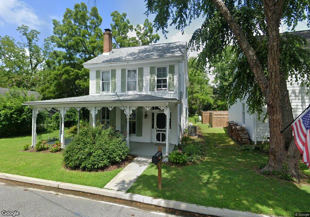
205 W Chew Ave Saint Michaels, MD 21663
Estimated Value: $707,000 - $866,287
--
Bed
1
Bath
1,616
Sq Ft
$482/Sq Ft
Est. Value
About This Home
This home is located at 205 W Chew Ave, Saint Michaels, MD 21663 and is currently estimated at $779,322, approximately $482 per square foot. 205 W Chew Ave is a home located in Talbot County with nearby schools including St. Michaels Elementary School, St. Michaels Middle/High School, and Easton High School.
Ownership History
Date
Name
Owned For
Owner Type
Purchase Details
Closed on
May 9, 2024
Sold by
Abell Stephen G and Abell Madelyn W
Bought by
Moler Patsy Wiser and Franco Carolyn L
Current Estimated Value
Purchase Details
Closed on
Mar 20, 2001
Sold by
Westervelt John J
Bought by
Abell Stephen G and Abell Madelyn W
Purchase Details
Closed on
Sep 17, 1993
Sold by
Thomas Mary F
Bought by
Westervelt John J
Home Financials for this Owner
Home Financials are based on the most recent Mortgage that was taken out on this home.
Original Mortgage
$74,000
Interest Rate
6.96%
Create a Home Valuation Report for This Property
The Home Valuation Report is an in-depth analysis detailing your home's value as well as a comparison with similar homes in the area
Home Values in the Area
Average Home Value in this Area
Purchase History
| Date | Buyer | Sale Price | Title Company |
|---|---|---|---|
| Moler Patsy Wiser | $900,000 | Eastern Shore Title | |
| Abell Stephen G | $245,000 | -- | |
| Westervelt John J | $92,500 | -- |
Source: Public Records
Mortgage History
| Date | Status | Borrower | Loan Amount |
|---|---|---|---|
| Previous Owner | Westervelt John J | $74,000 |
Source: Public Records
Tax History Compared to Growth
Tax History
| Year | Tax Paid | Tax Assessment Tax Assessment Total Assessment is a certain percentage of the fair market value that is determined by local assessors to be the total taxable value of land and additions on the property. | Land | Improvement |
|---|---|---|---|---|
| 2025 | $5,209 | $448,100 | $287,800 | $160,300 |
| 2024 | $5,209 | $421,900 | $0 | $0 |
| 2023 | $4,699 | $395,700 | $0 | $0 |
| 2022 | $4,237 | $369,500 | $244,600 | $124,900 |
| 2021 | $4,046 | $360,800 | $0 | $0 |
| 2020 | $3,999 | $352,100 | $0 | $0 |
| 2019 | $3,901 | $343,400 | $213,500 | $129,900 |
| 2018 | $3,558 | $319,033 | $0 | $0 |
| 2017 | $3,182 | $294,667 | $0 | $0 |
| 2016 | $2,601 | $270,300 | $0 | $0 |
| 2015 | $3,532 | $270,300 | $0 | $0 |
| 2014 | $3,532 | $270,300 | $0 | $0 |
Source: Public Records
Map
Nearby Homes
- 0 Grace St Unit MDTA2012346
- 100 Grace St
- 107 E Chestnut St
- 105 Seymour Ave
- 102 Gloria Ave
- 222 E Chestnut St
- 704 Meadow St
- Lot 16A Meadow St
- 216 E Chew Ave
- 807 Radcliff Ave
- 207 Dodson Ave
- 408 Spinnaker Ln
- 209 Webb Ln
- 300 Perry St
- 25500 Chance Farm Rd
- 216 Brooks Ln
- 912 Calvert Ave
- 24390 Oakwood Park Rd
- 24318 Oakwood Park Rd
- 228 Tyler Ave
- 203 W Chew Ave
- 201 W Chew Ave
- 503 Tilden St
- 200 W Chew Ave
- 117 W Chew Ave
- 115 W Chew Ave
- 207 W Chew Ave
- 114 W Chestnut St
- 120 W Chestnut St
- 208 W Chew Ave
- 116 W Chestnut St
- 118 W Chestnut St
- 114 W Chew Ave
- 112 W Chestnut St
- 113 W Chew Ave
- 122 W Chestnut St
- 112 W Chew Ave
- 110 W Chew Ave
- 0 W Chestnut St
- 602 Division St