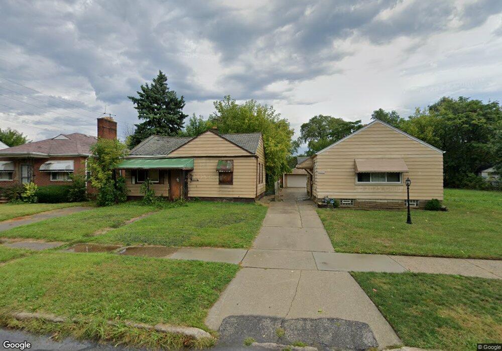
20508 Carrie St Detroit, MI 48234
Sherwood NeighborhoodEstimated Value: $47,000 - $89,925
--
Bed
1
Bath
673
Sq Ft
$97/Sq Ft
Est. Value
About This Home
This home is located at 20508 Carrie St, Detroit, MI 48234 and is currently estimated at $64,975, approximately $96 per square foot. 20508 Carrie St is a home located in Wayne County with nearby schools including Marion Law Academy, Edward 'Duke' Ellington Conservatory of Music and Art, and Charles L. Spain Elementary-Middle School.
Ownership History
Date
Name
Owned For
Owner Type
Purchase Details
Closed on
Jan 23, 2014
Sold by
Wayne County Treasurer
Bought by
Detroit Landbank Authority
Current Estimated Value
Purchase Details
Closed on
May 18, 2006
Sold by
Phoenix Real Estate Co
Bought by
Cobb Lillian
Purchase Details
Closed on
Jul 20, 2005
Sold by
The Bank Of New York
Bought by
Phoenix Real Estate
Purchase Details
Closed on
Oct 26, 2004
Sold by
Equicredit
Bought by
The Bank Of New York and Eqcc Asset Backed Certificates Series 20
Purchase Details
Closed on
Oct 13, 2004
Sold by
Schalm Kenneth and Schalm Kerin
Bought by
Equicredit
Create a Home Valuation Report for This Property
The Home Valuation Report is an in-depth analysis detailing your home's value as well as a comparison with similar homes in the area
Home Values in the Area
Average Home Value in this Area
Purchase History
| Date | Buyer | Sale Price | Title Company |
|---|---|---|---|
| Detroit Landbank Authority | -- | None Available | |
| Cobb Lillian | $67,000 | Clearly Title | |
| Phoenix Real Estate | $23,000 | Attorneys Title Agency Llc | |
| The Bank Of New York | -- | -- | |
| Equicredit | $30,973 | -- |
Source: Public Records
Tax History Compared to Growth
Tax History
| Year | Tax Paid | Tax Assessment Tax Assessment Total Assessment is a certain percentage of the fair market value that is determined by local assessors to be the total taxable value of land and additions on the property. | Land | Improvement |
|---|---|---|---|---|
| 2025 | -- | $0 | $0 | $0 |
| 2024 | -- | $0 | $0 | $0 |
| 2023 | $0 | $0 | $0 | $0 |
| 2022 | $0 | $0 | $0 | $0 |
| 2021 | $0 | $0 | $0 | $0 |
| 2020 | $1,308 | $0 | $0 | $0 |
| 2019 | $1,308 | $0 | $0 | $0 |
| 2018 | $0 | $0 | $0 | $0 |
| 2017 | -- | $0 | $0 | $0 |
| 2016 | $240 | $0 | $0 | $0 |
| 2015 | $1,091 | $0 | $0 | $0 |
| 2013 | $1,091 | $10,907 | $0 | $0 |
| 2010 | -- | $15,992 | $695 | $15,297 |
Source: Public Records
Map
Nearby Homes
- 7052 Rivard Ave
- 20485 Helen St
- 7003 Rivard Ave
- 20514 Concord St
- 20400 Packard St
- 20466 Spencer St
- 7029 Jackson Ave
- 7534 Fisher Ave
- 20185 Carrie St
- 20170 Carrie St
- 7028 Yacht Ave
- 20151 Carrie St
- 20215 Stotter St
- 20161 Helen St
- 7251 Yacht Ave
- 7645 Fisher Ave
- 7044 Westminster Ave
- 7624 Yacht Ave
- 20124 Spencer St
- 20043 Packard St
- 20500 Carrie St
- 20516 Carrie St
- 20522 Carrie St
- 20490 Carrie St
- 20530 Carrie St
- 20484 Carrie St
- 20509 Rogge St
- 20515 Rogge St
- 20501 Rogge St
- 20483 Rogge St
- 20474 Carrie St
- 20525 Rogge St
- 20491 Rogge St
- 20505 Carrie St
- 20515 Carrie St
- 20531 Rogge St
- 20495 Carrie St
- 20531 Carrie St
- 20475 Rogge St
- 20466 Carrie St