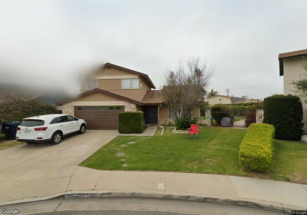
20521 Salt Air Cir Huntington Beach, CA 92646
Southeast NeighborhoodEstimated Value: $1,472,350 - $1,582,000
3
Beds
3
Baths
1,763
Sq Ft
$875/Sq Ft
Est. Value
About This Home
This home is located at 20521 Salt Air Cir, Huntington Beach, CA 92646 and is currently estimated at $1,542,838, approximately $875 per square foot. 20521 Salt Air Cir is a home located in Orange County with nearby schools including Ralph E. Hawes Elementary School, Isaac L. Sowers Middle School, and Edison High School.
Ownership History
Date
Name
Owned For
Owner Type
Purchase Details
Closed on
Nov 10, 2010
Sold by
Khaw Emily
Bought by
Khaw Emily and Emily Khaw Revocable Trust
Current Estimated Value
Purchase Details
Closed on
Sep 24, 2008
Sold by
Lindegren Karl R and Lindegren Kristen R
Bought by
Khaw Emily
Create a Home Valuation Report for This Property
The Home Valuation Report is an in-depth analysis detailing your home's value as well as a comparison with similar homes in the area
Home Values in the Area
Average Home Value in this Area
Purchase History
| Date | Buyer | Sale Price | Title Company |
|---|---|---|---|
| Khaw Emily | -- | None Available | |
| Khaw Emily | $650,000 | Landamerica Title |
Source: Public Records
Tax History Compared to Growth
Tax History
| Year | Tax Paid | Tax Assessment Tax Assessment Total Assessment is a certain percentage of the fair market value that is determined by local assessors to be the total taxable value of land and additions on the property. | Land | Improvement |
|---|---|---|---|---|
| 2025 | $9,440 | $837,037 | $707,623 | $129,414 |
| 2024 | $9,440 | $820,625 | $693,748 | $126,877 |
| 2023 | $9,229 | $804,535 | $680,145 | $124,390 |
| 2022 | $8,988 | $788,760 | $666,809 | $121,951 |
| 2021 | $8,822 | $773,295 | $653,735 | $119,560 |
| 2020 | $8,765 | $765,366 | $647,031 | $118,335 |
| 2019 | $8,661 | $750,359 | $634,344 | $116,015 |
| 2018 | $8,527 | $735,647 | $621,906 | $113,741 |
| 2017 | $8,414 | $721,223 | $609,712 | $111,511 |
| 2016 | $8,040 | $707,082 | $597,757 | $109,325 |
| 2015 | $7,964 | $696,461 | $588,778 | $107,683 |
| 2014 | $7,798 | $682,819 | $577,245 | $105,574 |
Source: Public Records
Map
Nearby Homes
- 9812 La Cresta Cir
- 20392 Redwood Ln
- 20442 Craimer Ln
- 10172 Stonybrook Dr
- 9522 Yellowstone Dr
- 21022 Manessa Cir
- 21072 Galbar Cir
- 20862 Lancelot Ln
- 9695 Adams Ave
- 19880 Berkshire Ln
- 9667 Durham Dr
- 19860 Claremont Ln
- 9745 Cornwall Dr
- 19901 Burnley Ln
- 19843 Coventry Ln
- 2741 Sandpiper Dr
- 19941 Carmania Ln
- 19854 Leighton Ln
- 9802 Effingham Dr
- 9831 Continental Dr
- 20541 Salt Air Cir
- 20522 Pebble Ln
- 20511 Salt Air Cir
- 20542 Pebble Ln
- 20512 Pebble Ln
- 20502 Salt Air Cir
- 20551 Salt Air Cir
- 20552 Pebble Ln
- 20522 Salt Air Cir
- 20512 Salt Air Cir
- 20542 Salt Air Cir
- 20561 Salt Air Cir
- 20502 Pebble Ln
- 20562 Pebble Ln
- 20552 Salt Air Cir
- 20571 Salt Air Cir
- 20562 Salt Air Cir
- 20521 Pebble Ln
- 20541 Pebble Ln
- 20511 Pebble Ln