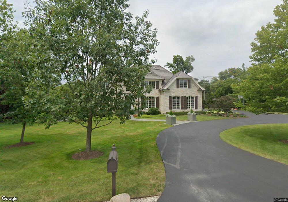
2053 Norfork Rd Northfield, IL 60093
Estimated Value: $2,263,000 - $2,709,000
6
Beds
6
Baths
5,895
Sq Ft
$431/Sq Ft
Est. Value
About This Home
This home is located at 2053 Norfork Rd, Northfield, IL 60093 and is currently estimated at $2,540,110, approximately $430 per square foot. 2053 Norfork Rd is a home located in Cook County with nearby schools including Middlefork Primary School, Sunset Ridge Elementary School, and New Trier Township High School - Northfield.
Ownership History
Date
Name
Owned For
Owner Type
Purchase Details
Closed on
Mar 10, 2017
Sold by
Burgess Gary L
Bought by
Mayberry Anka Maria
Current Estimated Value
Purchase Details
Closed on
Apr 28, 2010
Sold by
Burgess Gary L and Burgess Carrie L
Bought by
Burgess Gary L
Home Financials for this Owner
Home Financials are based on the most recent Mortgage that was taken out on this home.
Original Mortgage
$1,794,000
Interest Rate
4.5%
Mortgage Type
New Conventional
Purchase Details
Closed on
Aug 15, 2005
Sold by
2053 Norfolk Llc
Bought by
Burgess Gary L and Burgess Carrie L
Home Financials for this Owner
Home Financials are based on the most recent Mortgage that was taken out on this home.
Original Mortgage
$1,500,000
Interest Rate
4.62%
Mortgage Type
Unknown
Create a Home Valuation Report for This Property
The Home Valuation Report is an in-depth analysis detailing your home's value as well as a comparison with similar homes in the area
Home Values in the Area
Average Home Value in this Area
Purchase History
| Date | Buyer | Sale Price | Title Company |
|---|---|---|---|
| Mayberry Anka Maria | $1,625,000 | Stewart Title | |
| Burgess Gary L | -- | Titleserv Inc | |
| Burgess Gary L | $2,070,000 | Chicago Title Insurance Comp |
Source: Public Records
Mortgage History
| Date | Status | Borrower | Loan Amount |
|---|---|---|---|
| Previous Owner | Burgess Gary L | $1,794,000 | |
| Previous Owner | Burgess Gary L | $1,500,000 |
Source: Public Records
Tax History
| Year | Tax Paid | Tax Assessment Tax Assessment Total Assessment is a certain percentage of the fair market value that is determined by local assessors to be the total taxable value of land and additions on the property. | Land | Improvement |
|---|---|---|---|---|
| 2025 | $35,976 | $231,000 | $42,916 | $188,084 |
| 2024 | $35,976 | $169,987 | $35,763 | $134,224 |
| 2023 | $34,094 | $169,987 | $35,763 | $134,224 |
| 2022 | $34,094 | $169,987 | $35,763 | $134,224 |
| 2021 | $32,493 | $137,325 | $36,657 | $100,668 |
| 2020 | $31,817 | $137,325 | $36,657 | $100,668 |
| 2019 | $31,768 | $153,179 | $36,657 | $116,522 |
| 2018 | $33,226 | $152,349 | $32,186 | $120,163 |
| 2017 | $32,198 | $152,349 | $32,186 | $120,163 |
| 2016 | $33,100 | $164,830 | $32,186 | $132,644 |
| 2015 | $32,309 | $146,536 | $17,881 | $128,655 |
| 2014 | $31,691 | $146,536 | $17,881 | $128,655 |
| 2013 | $30,349 | $146,536 | $17,881 | $128,655 |
Source: Public Records
Map
Nearby Homes
- 2122 Middlefork Rd
- 898 Bridlegate Ln
- 1990 Southridge Terrace
- 590 Briar Ln
- 2154 Northgate Rd
- 513 Edens Ln
- 2185 New Willow Rd
- 4 Steeple Chase Ln
- 1930 Sunset Ridge Rd
- 265 Dickens St
- 985 Pine Tree Ln
- 831 Balmoral Ln
- 308 Happ Rd Unit 201
- 849 Country Club Ln
- 1492 Asbury Ave
- 164 Wagner Rd
- 118 Dickens Rd
- 2700 Summit Dr Unit 101
- 1423 Asbury Ave
- 1370 Sunview Ln
Your Personal Tour Guide
Ask me questions while you tour the home.