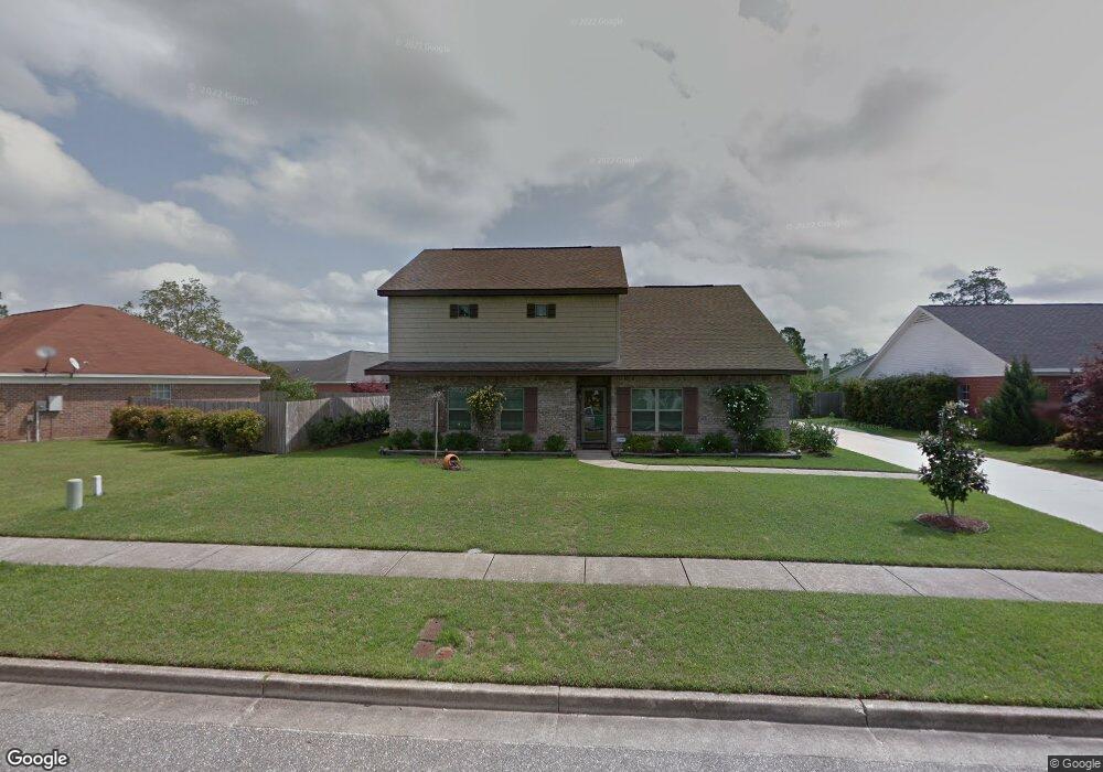
2055 E Clarke Rd Mobile, AL 36695
Yorkwood NeighborhoodEstimated Value: $313,000 - $409,000
3
Beds
2
Baths
3,110
Sq Ft
$113/Sq Ft
Est. Value
About This Home
This home is located at 2055 E Clarke Rd, Mobile, AL 36695 and is currently estimated at $352,060, approximately $113 per square foot. 2055 E Clarke Rd is a home located in Mobile County with nearby schools including O'rourke Elementary School, Bernice J Causey Middle School, and Baker High School.
Ownership History
Date
Name
Owned For
Owner Type
Purchase Details
Closed on
Oct 23, 2003
Sold by
Glisson Construction Co Inc
Bought by
Sealy William T and Sealy Glenda E
Current Estimated Value
Create a Home Valuation Report for This Property
The Home Valuation Report is an in-depth analysis detailing your home's value as well as a comparison with similar homes in the area
Home Values in the Area
Average Home Value in this Area
Purchase History
| Date | Buyer | Sale Price | Title Company |
|---|---|---|---|
| Sealy William T | -- | -- |
Source: Public Records
Tax History
| Year | Tax Paid | Tax Assessment Tax Assessment Total Assessment is a certain percentage of the fair market value that is determined by local assessors to be the total taxable value of land and additions on the property. | Land | Improvement |
|---|---|---|---|---|
| 2025 | $1,730 | $37,050 | $4,000 | $33,050 |
| 2024 | $1,672 | $35,860 | $3,900 | $31,960 |
| 2023 | $1,682 | $31,130 | $3,750 | $27,380 |
| 2022 | $1,360 | $29,410 | $3,750 | $25,660 |
| 2021 | $1,328 | $28,760 | $3,960 | $24,800 |
| 2020 | $1,337 | $28,930 | $3,600 | $25,330 |
| 2019 | $1,262 | $27,400 | $0 | $0 |
| 2018 | $1,275 | $27,660 | $0 | $0 |
| 2017 | $1,066 | $23,360 | $0 | $0 |
| 2016 | $1,077 | $23,580 | $0 | $0 |
| 2013 | $1,061 | $23,080 | $0 | $0 |
Source: Public Records
Map
Nearby Homes
- 2155 Brittany Dr
- 2200 O'Rourke Dr
- 1897 Burnham Ct
- 8690 W Anvil Ct
- 2261 Vulcan Ct
- 8400 Kendall Ct N
- 8700 Irongate Way
- 1720 Leroy Stevens Rd
- 8367 Calgary Dr S
- 2316 Leroy Stevens Rd
- 0 Walter Ct Unit 7008922
- 0 Walter Ct Unit 7008907
- 0 Walter Ct Unit 7008918
- 1645 Dawes Rd
- 8601 Cottage Hill Rd
- 8451 Placid Dr
- 8100 Danielle Dr
- 8391 Jeff Hamilton Road Extension
- 8391 Jeff Hamilton Road Extension
- 8080 Danielle Dr
- 2075 E Clarke Rd
- 2045 E Clarke Rd
- 8423 Kipling Ct
- 8413 Kipling Ct
- 8402 Milton Rd
- 8458 Rester Ct
- 8403 Kipling Ct
- 2046 E Clarke Rd
- 8392 Milton Rd
- 8449 Rester Ct
- 8411 Milton Rd
- 8394 Kipling Ct Unit 2
- 2036 E Clarke Rd
- 2025 E Clarke Rd
- 8424 Kipling Ct
- 8401 Milton Rd
- 8459 Rester Ct
- 8414 Kipling Ct
- 8382 Milton Rd
- 8468 Rester Ct
Your Personal Tour Guide
Ask me questions while you tour the home.