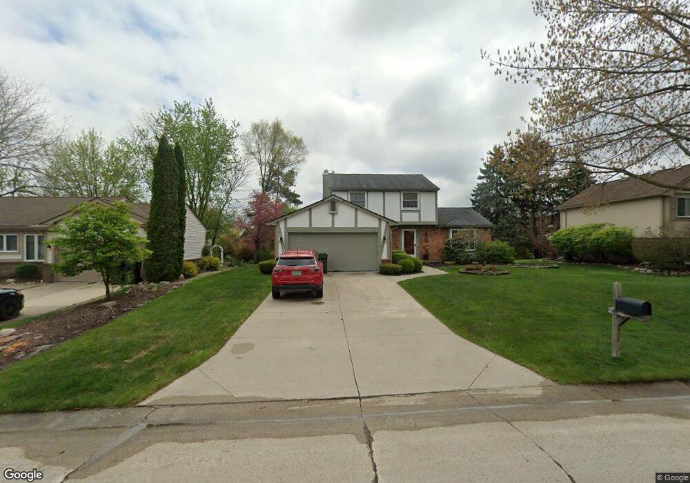
2057 Warrington Rd Rochester Hills, MI 48307
Estimated Value: $403,201 - $440,000
3
Beds
2
Baths
1,610
Sq Ft
$264/Sq Ft
Est. Value
About This Home
This home is located at 2057 Warrington Rd, Rochester Hills, MI 48307 and is currently estimated at $424,800, approximately $263 per square foot. 2057 Warrington Rd is a home located in Oakland County with nearby schools including Hamlin Elementary School, Reuther Middle School, and Rochester High School.
Ownership History
Date
Name
Owned For
Owner Type
Purchase Details
Closed on
Apr 29, 2000
Sold by
Stocke Matthew E
Bought by
Dessy Robert M
Current Estimated Value
Purchase Details
Closed on
Nov 6, 1998
Sold by
Stocke Matthew E
Bought by
Stocke Matthew E
Home Financials for this Owner
Home Financials are based on the most recent Mortgage that was taken out on this home.
Original Mortgage
$158,000
Interest Rate
7.02%
Purchase Details
Closed on
Mar 12, 1997
Sold by
Sluis Steven A
Bought by
Stocke Matthew E
Home Financials for this Owner
Home Financials are based on the most recent Mortgage that was taken out on this home.
Original Mortgage
$156,500
Interest Rate
7.82%
Create a Home Valuation Report for This Property
The Home Valuation Report is an in-depth analysis detailing your home's value as well as a comparison with similar homes in the area
Home Values in the Area
Average Home Value in this Area
Purchase History
| Date | Buyer | Sale Price | Title Company |
|---|---|---|---|
| Dessy Robert M | $207,900 | -- | |
| Stocke Matthew E | -- | -- | |
| Stocke Matthew E | $178,000 | -- |
Source: Public Records
Mortgage History
| Date | Status | Borrower | Loan Amount |
|---|---|---|---|
| Previous Owner | Stocke Matthew E | $158,000 | |
| Previous Owner | Stocke Matthew E | $156,500 |
Source: Public Records
Tax History Compared to Growth
Tax History
| Year | Tax Paid | Tax Assessment Tax Assessment Total Assessment is a certain percentage of the fair market value that is determined by local assessors to be the total taxable value of land and additions on the property. | Land | Improvement |
|---|---|---|---|---|
| 2022 | $1,607 | $139,450 | $0 | $0 |
| 2018 | $2,663 | $118,700 | $0 | $0 |
| 2017 | $2,610 | $116,150 | $0 | $0 |
| 2015 | -- | $101,020 | $0 | $0 |
| 2014 | -- | $88,950 | $0 | $0 |
| 2011 | -- | $79,020 | $0 | $0 |
Source: Public Records
Map
Nearby Homes
- 2132 Winchester Rd
- 2352 Cumberland Rd
- 00 Fieldcrest Ct
- 120 Montmorency Rd
- 2198 S Rochester Rd
- 2020 Breckenridge Ct Unit 11
- 2043 Breckenridge Ct
- 2044 Breckenridge Ct
- 2028 Breckenridge Ct Unit 10
- 2032 Breckenridge Ct Unit 9
- 700 Woodfield Way
- 1495 Colony Dr
- 1574 Meadow Side Dr Unit 199
- 1612 Stonecrest Dr
- 2691 Walbridge Rd
- 2009 Logan Dr
- 404 Meadow Bridge Dr
- 2196 Willow Leaf Dr
- 2408 S Rochester Rd
- 71 Meadow Wood Dr
- 2051 Warrington Rd
- 2063 Warrington Rd
- 574 Lockport Rd
- 550 Lockport Rd
- 2069 Warrington Rd
- 2056 Warrington Rd
- 586 Lockport Rd
- 2050 Warrington Rd
- 2064 Warrington Rd
- 2067 Highsplint Dr
- 2075 Highsplint Dr
- 2059 Highsplint Dr
- 2075 Warrington Rd
- 2083 Highsplint Dr
- 598 Lockport Rd
- 2098 Highsplint Dr
- 2051 Highsplint Dr
- 2036 Highsplint Dr
- 2081 Warrington Rd
- 567 Lockport Rd