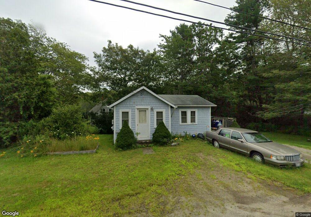
206 Back Narrows Rd Boothbay, ME 04537
Estimated Value: $179,854 - $312,000
1
Bed
1
Bath
645
Sq Ft
$370/Sq Ft
Est. Value
About This Home
This home is located at 206 Back Narrows Rd, Boothbay, ME 04537 and is currently estimated at $238,464, approximately $369 per square foot. 206 Back Narrows Rd is a home located in Lincoln County with nearby schools including Boothbay Region Elementary School and Boothbay Region High School.
Ownership History
Date
Name
Owned For
Owner Type
Purchase Details
Closed on
Sep 2, 2009
Sold by
Gatto Patricia M
Bought by
Brown Barbara E
Current Estimated Value
Home Financials for this Owner
Home Financials are based on the most recent Mortgage that was taken out on this home.
Original Mortgage
$80,000
Outstanding Balance
$51,812
Interest Rate
5%
Mortgage Type
Adjustable Rate Mortgage/ARM
Estimated Equity
$186,652
Purchase Details
Closed on
Aug 14, 2008
Sold by
Ameriquest Mtg Securities
Bought by
Gatto Patricia M
Create a Home Valuation Report for This Property
The Home Valuation Report is an in-depth analysis detailing your home's value as well as a comparison with similar homes in the area
Home Values in the Area
Average Home Value in this Area
Purchase History
| Date | Buyer | Sale Price | Title Company |
|---|---|---|---|
| Brown Barbara E | -- | -- | |
| Gatto Patricia M | -- | -- |
Source: Public Records
Mortgage History
| Date | Status | Borrower | Loan Amount |
|---|---|---|---|
| Open | Brown Barbara E | $80,000 |
Source: Public Records
Tax History Compared to Growth
Tax History
| Year | Tax Paid | Tax Assessment Tax Assessment Total Assessment is a certain percentage of the fair market value that is determined by local assessors to be the total taxable value of land and additions on the property. | Land | Improvement |
|---|---|---|---|---|
| 2024 | $1,071 | $94,352 | $35,880 | $58,472 |
| 2023 | $948 | $94,352 | $35,880 | $58,472 |
| 2022 | $877 | $94,352 | $35,880 | $58,472 |
| 2021 | $901 | $94,352 | $35,880 | $58,472 |
| 2020 | $906 | $94,352 | $35,880 | $58,472 |
| 2019 | $892 | $94,352 | $35,880 | $58,472 |
| 2018 | $877 | $94,352 | $35,880 | $58,472 |
| 2017 | $808 | $87,800 | $16,300 | $71,500 |
| 2016 | $773 | $87,800 | $16,300 | $71,500 |
| 2015 | $768 | $87,800 | $16,300 | $71,500 |
| 2014 | $746 | $87,800 | $16,300 | $71,500 |
Source: Public Records
Map
Nearby Homes
- 14 Wolf Rd
- 86 Firth Dr
- 83 Western Ledge Rd
- 105-26 Back Eighty Rd
- 28 Evergreen Dr
- 24 Marble Ledge Dr
- 25 Pineview Ridge Rd
- 98 Meadow Cove Rd
- 35 Rice Rd
- 50 Hardwick Rd
- 24 Barlow Hill Rd
- 28 & 31 Will Alley Rd
- 12 Pump Station Rd
- 494 Wiscasset Rd
- 447 Wiscasset Rd
- 239 Ocean Point Rd
- 22 School St
- 32 Murray Hill Rd
- 5 Massachusetts Ave
- 934 Wiscasset Rd
- 200 Back Narrows Rd
- 203 Back Narrows Rd
- 143 Firth Dr
- 201 Back Narrows Rd
- 214 Back Narrows Rd
- 217 Back Narrows Rd
- 198 Back Narrows Rd
- 195 Back Narrows Rd
- 190 Back Narrows Rd
- 234 Back Narrows Rd
- 186 Back Narrows Rd
- 181 Back Narrows Rd
- 229 Back Narrows Rd
- 191 Back Narrows Rd
- 182 Back Narrows Rd
- 28 Thistle Ln
- 10 Huff Rd
- 20 Huff Rd
- 176 Back Narrows Rd
- 179 Back Narrows Rd