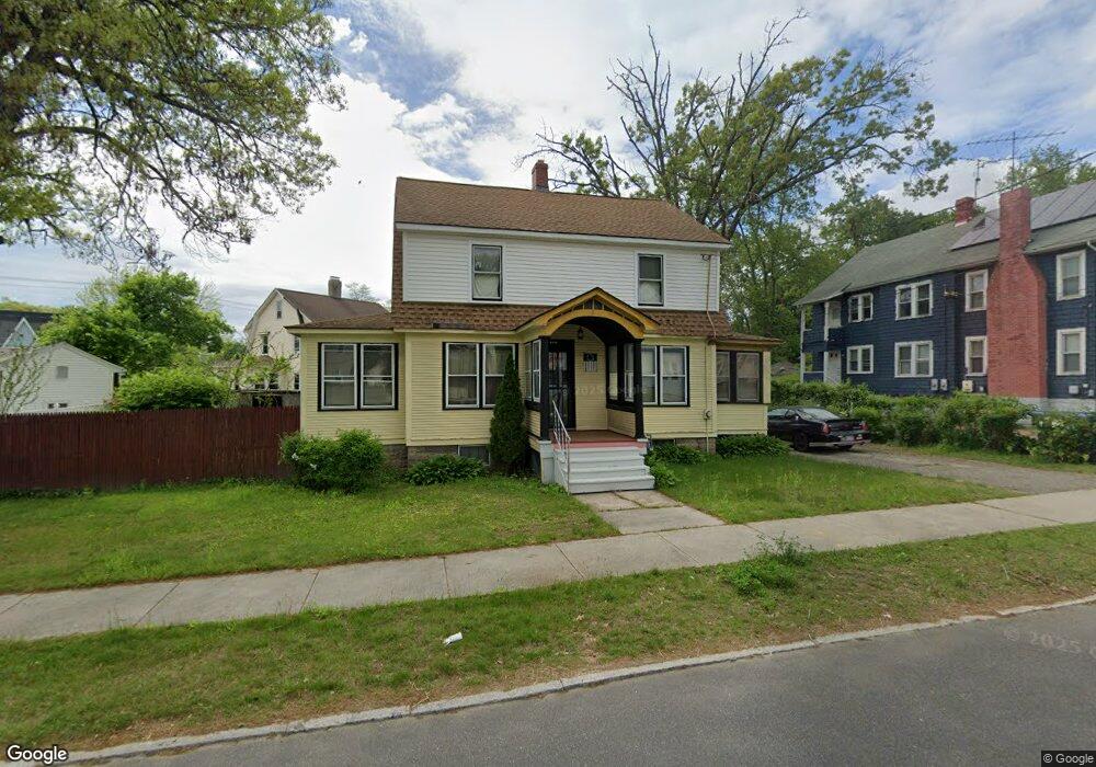
206 Bristol St Springfield, MA 01109
Upper Hill NeighborhoodEstimated Value: $241,844 - $286,000
3
Beds
1
Bath
1,636
Sq Ft
$159/Sq Ft
Est. Value
About This Home
This home is located at 206 Bristol St, Springfield, MA 01109 and is currently estimated at $260,461, approximately $159 per square foot. 206 Bristol St is a home located in Hampden County with nearby schools including Daniel B Brunton, John J Duggan Middle, and Springfield High School of Science and Technology.
Ownership History
Date
Name
Owned For
Owner Type
Purchase Details
Closed on
Apr 21, 2011
Sold by
Foote Bruce
Bought by
Springfield City Of
Current Estimated Value
Purchase Details
Closed on
Feb 10, 2011
Sold by
Foote Bruce
Bought by
Springfield City Of
Purchase Details
Closed on
Sep 11, 2009
Sold by
Foote Christopher J and Foote Daniel P
Bought by
Foote Karen A
Purchase Details
Closed on
May 15, 1972
Bought by
Foote Karen A
Create a Home Valuation Report for This Property
The Home Valuation Report is an in-depth analysis detailing your home's value as well as a comparison with similar homes in the area
Home Values in the Area
Average Home Value in this Area
Purchase History
| Date | Buyer | Sale Price | Title Company |
|---|---|---|---|
| Springfield City Of | -- | -- | |
| Springfield City Of | $321 | -- | |
| Foote Karen A | -- | -- | |
| Foote Karen A | $13,500 | -- |
Source: Public Records
Tax History
| Year | Tax Paid | Tax Assessment Tax Assessment Total Assessment is a certain percentage of the fair market value that is determined by local assessors to be the total taxable value of land and additions on the property. | Land | Improvement |
|---|---|---|---|---|
| 2025 | $2,990 | $190,700 | $31,200 | $159,500 |
| 2024 | $2,859 | $178,000 | $31,200 | $146,800 |
| 2023 | $2,607 | $152,900 | $28,400 | $124,500 |
| 2022 | $2,443 | $129,800 | $26,500 | $103,300 |
| 2021 | $2,453 | $129,800 | $18,800 | $111,000 |
| 2020 | $2,400 | $122,900 | $18,800 | $104,100 |
| 2019 | $2,454 | $124,700 | $16,000 | $108,700 |
| 2018 | $2,257 | $114,700 | $16,000 | $98,700 |
| 2017 | $2,129 | $108,300 | $15,100 | $93,200 |
| 2016 | $2,011 | $102,300 | $15,100 | $87,200 |
| 2015 | $2,042 | $103,800 | $15,100 | $88,700 |
Source: Public Records
Map
Nearby Homes
- 135-137 Suffolk St
- 124-126 Westford Cir
- 867 Roosevelt Ave
- 0 NS (24) Alden St
- 111 Marlborough St
- 62-64 Bristol St
- 11 Ina St
- 67 Villa Pkwy
- 31-33 Suffolk St
- 87 Fenwick St
- 21 Westford Cir
- 283 Wilbraham Rd
- 189 Northampton Ave
- 48-50 Dresden St
- 22 Amanda St
- 19 Westford Ave
- 44 Amanda St
- 236 Pondview Dr
- 41 Olive St
- 290 Quincy St
- 198 Bristol St Unit 200
- 199 Middlesex St
- 207 Middlesex St
- 192 Bristol St Unit 194
- 192-194 Bristol St
- 205 Bristol St
- 199 Bristol St
- 209 Bristol St
- 187 Middlesex St
- 193 Middlesex St
- 193-195 Bristol St
- 193 Bristol St Unit 195
- 188 Bristol St
- 215 Bristol St
- 189 Middlesex St
- 189 Bristol St Unit 191
- 183 Middlesex St
- 221 Bristol St
- 206 Middlesex St
- 189- Bristol St
Your Personal Tour Guide
Ask me questions while you tour the home.