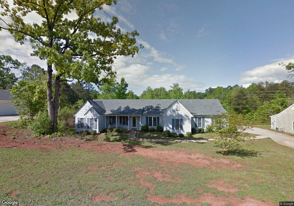
206 Dusty Dr Unit Jefferson Plantation West Union, SC 29696
Estimated Value: $179,000 - $353,000
3
Beds
3
Baths
1,650
Sq Ft
$169/Sq Ft
Est. Value
About This Home
This home is located at 206 Dusty Dr Unit Jefferson Plantation, West Union, SC 29696 and is currently estimated at $278,556, approximately $168 per square foot. 206 Dusty Dr Unit Jefferson Plantation is a home located in Oconee County with nearby schools including Walhalla Elementary School, Walhalla Middle School, and Walhalla High School.
Ownership History
Date
Name
Owned For
Owner Type
Purchase Details
Closed on
Jun 14, 2022
Sold by
Evans Melissa L
Bought by
Key Estates Llc
Current Estimated Value
Purchase Details
Closed on
Jul 17, 2008
Sold by
Agostinelli Paul W and Agostinelli Susan M
Bought by
Evans Melissa L
Home Financials for this Owner
Home Financials are based on the most recent Mortgage that was taken out on this home.
Original Mortgage
$112,000
Interest Rate
6.37%
Mortgage Type
Unknown
Create a Home Valuation Report for This Property
The Home Valuation Report is an in-depth analysis detailing your home's value as well as a comparison with similar homes in the area
Home Values in the Area
Average Home Value in this Area
Purchase History
| Date | Buyer | Sale Price | Title Company |
|---|---|---|---|
| Key Estates Llc | $155,000 | None Listed On Document | |
| Evans Melissa L | $162,000 | -- |
Source: Public Records
Mortgage History
| Date | Status | Borrower | Loan Amount |
|---|---|---|---|
| Previous Owner | Evans Melissa L | $112,000 |
Source: Public Records
Tax History Compared to Growth
Tax History
| Year | Tax Paid | Tax Assessment Tax Assessment Total Assessment is a certain percentage of the fair market value that is determined by local assessors to be the total taxable value of land and additions on the property. | Land | Improvement |
|---|---|---|---|---|
| 2025 | $2,327 | $7,219 | $721 | $6,498 |
| 2024 | $2,327 | $7,219 | $721 | $6,498 |
| 2023 | $563 | $7,219 | $721 | $6,498 |
| 2022 | $563 | $5,319 | $346 | $4,973 |
| 2021 | $563 | $5,062 | $346 | $4,716 |
| 2020 | $563 | $5,062 | $346 | $4,716 |
| 2019 | $563 | $0 | $0 | $0 |
| 2018 | $1,123 | $0 | $0 | $0 |
| 2017 | $635 | $0 | $0 | $0 |
| 2016 | $635 | $0 | $0 | $0 |
| 2015 | -- | $0 | $0 | $0 |
| 2014 | -- | $6,052 | $615 | $5,438 |
| 2013 | -- | $0 | $0 | $0 |
Source: Public Records
Map
Nearby Homes
- 146 Jefferson Rd
- 115 Burns Mill Rd
- 825 & 833 Armada Way
- 1198 Anderson St
- 141 W Waters Edge Ln
- 137 W Waters Edge Ln
- 000 Anderson St
- Lot 57 W Waters Edge Ln
- Lot 55 W Waters Edge Ln
- 173 W Waters Edge Ln
- 98 E W Waters Edge Ln
- 2539 Blue Ridge Blvd
- 450 Cedar Tree Dr
- 240 E Waters Edge Ln
- 00 Eleanore Dr
- 625 Burns Mill Rd
- 204 Friendship Dr
- 621 Burns Mill Rd
- 147 Mcalister Rd
- 213 Castlebrook Dr
- 206 Dusty Dr
- 204 Dusty Dr
- 208 Dusty Dr
- 207 Dusty Dr
- 205 Dusty Dr
- 134 Jefferson Rd
- 128 Jefferson Rd
- 136 Jefferson Rd
- 126 Jefferson Rd
- 129 Jefferson Rd
- 504 Patriot Way
- 138 Jefferson Rd
- 125 Jefferson Rd
- 512 Patriot Way
- 123 Jefferson Rd
- 124 Jefferson Rd
- 121 Jefferson Rd
- 516 Patriot Way
- 266 Dusty Dr
- 140 Jefferson Rd