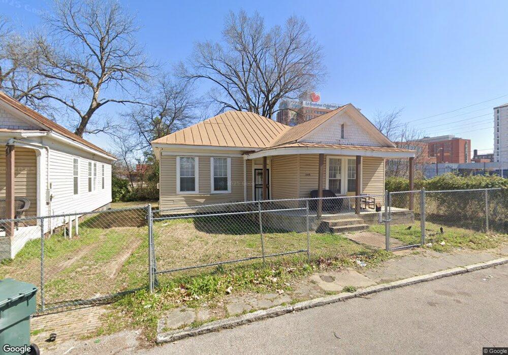
206 Leath St Memphis, TN 38105
Crosstown NeighborhoodEstimated Value: $64,000 - $102,000
3
Beds
1
Bath
1,438
Sq Ft
$62/Sq Ft
Est. Value
About This Home
This home is located at 206 Leath St, Memphis, TN 38105 and is currently estimated at $89,000, approximately $61 per square foot. 206 Leath St is a home located in Shelby County with nearby schools including Downtown Elementary School, Manassas High School, and Southwest Early College High School.
Ownership History
Date
Name
Owned For
Owner Type
Purchase Details
Closed on
May 22, 2024
Sold by
Abetew Merriweather Betelhem and Takele Abetew Betelhem
Bought by
Betelhem Abetew Living Trust and Abetew
Current Estimated Value
Purchase Details
Closed on
Aug 19, 2010
Sold by
Hsbc Bank Usa National Association
Bought by
Abetew Betelhem
Purchase Details
Closed on
May 26, 2010
Sold by
Brown Joe W
Bought by
Hsbc Bank Usa National Association
Purchase Details
Closed on
Sep 16, 2005
Sold by
Mallory Karen J
Bought by
Brown Joe W
Purchase Details
Closed on
May 30, 1996
Sold by
King Pearline B
Bought by
Belio Cedric L
Create a Home Valuation Report for This Property
The Home Valuation Report is an in-depth analysis detailing your home's value as well as a comparison with similar homes in the area
Home Values in the Area
Average Home Value in this Area
Purchase History
| Date | Buyer | Sale Price | Title Company |
|---|---|---|---|
| Betelhem Abetew Living Trust | -- | None Listed On Document | |
| Abetew Betelhem | $4,900 | Na Title Corporation | |
| Hsbc Bank Usa National Association | $17,000 | None Available | |
| Brown Joe W | $17,500 | Chicago Title Insurance Co | |
| Belio Cedric L | -- | -- |
Source: Public Records
Tax History Compared to Growth
Tax History
| Year | Tax Paid | Tax Assessment Tax Assessment Total Assessment is a certain percentage of the fair market value that is determined by local assessors to be the total taxable value of land and additions on the property. | Land | Improvement |
|---|---|---|---|---|
| 2025 | -- | $9,750 | $1,875 | $7,875 |
| 2024 | $214 | $6,300 | $750 | $5,550 |
| 2023 | $384 | $6,300 | $750 | $5,550 |
| 2022 | $384 | $6,300 | $750 | $5,550 |
| 2021 | $388 | $6,300 | $750 | $5,550 |
| 2020 | $188 | $2,600 | $750 | $1,850 |
| 2019 | $188 | $2,600 | $750 | $1,850 |
| 2018 | $188 | $2,600 | $750 | $1,850 |
| 2017 | $107 | $2,600 | $750 | $1,850 |
| 2016 | $114 | $2,600 | $0 | $0 |
| 2014 | $155 | $3,550 | $0 | $0 |
Source: Public Records
Map
Nearby Homes
- 304 N Dunlap St
- 301 N Manassas St
- 317 N Manassas St
- 0 N Orleans St
- 374 N Dunlap St
- 671 Jefferson Ave
- 236 Decatur St
- 998 J W Williams Ln
- 1086 Merriwether Ave
- 510 Leath St
- 515 N Dunlap St
- 200 N Waldran Blvd Unit 17
- 437 Monroe Ave Unit 111
- 1010 Galloway Ave
- 556 N Manassas St
- 1023 Forrest Ave
- 1060 Forrest Ave
- 930 Faxon Ave
- 230 Decatur St
- 416 N Montgomery St