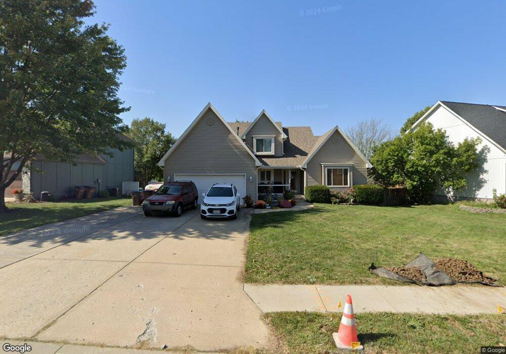
206 N Walker Dr Raymore, MO 64083
Estimated Value: $333,000 - $400,000
4
Beds
3
Baths
2,720
Sq Ft
$134/Sq Ft
Est. Value
About This Home
This home is located at 206 N Walker Dr, Raymore, MO 64083 and is currently estimated at $364,341, approximately $133 per square foot. 206 N Walker Dr is a home located in Cass County with nearby schools including Raymore Elementary School, Raymore-Peculiar East Middle School, and Raymore-Peculiar Senior High School.
Ownership History
Date
Name
Owned For
Owner Type
Purchase Details
Closed on
Dec 10, 2020
Sold by
White Martin R and White Olivia M
Bought by
White Martin R and White Olivia M
Current Estimated Value
Purchase Details
Closed on
Mar 25, 2010
Sold by
Secretary Of Hud
Bought by
White Martin R
Purchase Details
Closed on
Oct 19, 2009
Sold by
Kozeny & Mccubbin Lc
Bought by
Secretary Of Housing And Urban Developme
Purchase Details
Closed on
May 10, 2007
Sold by
Hillman Tina and Hillman Samuel Ray
Bought by
Holland George D and Holland Holly
Home Financials for this Owner
Home Financials are based on the most recent Mortgage that was taken out on this home.
Original Mortgage
$191,002
Interest Rate
6.13%
Mortgage Type
FHA
Purchase Details
Closed on
May 26, 2006
Sold by
Englebrick Jeffrey A
Bought by
Englebrick Tina M
Create a Home Valuation Report for This Property
The Home Valuation Report is an in-depth analysis detailing your home's value as well as a comparison with similar homes in the area
Home Values in the Area
Average Home Value in this Area
Purchase History
| Date | Buyer | Sale Price | Title Company |
|---|---|---|---|
| White Martin R | -- | None Available | |
| White Martin R | -- | -- | |
| Secretary Of Housing And Urban Developme | -- | None Available | |
| Holland George D | -- | -- | |
| Englebrick Tina M | -- | -- |
Source: Public Records
Mortgage History
| Date | Status | Borrower | Loan Amount |
|---|---|---|---|
| Previous Owner | Holland George D | $191,002 |
Source: Public Records
Tax History
| Year | Tax Paid | Tax Assessment Tax Assessment Total Assessment is a certain percentage of the fair market value that is determined by local assessors to be the total taxable value of land and additions on the property. | Land | Improvement |
|---|---|---|---|---|
| 2025 | $3,302 | $46,400 | $5,150 | $41,250 |
| 2024 | $3,302 | $40,630 | $4,680 | $35,950 |
| 2023 | $3,302 | $40,630 | $4,680 | $35,950 |
| 2022 | $2,979 | $36,410 | $4,680 | $31,730 |
| 2021 | $2,979 | $36,410 | $4,680 | $31,730 |
| 2020 | $2,907 | $34,900 | $4,680 | $30,220 |
| 2019 | $2,806 | $34,900 | $4,680 | $30,220 |
| 2018 | $2,586 | $31,060 | $3,820 | $27,240 |
| 2017 | $2,336 | $31,060 | $3,820 | $27,240 |
| 2016 | $2,336 | $29,120 | $3,820 | $25,300 |
| 2015 | $2,338 | $29,120 | $3,820 | $25,300 |
| 2014 | $2,339 | $29,120 | $3,820 | $25,300 |
| 2013 | -- | $29,120 | $3,820 | $25,300 |
Source: Public Records
Map
Nearby Homes
- 615 N Conway St
- 205 N Pacific Ct
- 208 N Pacific Ct
- 205 Johnston Pkwy
- 222 N Madison St
- 108 Rainbow Cir
- 105 N Landcaster Dr
- 201 Johnston Dr
- 317 & 319 W Foxwood Dr
- 600 W Buena Vista Dr
- 1105 Brookside Place
- 204 N Pointe Ln
- 701 Hampstead Dr
- 219 Pointe Ln
- 508 Foxglove Ln
- 113 N Eastglen Dr
- 416 S Jefferson St
- 703 Wood Sage Ct
- 700 Wood Sage Ct
- 701 Wood Sage Ct
- 208 N Walker Dr
- 204 N Walker Dr
- 0 N Walker Dr
- 210 N Walker Dr
- 202 N Walker Dr
- 215 N Sunset Ln
- 209 N Walker Dr
- 207 N Walker Dr
- 205 N Walker Dr
- 212 N Walker Dr
- 213 N Sunset Ln
- 211 N Walker Dr
- 203 N Walker Dr
- 200 N Walker Dr
- 614 Town Center Dr
- 214 N Walker Dr
- 211 N Sunset Ln
- 217 N Sunset Ln
- 616 Town Center Dr
- 201 N Walker Dr
Your Personal Tour Guide
Ask me questions while you tour the home.