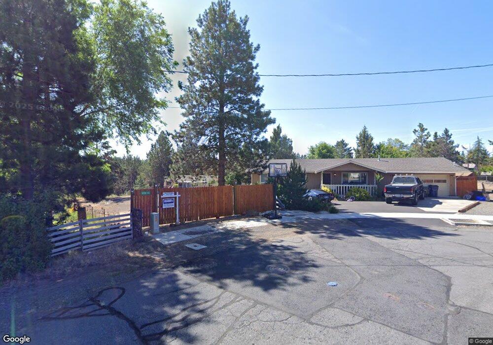
20613 Independence Way Bend, OR 97701
Boyd Acres NeighborhoodEstimated Value: $526,376 - $649,000
3
Beds
2
Baths
1,536
Sq Ft
$389/Sq Ft
Est. Value
About This Home
This home is located at 20613 Independence Way, Bend, OR 97701 and is currently estimated at $597,094, approximately $388 per square foot. 20613 Independence Way is a home located in Deschutes County with nearby schools including Lava Ridge Elementary School, Sky View Middle School, and Mountain View Senior High School.
Ownership History
Date
Name
Owned For
Owner Type
Purchase Details
Closed on
Oct 13, 2005
Sold by
Stansill Richard E and Stansill Joann M
Bought by
Parker Kenneth M and Parker Neva
Current Estimated Value
Home Financials for this Owner
Home Financials are based on the most recent Mortgage that was taken out on this home.
Original Mortgage
$193,811
Outstanding Balance
$102,252
Interest Rate
5.63%
Mortgage Type
Credit Line Revolving
Estimated Equity
$494,842
Create a Home Valuation Report for This Property
The Home Valuation Report is an in-depth analysis detailing your home's value as well as a comparison with similar homes in the area
Home Values in the Area
Average Home Value in this Area
Purchase History
| Date | Buyer | Sale Price | Title Company |
|---|---|---|---|
| Parker Kenneth M | $297,000 | Amerititle |
Source: Public Records
Mortgage History
| Date | Status | Borrower | Loan Amount |
|---|---|---|---|
| Open | Parker Kenneth M | $193,811 |
Source: Public Records
Tax History Compared to Growth
Tax History
| Year | Tax Paid | Tax Assessment Tax Assessment Total Assessment is a certain percentage of the fair market value that is determined by local assessors to be the total taxable value of land and additions on the property. | Land | Improvement |
|---|---|---|---|---|
| 2025 | $2,779 | $164,460 | -- | -- |
| 2024 | $2,673 | $159,670 | -- | -- |
| 2023 | $2,478 | $155,020 | $0 | $0 |
| 2022 | $2,312 | $146,130 | $0 | $0 |
| 2021 | $2,316 | $141,880 | $0 | $0 |
| 2020 | $2,197 | $141,880 | $0 | $0 |
| 2019 | $2,136 | $137,750 | $0 | $0 |
| 2018 | $2,076 | $133,740 | $0 | $0 |
| 2017 | $2,015 | $129,850 | $0 | $0 |
| 2016 | $1,921 | $126,070 | $0 | $0 |
| 2015 | $1,868 | $122,400 | $0 | $0 |
| 2014 | $1,813 | $118,840 | $0 | $0 |
Source: Public Records
Map
Nearby Homes
- 20629 Whitewing Ct
- 20570 Fred Meyers Rd
- 20585 Fred Meyers Rd
- 63217 Carly Ln
- 63221 Carly Ln
- 63225 Carly Ln
- 63229 NE Carly Ln
- 63233 Carly Ln
- 63249 Carly Ln
- 63210 Carly Ln
- 63218 Carly Ln
- 63222 Carly Ln
- 63226 Carly Ln
- 63230 Carly Ln
- 63238 Carly Ln
- 63246 NE Carly Ln
- 63250 NE Carly Ln
- 63254 Carly Ln
- 20676 Morningstar Dr
- Avery Plan at Acadia Pointe
- 20617 Independence Way
- 20611 Independence Way
- 20615 Independence Way
- 20618 Independence Way
- 20579 Shaniko Ln
- 63296 Vogt Rd
- 63308 Vogt
- 20582 Shaniko Ln
- 63302 Vogt Rd
- 20612 Independence Way
- 20607 Independence Way
- 63290 Vogt Rd
- 20608 Independence Way
- 20583 Shaniko Ln
- 63332 Vogt Rd
- 20590 Shaniko Ln
- 0 Independence Way
- 20599 Ficco Ct
- 20587 Shaniko Ln
- 63265 Boyd Acres Rd