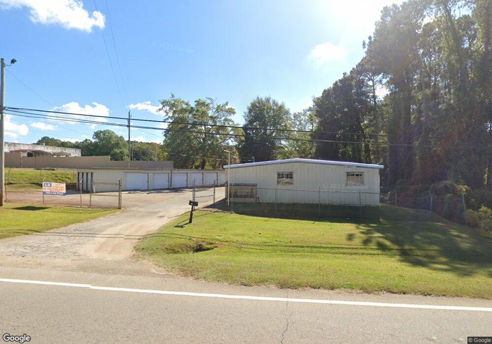
2063 W Point Rd Lagrange, GA 30240
Estimated Value: $289,472
Studio
--
Bath
3,400
Sq Ft
$85/Sq Ft
Est. Value
About This Home
This home is located at 2063 W Point Rd, Lagrange, GA 30240 and is currently priced at $289,472, approximately $85 per square foot. 2063 W Point Rd is a home located in Troup County with nearby schools including Berta Weathersbee Elementary School, Whitesville Road Elementary School, and Long Cane Elementary School.
Ownership History
Date
Name
Owned For
Owner Type
Purchase Details
Closed on
Sep 9, 2022
Sold by
Hunt Gene Allen
Bought by
Crawford Kenneth Henry Alexander and Crawford Ashley
Current Estimated Value
Home Financials for this Owner
Home Financials are based on the most recent Mortgage that was taken out on this home.
Original Mortgage
$217,164
Outstanding Balance
$195,324
Interest Rate
5.22%
Mortgage Type
Mortgage Modification
Purchase Details
Closed on
Mar 31, 2014
Sold by
Corley Vael Enterprises Ll
Bought by
Hunt David L and Hunt Gene Allen
Home Financials for this Owner
Home Financials are based on the most recent Mortgage that was taken out on this home.
Original Mortgage
$150,044
Interest Rate
4.4%
Purchase Details
Closed on
Feb 20, 2007
Sold by
Warren Randy
Bought by
Corley Vael Enterprises Llc
Purchase Details
Closed on
Feb 1, 1989
Bought by
Randy Warren and Reba White
Purchase Details
Closed on
Jan 1, 1971
Purchase Details
Closed on
Jan 1, 1970
Create a Home Valuation Report for This Property
The Home Valuation Report is an in-depth analysis detailing your home's value as well as a comparison with similar homes in the area
Purchase History
| Date | Buyer | Sale Price | Title Company |
|---|---|---|---|
| Crawford Kenneth Henry Alexander | $210,000 | -- | |
| Hunt David L | $145,000 | -- | |
| Corley Vael Enterprises Llc | -- | -- | |
| Randy Warren | -- | -- | |
| -- | -- | -- | |
| -- | -- | -- |
Source: Public Records
Mortgage History
| Date | Status | Borrower | Loan Amount |
|---|---|---|---|
| Open | Crawford Kenneth Henry Alexander | $217,164 | |
| Previous Owner | Hunt David L | $150,044 |
Source: Public Records
Tax History
| Year | Tax Paid | Tax Assessment Tax Assessment Total Assessment is a certain percentage of the fair market value that is determined by local assessors to be the total taxable value of land and additions on the property. | Land | Improvement |
|---|---|---|---|---|
| 2025 | $2,696 | $98,840 | $34,000 | $64,840 |
| 2024 | $2,696 | $98,840 | $34,000 | $64,840 |
| 2023 | $2,291 | $95,360 | $34,000 | $61,360 |
| 2022 | $2,662 | $95,360 | $34,000 | $61,360 |
| 2021 | $1,911 | $63,360 | $34,000 | $29,360 |
| 2020 | $1,911 | $63,360 | $34,000 | $29,360 |
| 2019 | $2,023 | $67,080 | $34,000 | $33,080 |
| 2018 | $2,023 | $67,080 | $34,000 | $33,080 |
| 2017 | $1,887 | $62,560 | $24,000 | $38,560 |
| 2016 | $1,980 | $65,662 | $24,000 | $41,662 |
| 2015 | $1,752 | $58,000 | $21,200 | $36,800 |
| 2014 | $1,788 | $59,104 | $24,000 | $35,104 |
| 2013 | -- | $59,104 | $24,000 | $35,104 |
Source: Public Records
Map
Nearby Homes
- 3 Reed Dr
- 0 Unit 10514554
- 101 Crown St Unit LOT 5
- 102 Crown St Unit LOT 1
- 205 Grady St
- 0 Bradfield Dr Unit 10568803
- 8 Horace Carter Rd
- 610 Wilburn Ave
- 107 Clark St
- 2239 Pegasus Pkwy
- 1520 Brownwood Ave
- 427 Fling Rd
- 211 Moores Hill
- 0 Moores Hill
- 202 Parker Ln
- 109 Garfield St
- 507 S Lee St
- 223 Pinehaven Dr
- 517 Jefferson St
- 808 S Fling Rd
- 2094 W Point Rd
- 8 Sunset Dr
- 2053 West Point Rd
- 2092 W Point Rd
- 11 Sunset Dr
- 11 Sunset Dr Unit 1
- LOT 9 Morningside Dr
- 9 Morningside Dr
- 20 Sunset Dr
- 9 Terrace Dr
- 27 Sunset Dr
- 40 Morningside Dr
- 2106 West Point Rd
- 36 Sunset Dr
- 50 Morningside Dr
- 2116 West Point Rd
- 41 Morningside Dr
- 29 Terrace Dr
- 43 Sunset Dr
- 62 Morningside Dr
Your Personal Tour Guide
Ask me questions while you tour the home.