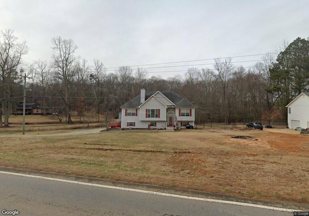
2066 Highway 101 S Temple, GA 30179
Estimated Value: $327,000 - $346,024
5
Beds
3
Baths
1,900
Sq Ft
$178/Sq Ft
Est. Value
About This Home
This home is located at 2066 Highway 101 S, Temple, GA 30179 and is currently estimated at $338,256, approximately $178 per square foot. 2066 Highway 101 S is a home located in Paulding County with nearby schools including Union Elementary School, Carl Scoggins Sr. Middle School, and South Paulding High School.
Ownership History
Date
Name
Owned For
Owner Type
Purchase Details
Closed on
Feb 23, 2018
Sold by
Crankshaw Nannie R
Bought by
Crankshaw Brett and Crankshaw Megan
Current Estimated Value
Home Financials for this Owner
Home Financials are based on the most recent Mortgage that was taken out on this home.
Original Mortgage
$137,817
Outstanding Balance
$119,436
Interest Rate
4.87%
Mortgage Type
FHA
Estimated Equity
$218,820
Purchase Details
Closed on
Mar 30, 2007
Sold by
J D Martin Builder Inc
Bought by
Crankshaw Brett A and Crankshaw Nannie R
Home Financials for this Owner
Home Financials are based on the most recent Mortgage that was taken out on this home.
Original Mortgage
$142,506
Interest Rate
6.18%
Mortgage Type
New Conventional
Create a Home Valuation Report for This Property
The Home Valuation Report is an in-depth analysis detailing your home's value as well as a comparison with similar homes in the area
Home Values in the Area
Average Home Value in this Area
Purchase History
| Date | Buyer | Sale Price | Title Company |
|---|---|---|---|
| Crankshaw Brett | -- | -- | |
| Crankshaw Brett A | $144,800 | -- |
Source: Public Records
Mortgage History
| Date | Status | Borrower | Loan Amount |
|---|---|---|---|
| Open | Crankshaw Brett | $137,817 | |
| Previous Owner | Crankshaw Brett A | $142,506 |
Source: Public Records
Tax History Compared to Growth
Tax History
| Year | Tax Paid | Tax Assessment Tax Assessment Total Assessment is a certain percentage of the fair market value that is determined by local assessors to be the total taxable value of land and additions on the property. | Land | Improvement |
|---|---|---|---|---|
| 2024 | $3,165 | $130,472 | $9,040 | $121,432 |
| 2023 | $3,168 | $124,044 | $8,600 | $115,444 |
| 2022 | $2,869 | $111,920 | $8,760 | $103,160 |
| 2021 | $2,646 | $92,900 | $6,360 | $86,540 |
| 2020 | $2,628 | $90,324 | $5,440 | $84,884 |
| 2019 | $2,388 | $81,120 | $4,720 | $76,400 |
Source: Public Records
Map
Nearby Homes
- 104 Federal Path
- 221 Pleasant Way
- 460 Pleasant Way
- 162 Faithful Dr
- 1694 Hannah Rd
- 2607 Highway 101 S
- 957 Georgia 101
- 959 Georgia 101
- 150 Charles Painter Rd
- 508 Millertown Rd
- 689 Hardin Rd
- 59 Mullberry Path
- 723 Mulberry Rock Rd
- 703 Mulberry Rock Rd
- 34 Harmony Ridge Dr
- 391 Mulberry Rock Rd
- 453 Mulberry Rock Rd
- 0 Old Draketown Trail Unit 10580748
- 728 Harmony Rd
- 0 Old Draketown Trail 5 62 Acres Unit 293 148093
- 2038 Highway 101 S
- 2075 Georgia 101
- 1996 Highway 101 S
- 2134 Highway 101 S
- 1999 Highway 101 S
- 1999 Georgia 101
- 6775 Georgia 101
- 1974 Highway 101 S Unit 6775
- 1974 Highway 101 S
- 0000 Highway 101 S
- 75 Federal Path
- 1935 Highway 101 S
- 59 Remington Path
- 1919 Georgia 101
- 86 Federal Path
- 3124 Harmony Rd
- 103 Federal Path
- 104 Remington Path
- 37 Elliott Rd
- 98 Elliott Rd