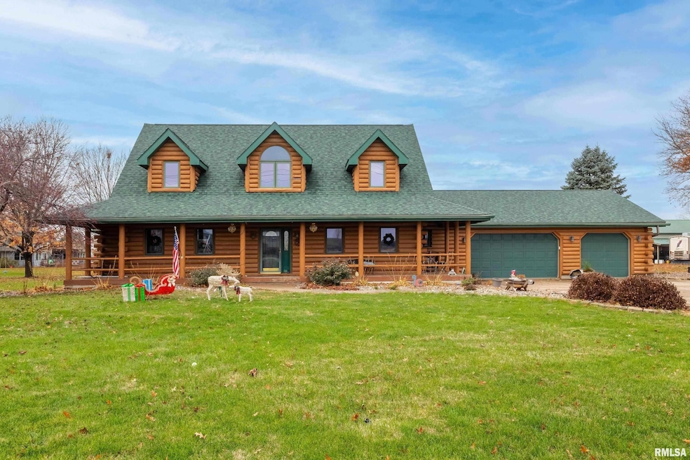
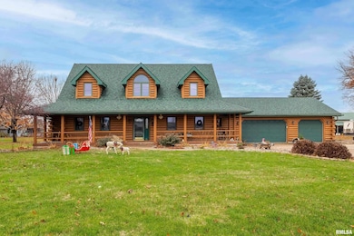


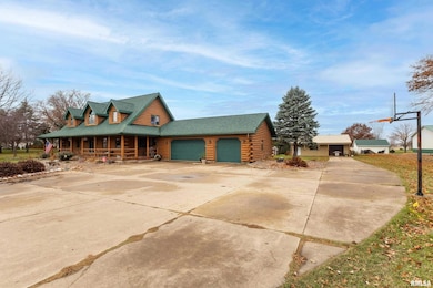

20664 N Brady St Davenport, IA 52806
Outer Davenport/Bettendorf NeighborhoodEstimated payment $3,640/month
Highlights
- Popular Property
- In Ground Pool
- Vaulted Ceiling
- Alan Shepard Elementary School Rated A-
- 1.84 Acre Lot
- Solid Surface Countertops
About This Home
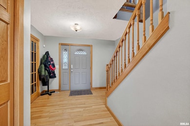
Imagine moving into this log cabin for the holidays! This 5 bedroom, 4 bathroom, 1.5 story home has over 4,000 square feet of finished living space. Upon pulling in the driveway you are welcomed by the large covered front porch. You can pull into the oversized attached garage or drive back to the 40 x 60 heated building. It’s perfect for a small business, hobbies, storing vehicles or even converted to a guest space. Currently a studio with epoxy floor, excellent lighting and lots of cabinets for storage. Between the house and garage is an inground pool with slide and power/safety cover. Enjoy the backyard that’s been landscaped when the pool was installed in 2023. In 2021, logs were resealed, and new roof in 2020. The interior is just as impressive as the exterior. Main level living space has soaring wood ceilings and huge windows that let the natural light pour in! Gorgeous stone fireplace and fresh paint and new carpet, too! Walk into the eat-in kitchen with ample cabinet and counter space. Main floor also has a laundry room and 2 sun rooms. Master suite has a large soaker tub and a walk in closet! There is an additional bedroom and full bath on the main! Upstairs there is a roomy loft and 2 more bedrooms and a newly updated full bathroom! With all this space there is still a finished walk out basement. You will find a huge bedroom with full bath, a large rec room, den and workout area. In the unfinished area there are shelves for storage and a root cellar
Listing Agent
Ruhl&Ruhl REALTORS Davenport Brokerage Phone: 563-441-1776 License #S62374000/475.159613 Listed on: 11/26/2025

Home Details
Home Type
- Single Family
Est. Annual Taxes
- $2,024
Year Built
- Built in 1995
Lot Details
- 1.84 Acre Lot
- Lot Dimensions are 260x308
- Level Lot
Parking
- 5 Car Garage
- Garage Door Opener
Home Design
- Shingle Roof
- Log Siding
Interior Spaces
- 4,524 Sq Ft Home
- Central Vacuum
- Wired For Sound
- Vaulted Ceiling
- Wood Burning Fireplace
- Fireplace With Gas Starter
- Great Room with Fireplace
- Laundry Room
Kitchen
- Range with Range Hood
- Microwave
- Dishwasher
- Solid Surface Countertops
- Disposal
Bedrooms and Bathrooms
- 5 Bedrooms
- 4 Full Bathrooms
Finished Basement
- Walk-Out Basement
- Basement Fills Entire Space Under The House
- Sump Pump
Outdoor Features
- In Ground Pool
- Enclosed Patio or Porch
Schools
- North Scott High School
Utilities
- Forced Air Heating and Cooling System
- Heating System Uses Natural Gas
- Tankless Water Heater
- Water Softener Leased
- Septic System
- High Speed Internet
- Cable TV Available
Listing and Financial Details
- Assessor Parcel Number 933523021
Map
Home Values in the Area
Average Home Value in this Area
Tax History
| Year | Tax Paid | Tax Assessment Tax Assessment Total Assessment is a certain percentage of the fair market value that is determined by local assessors to be the total taxable value of land and additions on the property. | Land | Improvement |
|---|---|---|---|---|
| 2025 | $5,844 | $593,700 | $108,000 | $485,700 |
| 2024 | $5,488 | $572,400 | $108,000 | $464,400 |
| 2023 | $5,132 | $548,600 | $108,000 | $440,600 |
| 2022 | $5,086 | $437,350 | $55,750 | $381,600 |
| 2021 | $5,086 | $437,350 | $55,750 | $381,600 |
| 2020 | $5,146 | $405,920 | $55,750 | $350,170 |
| 2019 | $5,378 | $407,550 | $55,750 | $351,800 |
| 2018 | $5,530 | $407,550 | $55,750 | $351,800 |
| 2017 | $2,267 | $407,550 | $55,750 | $351,800 |
| 2016 | $5,284 | $398,660 | $0 | $0 |
| 2015 | $5,284 | $398,660 | $0 | $0 |
| 2014 | $5,374 | $398,660 | $0 | $0 |
| 2013 | $5,306 | $0 | $0 | $0 |
| 2012 | -- | $403,320 | $55,750 | $347,570 |
Property History
| Date | Event | Price | List to Sale | Price per Sq Ft |
|---|---|---|---|---|
| 11/26/2025 11/26/25 | For Sale | $659,900 | -- | $146 / Sq Ft |
Purchase History
| Date | Type | Sale Price | Title Company |
|---|---|---|---|
| Warranty Deed | -- | -- |
Mortgage History
| Date | Status | Loan Amount | Loan Type |
|---|---|---|---|
| Open | $395,000 | VA |
Source: RMLS Alliance
MLS Number: QC4269681
APN: 933523021
Disclaimer: Certain information contained herein is derived from information provided by parties other than Homes.com. All information provided is deemed reliable, but is not guaranteed to be accurate and should be independently verified.
![]() IDX information is provided exclusively for personal, non-commercial use, and may not be used for any purpose other than to identify prospective properties consumers may be interested in purchasing. Information is deemed reliable but not guaranteed.
IDX information is provided exclusively for personal, non-commercial use, and may not be used for any purpose other than to identify prospective properties consumers may be interested in purchasing. Information is deemed reliable but not guaranteed.
- 21445 Scott Park Rd
- 1070 Olde Brandy Ln
- 6310 Deere Creek Ln
- 6322 Appomattox Rd
- LOT 54 Franklin Ave
- Lot 56 Franklin Ave
- SEQ - Division W 76th St
- 671 W 64th St
- 6308 Appomattox Rd
- 665 W 64th St
- 655 W 64th St
- 6209 Fair Ave
- 6109 N Brady St
- 6145 Fair Ave
- 6211 Deere Creek Ln
- 1572 Olde Brandy Ln
- SWQ - Division W 76th St
- Division St N & W 76th St
- Lot 26 Benjamin Ct
- 1570 Savannah Cir Unit C3
- 322 W 65th St
- 5504 Tremont Ave
- 5725 N Brady St
- 5601 Eastern Ave
- 605 W 53rd St
- 5001 Sheridan St
- 4808 Grand Ave
- 5337 Villa Dr
- 4811 Candlelight Dr
- 2625 E 56th Ct
- 4600 Grand Ave
- 4600 Grand Ave
- 641 E 46th St Unit AA3
- 643 E 46th St Unit 4600 Grand Ave B5
- 643 E 46th St Unit 6
- 2914 W 67th St
- 2700 E 53rd St
- 4826 Jersey Ridge Rd
- 2501 E 50th St Unit 5
- 5901 Elmore Ave