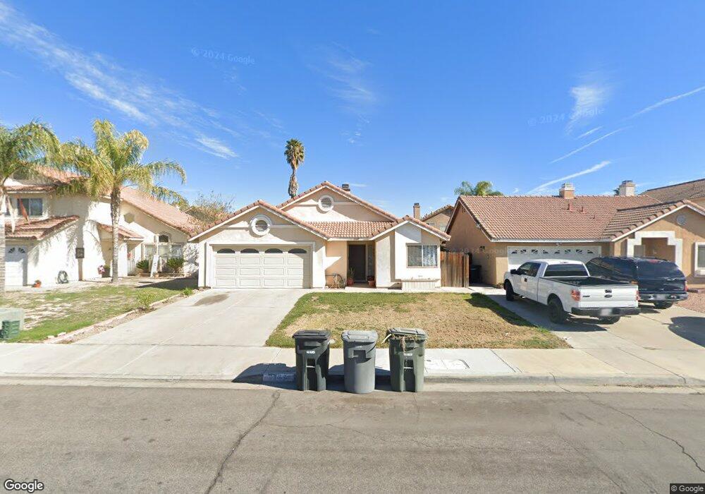
2069 Medical Center Dr Perris, CA 92571
Central Perris NeighborhoodEstimated Value: $441,000 - $456,000
3
Beds
2
Baths
1,107
Sq Ft
$405/Sq Ft
Est. Value
About This Home
This home is located at 2069 Medical Center Dr, Perris, CA 92571 and is currently estimated at $448,330, approximately $404 per square foot. 2069 Medical Center Dr is a home located in Riverside County with nearby schools including Val Verde Elementary School, Lakeside Middle School, and Rancho Verde High School.
Ownership History
Date
Name
Owned For
Owner Type
Purchase Details
Closed on
Jul 24, 1998
Sold by
Hud
Bought by
Murillo Guillermo and Murillo Josefina
Current Estimated Value
Home Financials for this Owner
Home Financials are based on the most recent Mortgage that was taken out on this home.
Original Mortgage
$67,444
Outstanding Balance
$13,718
Interest Rate
6.93%
Mortgage Type
FHA
Estimated Equity
$434,612
Purchase Details
Closed on
Nov 18, 1997
Sold by
Nationsbanc Mtg Corp
Bought by
Hud
Purchase Details
Closed on
Sep 17, 1997
Sold by
Duarte Heriberto and Duarte Frank
Bought by
Nationsbanc Mtg Corp
Create a Home Valuation Report for This Property
The Home Valuation Report is an in-depth analysis detailing your home's value as well as a comparison with similar homes in the area
Home Values in the Area
Average Home Value in this Area
Purchase History
| Date | Buyer | Sale Price | Title Company |
|---|---|---|---|
| Murillo Guillermo | $68,000 | -- | |
| Hud | -- | Fidelity National Title Ins | |
| Nationsbanc Mtg Corp | $100,048 | Old Republic Title Company |
Source: Public Records
Mortgage History
| Date | Status | Borrower | Loan Amount |
|---|---|---|---|
| Open | Murillo Guillermo | $67,444 |
Source: Public Records
Tax History Compared to Growth
Tax History
| Year | Tax Paid | Tax Assessment Tax Assessment Total Assessment is a certain percentage of the fair market value that is determined by local assessors to be the total taxable value of land and additions on the property. | Land | Improvement |
|---|---|---|---|---|
| 2025 | $1,209 | $106,574 | $39,179 | $67,395 |
| 2023 | $1,209 | $102,437 | $37,658 | $64,779 |
| 2022 | $1,172 | $100,429 | $36,920 | $63,509 |
| 2021 | $1,162 | $98,461 | $36,197 | $62,264 |
| 2020 | $1,150 | $97,452 | $35,826 | $61,626 |
| 2019 | $1,085 | $95,542 | $35,124 | $60,418 |
| 2018 | $1,069 | $93,670 | $34,437 | $59,233 |
| 2017 | $1,044 | $91,834 | $33,762 | $58,072 |
| 2016 | $1,031 | $90,034 | $33,100 | $56,934 |
| 2015 | $1,016 | $88,683 | $32,603 | $56,080 |
| 2014 | $1,003 | $86,948 | $31,965 | $54,983 |
Source: Public Records
Map
Nearby Homes
- 2245 Liberty Ct
- 302 Daystar Dr
- 2340 Firebrand Ave
- 159 Linden Ct
- 174 Linden Ct
- 2138 Star Thistle Ln
- 1864 Havasu St
- 484 Harvest Rd
- 487 Lassa Way
- 507 Coudures Way
- 2490 Cavalcade Ct
- 531 Wildwood Ln
- 575 Prairie Way
- 2363 Cloverfield St
- 1753 Jade Ave
- 1671 Ruby Dr
- 1676 Amethyst Dr
- 701 Citrus Ave
- 410 Water Ave
- 1562 Remembrance Dr
- 2073 Medical Center Dr
- 2065 Medical Center Dr
- 2068 Sundown Dr
- 2064 Sundown Dr
- 2077 Medical Center Dr
- 2072 Sundown Dr
- 2059 Medical Center Dr
- 2076 Sundown Dr
- 2064 Medical Center Dr
- 2058 Sundown Dr
- 2070 Medical Center Dr
- 2053 Medical Center Dr
- 2058 Medical Center Dr
- 209 Avocado Ave
- 2076 Medical Center Dr
- 217 Avocado Ave
- 2052 Medical Center Dr
- 2082 Medical Center Dr
- 225 Avocado Ave
- 2046 Medical Center Dr