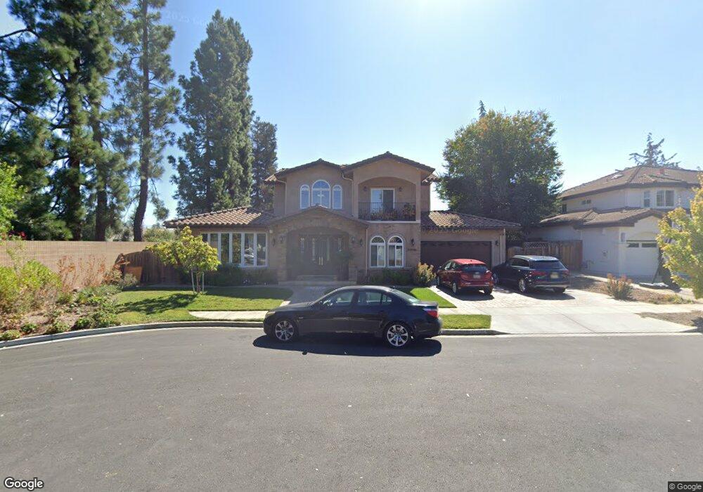
20696 Dunbar Dr Cupertino, CA 95014
North Cupertino NeighborhoodEstimated Value: $3,288,000 - $4,985,961
3
Beds
1
Bath
1,008
Sq Ft
$4,519/Sq Ft
Est. Value
About This Home
This home is located at 20696 Dunbar Dr, Cupertino, CA 95014 and is currently estimated at $4,554,990, approximately $4,518 per square foot. 20696 Dunbar Dr is a home located in Santa Clara County with nearby schools including Garden Gate Elementary School, Sam H. Lawson Middle School, and Monta Vista High School.
Ownership History
Date
Name
Owned For
Owner Type
Purchase Details
Closed on
Jun 26, 2014
Sold by
Kanukuntia Sharath and Kanukuntla Manjula
Bought by
Kanukuntla Family Revocable Trust and Kanukuntla Manjula
Current Estimated Value
Purchase Details
Closed on
Dec 1, 2011
Sold by
Wolf Barry
Bought by
Kanukuntia Sharath and Kunukuntla Manjula
Home Financials for this Owner
Home Financials are based on the most recent Mortgage that was taken out on this home.
Original Mortgage
$720,000
Outstanding Balance
$464,807
Interest Rate
2.87%
Mortgage Type
Adjustable Rate Mortgage/ARM
Estimated Equity
$4,090,183
Purchase Details
Closed on
Sep 22, 2006
Sold by
Wolf Barry and Wolf Edith
Bought by
Wolf Barry and Wolf Edith
Purchase Details
Closed on
Jan 15, 1991
Sold by
Wolf Irving Arthur and Wolf Edith
Bought by
Wolf I Arthur and Wolf Edith
Create a Home Valuation Report for This Property
The Home Valuation Report is an in-depth analysis detailing your home's value as well as a comparison with similar homes in the area
Home Values in the Area
Average Home Value in this Area
Purchase History
| Date | Buyer | Sale Price | Title Company |
|---|---|---|---|
| Kanukuntla Family Revocable Trust | -- | None Available | |
| Kanukuntia Sharath | $910,000 | Chicago Title Company | |
| Wolf Barry | -- | None Available | |
| Wolf I Arthur | -- | -- |
Source: Public Records
Mortgage History
| Date | Status | Borrower | Loan Amount |
|---|---|---|---|
| Open | Kanukuntia Sharath | $720,000 |
Source: Public Records
Tax History Compared to Growth
Tax History
| Year | Tax Paid | Tax Assessment Tax Assessment Total Assessment is a certain percentage of the fair market value that is determined by local assessors to be the total taxable value of land and additions on the property. | Land | Improvement |
|---|---|---|---|---|
| 2025 | $31,871 | $2,727,818 | $1,105,326 | $1,622,492 |
| 2024 | $31,871 | $2,674,332 | $1,083,653 | $1,590,679 |
| 2023 | $31,602 | $2,621,895 | $1,062,405 | $1,559,490 |
| 2022 | $31,165 | $2,570,486 | $1,041,574 | $1,528,912 |
| 2021 | $30,848 | $2,520,085 | $1,021,151 | $1,498,934 |
| 2020 | $30,477 | $2,494,246 | $1,010,681 | $1,483,565 |
| 2019 | $29,768 | $2,445,340 | $990,864 | $1,454,476 |
| 2018 | $29,049 | $2,397,393 | $971,436 | $1,425,957 |
| 2017 | $28,878 | $2,350,387 | $952,389 | $1,397,998 |
| 2016 | $27,969 | $2,304,302 | $933,715 | $1,370,587 |
| 2015 | $27,785 | $2,269,690 | $919,690 | $1,350,000 |
| 2014 | $14,892 | $1,198,135 | $901,675 | $296,460 |
Source: Public Records
Map
Nearby Homes
- 21035 Lauretta Dr
- 10193 Miner Place
- 20666 Celeste Cir Unit 59
- 20676 Celeste Cir Unit 71
- 10837 N Stelling Rd
- 20488 Stevens Creek Blvd Unit 2102
- 10683 Pebble Place
- 10390 N Blaney Ave
- 20128 Stevens Creek Blvd Unit 209
- 10715 Grapnel Place
- 10235 Nile Dr
- 10902 Northfield Square
- 10209 Danube Dr
- 19999 Stevens Creek Blvd Unit 209
- 10461 Mary Ave Unit 73
- 10091 Santa Clara Ave
- 20882 Cherryland Dr
- 974 Pocatello Ave
- 21091 Red Fir Ct
- 1768 Karameos Ct
- 20710 Dunbar Dr
- 20697 Fargo Dr
- 20711 Fargo Dr
- 20697 Dunbar Dr
- 20711 Dunbar Dr
- 10420 Beardon Dr
- 20670 Green Leaf Ct
- 20731 Fargo Dr
- 20731 Dunbar Dr
- 20666 Green Leaf Ct
- 20696 Greenleaf Dr
- 20696 Fargo Dr
- 20710 Greenleaf Dr
- 10470 Beardon Dr
- 20710 Fargo Dr
- 20730 Fargo Dr
- 10435 Beardon Dr
- 20730 Greenleaf Dr
- 20662 Green Leaf Ct
- 10411 Beardon Dr