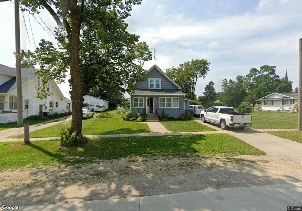
207 3rd Ave NW Waucoma, IA 52171
Estimated Value: $76,000 - $88,000
3
Beds
2
Baths
1,115
Sq Ft
$74/Sq Ft
Est. Value
About This Home
This home is located at 207 3rd Ave NW, Waucoma, IA 52171 and is currently estimated at $82,178, approximately $73 per square foot. 207 3rd Ave NW is a home located in Fayette County with nearby schools including Turkey Valley Elementary School and Turkey Valley Junior/Senior High School.
Ownership History
Date
Name
Owned For
Owner Type
Purchase Details
Closed on
Jun 27, 2022
Sold by
Chicken Jason & Kathleen
Bought by
Winter Shelbee
Current Estimated Value
Purchase Details
Closed on
Dec 1, 2016
Sold by
Franzen Diane
Bought by
Chicken Jason and Chicken Kathleen
Home Financials for this Owner
Home Financials are based on the most recent Mortgage that was taken out on this home.
Original Mortgage
$43,000
Interest Rate
3.54%
Mortgage Type
Closed End Mortgage
Create a Home Valuation Report for This Property
The Home Valuation Report is an in-depth analysis detailing your home's value as well as a comparison with similar homes in the area
Purchase History
| Date | Buyer | Sale Price | Title Company |
|---|---|---|---|
| Winter Shelbee | $65,400 | None Listed On Document | |
| Chicken Jason | -- | None Available |
Source: Public Records
Mortgage History
| Date | Status | Borrower | Loan Amount |
|---|---|---|---|
| Previous Owner | Chicken Jason | $43,000 |
Source: Public Records
Tax History
| Year | Tax Paid | Tax Assessment Tax Assessment Total Assessment is a certain percentage of the fair market value that is determined by local assessors to be the total taxable value of land and additions on the property. | Land | Improvement |
|---|---|---|---|---|
| 2025 | $934 | $78,100 | $6,780 | $71,320 |
| 2024 | $934 | $68,190 | $6,780 | $61,410 |
| 2023 | $490 | $68,190 | $6,780 | $61,410 |
| 2022 | $454 | $38,720 | $5,650 | $33,070 |
| 2021 | $454 | $38,720 | $5,650 | $33,070 |
| 2020 | $562 | $44,770 | $2,470 | $42,300 |
| 2019 | $472 | $37,270 | $0 | $0 |
| 2018 | $456 | $37,270 | $0 | $0 |
| 2017 | $624 | $35,430 | $0 | $0 |
| 2016 | $630 | $35,430 | $0 | $0 |
| 2015 | $630 | $0 | $0 | $0 |
| 2014 | $622 | $0 | $0 | $0 |
Source: Public Records
Map
Nearby Homes
- 3355 220th St
- 115 S Main St
- 306 N Brush St
- 2240 Roanoke Ave
- 0 Unit NBR20260667
- 213 W Main St
- 2584 Wild Rose Rd
- 1882 Timber Rd
- Lot 3 Schult Ridge & Lions Rd
- Lot 2 Schult Ridge & Lions Rd
- Lot 4 Schult Ridge & Lions Rd
- Lot 1 Schult Ridge & Lions Rd
- Lot 5 Schult Ridge & Lions Rd
- Lot 6 Schult Ridge & Lions Rd
- 402 S Washington Ave
- 119 Pearl St
- 0 Old Borax Rd Unit NBR20255211
- 3074 Union Ave
- 15453 200th St
- 302 S West St
Your Personal Tour Guide
Ask me questions while you tour the home.