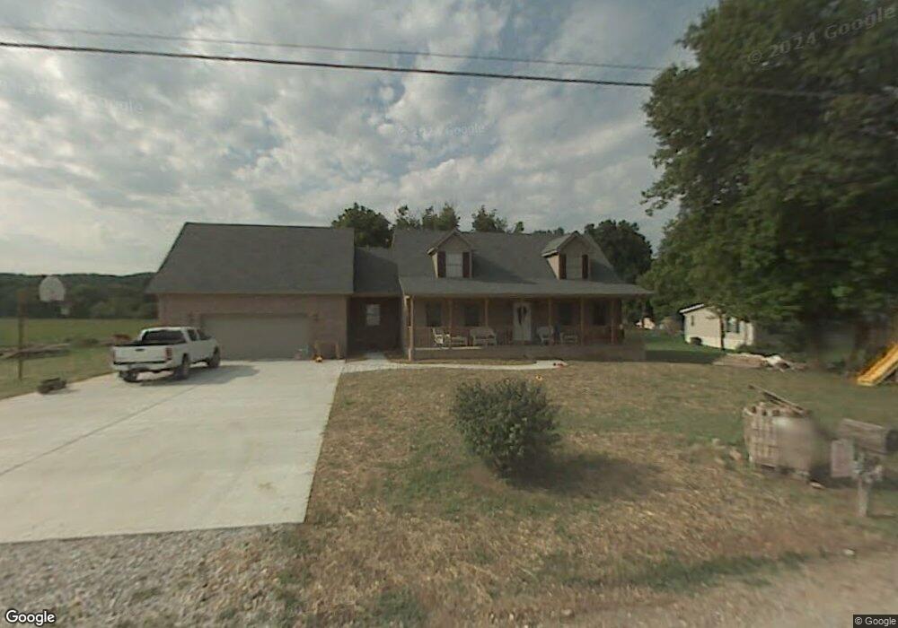
207 Camp Rd Saint Albans, WV 25177
Estimated Value: $186,000 - $383,000
3
Beds
3
Baths
2,380
Sq Ft
$117/Sq Ft
Est. Value
About This Home
This home is located at 207 Camp Rd, Saint Albans, WV 25177 and is currently estimated at $277,921, approximately $116 per square foot. 207 Camp Rd is a home located in Kanawha County with nearby schools including Lakewood Elementary School, Hayes Middle School, and Saint Albans High School.
Ownership History
Date
Name
Owned For
Owner Type
Purchase Details
Closed on
Jul 6, 2006
Sold by
Bryan Jackie L
Bought by
Payne Thomas E
Current Estimated Value
Home Financials for this Owner
Home Financials are based on the most recent Mortgage that was taken out on this home.
Original Mortgage
$145,000
Outstanding Balance
$85,458
Interest Rate
6.71%
Mortgage Type
Construction
Estimated Equity
$192,463
Create a Home Valuation Report for This Property
The Home Valuation Report is an in-depth analysis detailing your home's value as well as a comparison with similar homes in the area
Home Values in the Area
Average Home Value in this Area
Purchase History
| Date | Buyer | Sale Price | Title Company |
|---|---|---|---|
| Payne Thomas E | $30,000 | -- |
Source: Public Records
Mortgage History
| Date | Status | Borrower | Loan Amount |
|---|---|---|---|
| Open | Payne Thomas E | $145,000 |
Source: Public Records
Tax History Compared to Growth
Tax History
| Year | Tax Paid | Tax Assessment Tax Assessment Total Assessment is a certain percentage of the fair market value that is determined by local assessors to be the total taxable value of land and additions on the property. | Land | Improvement |
|---|---|---|---|---|
| 2025 | $1,550 | $123,060 | $12,720 | $110,340 |
| 2024 | $1,550 | $125,340 | $12,060 | $113,280 |
| 2023 | $1,519 | $120,540 | $12,060 | $108,480 |
| 2022 | $1,536 | $121,920 | $12,060 | $109,860 |
| 2021 | $1,554 | $123,360 | $12,060 | $111,300 |
| 2020 | $1,571 | $124,680 | $12,060 | $112,620 |
| 2019 | $1,589 | $126,120 | $12,060 | $114,060 |
| 2018 | $1,429 | $127,560 | $12,060 | $115,500 |
| 2017 | $1,331 | $118,560 | $12,060 | $106,500 |
| 2016 | $1,348 | $119,880 | $12,060 | $107,820 |
| 2015 | $1,360 | $121,080 | $12,060 | $109,020 |
| 2014 | $1,333 | $120,780 | $12,060 | $108,720 |
Source: Public Records
Map
Nearby Homes
- 1514 Strawberry Rd
- 8 Cobblestone Ln
- 20 Bellwood Dr
- 2518 E Parkview Dr
- 101 Whitetail Ln
- 713 High St
- 418 Donna Dr
- 2102 Lith Blvd
- 11500 Coal River Rd
- 12240 Coal River Rd
- 414 Lore St
- 418 Kanawha St
- 2102 Woodhill Place
- 336 Birch St
- 67 Central Ave
- 48 Lee Dr
- 69 Central Ave
- 209 Stuart St
- 211 Stuart St
- 200 Strawberry Rd
- 205 Camp Rd
- 206 Camp Rd
- 204 Camp Rd
- 4011 Lower Falls Rd
- 4025 Lower Falls Rd
- 201 Camp Rd
- 160 Bryan Ave
- 204 Bryan Ave
- 0 Lower Falls Rd
- 3025 Lower Falls Rd
- 4038 Lower Falls Rd
- 205 Bryan Ave
- 227 Bryan Ave
- 207 Bryan Ave
- 209 Bryan Ave
- 211 Bryan Ave
- 146 Bryan Ave
- 213 Bryan Ave
- 3025 Shadyside Rd
- 217 Bryan Ave