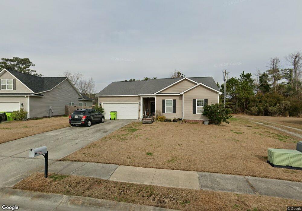
207 Channel Marker Loop Swansboro, NC 28584
Estimated Value: $177,000 - $320,000
3
Beds
4
Baths
1,252
Sq Ft
$220/Sq Ft
Est. Value
About This Home
This home is located at 207 Channel Marker Loop, Swansboro, NC 28584 and is currently estimated at $275,454, approximately $220 per square foot. 207 Channel Marker Loop is a home with nearby schools including Swansboro Elementary School, Swansboro Middle School, and Swansboro High School.
Ownership History
Date
Name
Owned For
Owner Type
Purchase Details
Closed on
Apr 19, 2012
Sold by
Swannsborough Acres Llc
Bought by
Sherman Dequence C
Current Estimated Value
Home Financials for this Owner
Home Financials are based on the most recent Mortgage that was taken out on this home.
Original Mortgage
$132,284
Outstanding Balance
$91,327
Interest Rate
3.9%
Mortgage Type
VA
Estimated Equity
$184,127
Create a Home Valuation Report for This Property
The Home Valuation Report is an in-depth analysis detailing your home's value as well as a comparison with similar homes in the area
Home Values in the Area
Average Home Value in this Area
Purchase History
| Date | Buyer | Sale Price | Title Company |
|---|---|---|---|
| Sherman Dequence C | $129,500 | None Available |
Source: Public Records
Mortgage History
| Date | Status | Borrower | Loan Amount |
|---|---|---|---|
| Open | Sherman Dequence C | $132,284 |
Source: Public Records
Tax History
| Year | Tax Paid | Tax Assessment Tax Assessment Total Assessment is a certain percentage of the fair market value that is determined by local assessors to be the total taxable value of land and additions on the property. | Land | Improvement |
|---|---|---|---|---|
| 2025 | $1,999 | $198,865 | $45,000 | $153,865 |
| 2024 | $1,999 | $198,865 | $45,000 | $153,865 |
| 2023 | $1,999 | $198,865 | $45,000 | $153,865 |
| 2022 | $1,999 | $198,865 | $45,000 | $153,865 |
| 2021 | $1,602 | $151,830 | $36,000 | $115,830 |
| 2020 | $1,602 | $151,830 | $36,000 | $115,830 |
| 2019 | $1,602 | $151,830 | $36,000 | $115,830 |
| 2018 | $1,602 | $151,830 | $36,000 | $115,830 |
| 2017 | $1,555 | $151,740 | $38,000 | $113,740 |
| 2016 | $1,555 | $151,740 | $0 | $0 |
| 2015 | $1,555 | $151,740 | $0 | $0 |
| 2014 | $1,555 | $151,740 | $0 | $0 |
Source: Public Records
Map
Nearby Homes
- 109 Borough Nest Dr
- 224 Channel Marker Loop
- 226 Channel Marker Loop
- 110 Hidden Creek Dr
- 111 Hidden Creek Dr
- 274 Norris Rd
- 161 Howard Ln
- 112 Walnut Dr
- 30 Outrigger Dr
- 1223 W Corbett Ave
- 4 Catalina Cir
- 1476 W Corbett Ave
- 109 Forest Ln
- 140 Plantation Dr
- 195 Queens Creek Rd
- 1261 Hammocks Beach Rd
- Lot 14 Hammocks Beach Rd
- 1229 Hammock Beach Rd
- 410 Holly Ln
- 119 Tundra Trail
- 205 Channel Marker Loop
- 209 Channel Marker Loop
- 203 Channel Marker Loop
- 204 Channel Marker Loop
- 202 Channel Marker Loop
- 226 Norris Rd
- 230 Norris Rd
- 206 Channel Marker Loop
- 200 Channel Marker Loop
- 201 Channel Marker Loop
- 302 Buoy Ct
- 105 Borough Nest Dr
- 208 Channel Marker Loop
- 300 Bouy Ct
- 211 Channel Marker Loop
- 232 Norris Rd
- 107 Borough Nest Dr
- 106 Borough Nest Dr
- 210 Channel Marker Loop
- 104 Borough Nest Dr
Your Personal Tour Guide
Ask me questions while you tour the home.