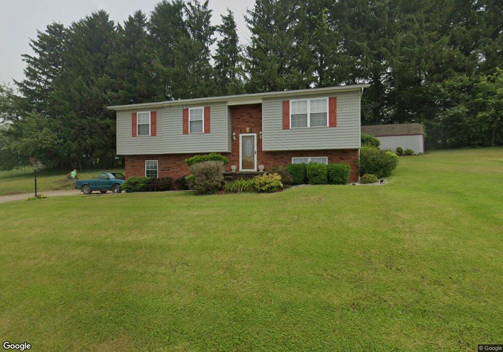
207 McGhee Dr Barnesville, OH 43713
Estimated Value: $178,000 - $254,000
3
Beds
2
Baths
1,220
Sq Ft
$175/Sq Ft
Est. Value
About This Home
This home is located at 207 McGhee Dr, Barnesville, OH 43713 and is currently estimated at $213,176, approximately $174 per square foot. 207 McGhee Dr is a home located in Belmont County with nearby schools including Barnesville Elementary School, Barnesville Middle School, and Barnesville High School.
Ownership History
Date
Name
Owned For
Owner Type
Purchase Details
Closed on
Nov 15, 2000
Sold by
Carpenter Thomas A
Bought by
Carpenter Thomas A
Current Estimated Value
Purchase Details
Closed on
Jan 3, 2000
Sold by
Byler John A and Byler Alan A
Bought by
Byler John A and Byler Alan A
Purchase Details
Closed on
Jun 23, 1998
Sold by
Jung Herbert and Surv Mary
Bought by
Jung Herbert and Mary Surv
Purchase Details
Closed on
Oct 23, 1996
Sold by
Moore James T and Jo Mary
Bought by
Moore James T and Mary Jo
Purchase Details
Closed on
Jan 1, 1986
Sold by
Moore James T and Jo Mary
Bought by
Moore James T and Mary Jo
Create a Home Valuation Report for This Property
The Home Valuation Report is an in-depth analysis detailing your home's value as well as a comparison with similar homes in the area
Home Values in the Area
Average Home Value in this Area
Purchase History
| Date | Buyer | Sale Price | Title Company |
|---|---|---|---|
| Carpenter Thomas A | $99,900 | -- | |
| Byler John A | $11,800 | -- | |
| Jung Herbert | $12,500 | -- | |
| Moore James T | -- | -- | |
| Moore James T | -- | -- |
Source: Public Records
Tax History
| Year | Tax Paid | Tax Assessment Tax Assessment Total Assessment is a certain percentage of the fair market value that is determined by local assessors to be the total taxable value of land and additions on the property. | Land | Improvement |
|---|---|---|---|---|
| 2025 | $1,767 | $64,020 | $6,140 | $57,880 |
| 2024 | $1,812 | $65,870 | $6,140 | $59,730 |
| 2023 | $1,311 | $48,030 | $5,100 | $42,930 |
| 2022 | $1,324 | $48,037 | $5,103 | $42,934 |
| 2021 | $1,327 | $48,037 | $5,103 | $42,934 |
| 2020 | $1,105 | $40,030 | $4,250 | $35,780 |
| 2019 | $1,108 | $40,030 | $4,250 | $35,780 |
| 2018 | $1,106 | $40,030 | $4,250 | $35,780 |
| 2017 | $997 | $36,430 | $5,260 | $31,170 |
| 2016 | $934 | $36,430 | $5,260 | $31,170 |
| 2015 | $1,475 | $52,770 | $5,260 | $47,510 |
| 2014 | $1,477 | $43,720 | $4,780 | $38,940 |
| 2013 | $1,492 | $43,720 | $4,780 | $38,940 |
Source: Public Records
Map
Nearby Homes
- 329 S Chestnut St
- 152 E Main St
- 613 E Main St
- 164 Pine Ln
- 136 E Walnut St
- 118 Pine Ln
- 724 E Main St
- 0 Fairmont Ave Unit 5163774
- 0 Fairmont Ave Unit 5163784
- 202 Walton Ave
- 617 Park St
- 618 Park St
- TBD W Main St
- 62239 Hillcrest Rd
- 0 County Road 114
- 57128 Somerton Hwy
- 0 Nevada Rd
- Lot 1 Cattle Dr
- 63054 & 63060 S 26 Rd
- 101 Willow St
- 208 McGhee Dr
- 210 McGhee Dr
- 104 Shady Ln
- 204 McGee Ln
- 203 McGhee Dr
- 106 Shady Ln
- 105 Shady Ln
- 202 McGhee Dr
- 212 Mc Ghee Dr
- 201 Shady Ln
- 103 Shady Ln
- 217 McGhee Dr
- 101 Shady Ln
- 100 McGhee Dr
- 94 Shady Ln
- 435 S Lincoln Ave Unit G2
- 435 S Lincoln Ave Unit A-G
- 435 S Lincoln Ave
- 435 S Lincoln Ave Unit F6
- 435 S Lincoln Ave
Your Personal Tour Guide
Ask me questions while you tour the home.