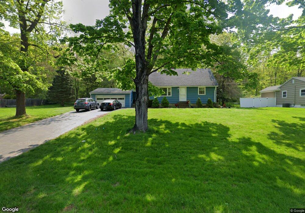
207 Stevenson Rd Fairfield, CT 06825
Estimated Value: $538,423 - $624,000
4
Beds
1
Bath
1,135
Sq Ft
$511/Sq Ft
Est. Value
About This Home
This home is located at 207 Stevenson Rd, Fairfield, CT 06825 and is currently estimated at $579,606, approximately $510 per square foot. 207 Stevenson Rd is a home located in Fairfield County with nearby schools including North Stratfield Elementary School, Fairfield Woods Middle School, and Fairfield Warde High School.
Ownership History
Date
Name
Owned For
Owner Type
Purchase Details
Closed on
Dec 9, 2009
Sold by
Laughter Ruby M
Bought by
Santini Brian M
Current Estimated Value
Home Financials for this Owner
Home Financials are based on the most recent Mortgage that was taken out on this home.
Original Mortgage
$264,000
Interest Rate
4.78%
Purchase Details
Closed on
Sep 16, 2009
Sold by
Santini Brian M and Laughter Ruby M
Bought by
Santini Brian M and Laughter Ruby M
Purchase Details
Closed on
Jan 21, 2009
Sold by
Mayers Roger S and Mayers Christine A
Bought by
Santini Brian M and Laughter Ruby M
Purchase Details
Closed on
Mar 27, 1997
Sold by
Poltrack Betty J
Bought by
Mayers Roger S and Mayers Christine A
Create a Home Valuation Report for This Property
The Home Valuation Report is an in-depth analysis detailing your home's value as well as a comparison with similar homes in the area
Home Values in the Area
Average Home Value in this Area
Purchase History
| Date | Buyer | Sale Price | Title Company |
|---|---|---|---|
| Santini Brian M | $15,000 | -- | |
| Santini Brian M | $15,000 | -- | |
| Santini Brian M | -- | -- | |
| Santini Brian M | -- | -- | |
| Santini Brian M | $330,000 | -- | |
| Santini Brian M | $330,000 | -- | |
| Mayers Roger S | $172,000 | -- | |
| Mayers Roger S | $172,000 | -- |
Source: Public Records
Mortgage History
| Date | Status | Borrower | Loan Amount |
|---|---|---|---|
| Open | Mayers Roger S | $256,000 | |
| Closed | Mayers Roger S | $264,000 |
Source: Public Records
Tax History Compared to Growth
Tax History
| Year | Tax Paid | Tax Assessment Tax Assessment Total Assessment is a certain percentage of the fair market value that is determined by local assessors to be the total taxable value of land and additions on the property. | Land | Improvement |
|---|---|---|---|---|
| 2025 | $5,727 | $201,740 | $143,360 | $58,380 |
| 2024 | $5,629 | $201,740 | $143,360 | $58,380 |
| 2023 | $5,550 | $201,740 | $143,360 | $58,380 |
| 2022 | $5,495 | $201,740 | $143,360 | $58,380 |
| 2021 | $5,755 | $201,740 | $143,360 | $58,380 |
| 2020 | $6,826 | $254,800 | $191,170 | $63,630 |
| 2019 | $6,826 | $254,800 | $191,170 | $63,630 |
| 2018 | $6,717 | $254,800 | $191,170 | $63,630 |
| 2017 | $60,823 | $254,800 | $191,170 | $63,630 |
| 2016 | $6,485 | $254,800 | $191,170 | $63,630 |
| 2015 | $6,238 | $251,650 | $192,150 | $59,500 |
| 2014 | $6,140 | $251,650 | $192,150 | $59,500 |
Source: Public Records
Map
Nearby Homes
- 26 Wendy Rd
- 42 Wendy Rd
- 18 Ridgebury Dr
- 93 Tersana Dr
- 76 Hilary Cir Unit 76
- 121 Richfield Rd
- 81 Lance Cir
- 44 Lance Cir Unit 44
- lot 194 Prospect Ave
- 35 Sturbridge Rd
- 38 Chester Rd
- 66 Loftus Cir
- 68 High Ridge Rd
- 4293 Madison Ave
- 71 Schiller Rd
- 65 Dobson St
- 64 Dobson St
- 16 Manor Ln
- 28 Hillside Dr
- 83 Buck Hill Rd
- 179 Stevenson Rd
- 218 Stevenson Rd
- 196 Stevenson Rd
- 235 Stevenson Rd
- 236 Stevenson Rd
- 257 Stevenson Rd
- 145 Stevenson Rd
- 258 Stevenson Rd
- 273 Toll House Ln
- 309 Toll House Ln
- 279 Stevenson Rd
- 123 Stevenson Rd
- 286 Stevenson Rd
- 249 Toll House Ln
- 331 Toll House Ln
- 231 Toll House Ln
- 291 Toll House Ln
- 101 Stevenson Rd
- 351 Toll House Ln
- 299 Stevenson Rd