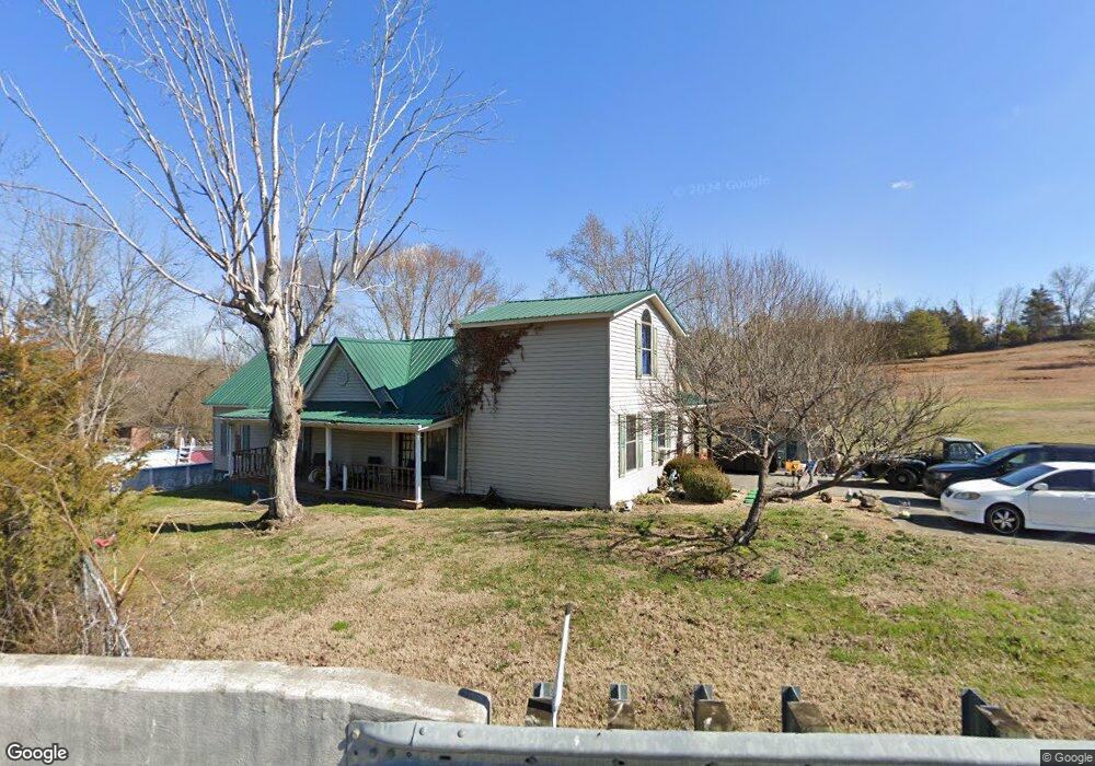
207 Summitt Hill Rd Bulls Gap, TN 37711
Estimated Value: $286,000 - $351,770
--
Bed
2
Baths
2,558
Sq Ft
$127/Sq Ft
Est. Value
About This Home
This home is located at 207 Summitt Hill Rd, Bulls Gap, TN 37711 and is currently estimated at $323,943, approximately $126 per square foot. 207 Summitt Hill Rd is a home located in Hawkins County with nearby schools including Bulls Gap School and Cherokee High School.
Ownership History
Date
Name
Owned For
Owner Type
Purchase Details
Closed on
Mar 25, 2016
Sold by
Collins Freddie
Bought by
Baxley Alvin L and Baxley Melissa A
Current Estimated Value
Purchase Details
Closed on
Aug 31, 1995
Sold by
Mccravey Charles S and Mccravey Wilma
Bought by
Freddie Collins
Purchase Details
Closed on
Sep 17, 1992
Bought by
Mccravey Charles S and Mccravey Wilma
Purchase Details
Closed on
Jul 24, 1978
Bought by
Kauffman Ralph Edward and Betty Marie
Purchase Details
Closed on
Jun 22, 1973
Create a Home Valuation Report for This Property
The Home Valuation Report is an in-depth analysis detailing your home's value as well as a comparison with similar homes in the area
Home Values in the Area
Average Home Value in this Area
Purchase History
| Date | Buyer | Sale Price | Title Company |
|---|---|---|---|
| Baxley Alvin L | $129,900 | -- | |
| Freddie Collins | $24,000 | -- | |
| Mccravey Charles S | $16,500 | -- | |
| Kauffman Ralph Edward | -- | -- | |
| -- | -- | -- |
Source: Public Records
Tax History Compared to Growth
Tax History
| Year | Tax Paid | Tax Assessment Tax Assessment Total Assessment is a certain percentage of the fair market value that is determined by local assessors to be the total taxable value of land and additions on the property. | Land | Improvement |
|---|---|---|---|---|
| 2024 | $1,319 | $51,650 | $6,100 | $45,550 |
| 2023 | $1,201 | $51,650 | $0 | $0 |
| 2022 | $1,197 | $51,650 | $6,100 | $45,550 |
| 2021 | $1,120 | $51,650 | $6,100 | $45,550 |
| 2020 | $886 | $51,650 | $6,100 | $45,550 |
| 2019 | $886 | $35,000 | $6,100 | $28,900 |
| 2018 | $886 | $35,000 | $6,100 | $28,900 |
| 2017 | $886 | $35,000 | $6,100 | $28,900 |
| 2016 | $886 | $35,000 | $6,100 | $28,900 |
| 2015 | $863 | $35,000 | $6,100 | $28,900 |
| 2014 | $931 | $37,750 | $6,100 | $31,650 |
Source: Public Records
Map
Nearby Homes
- 113 Old Highway Rd
- TBD Gap Creek Rd
- 334 S Fork Branch Rd
- 0 Walkers Church
- 251 Speedwell Ln
- 231 Guthries Gap Rd
- Lot 1 Walkers Church Rd
- Lot 2 Walkers Church Rd
- 0 Guthries Gap Rd Unit 611585
- Lot 2 Longtown Rd
- 887 Berry Rd
- 0 Seay Hollow Rd
- Tbd Seay Hollow Rd
- 185 Green Rd
- 000 Simpson Rd
- 168 Buzzard Roost Rd
- 204 Meadowview Rd
- 2586 Highway 66 S
- 140 Roberts Rd
- Tbd Lashay Ln
- 207 Summit Hill Rd
- 221 Summit Hill Rd
- 150 Summitt Hill Rd
- 221 Summitt Hill Rd
- 220 Summitt Hill Rd
- 220 Summitt Hill Rd
- 232 Summitt Hill Rd
- 223 Summit Hill Rd
- 135 Freeman Rd
- 223 Summitt Hill Rd
- 0 Summit Hill Rd Unit 556721
- 0 Summit Hill Rd Unit 1294030
- 260 Summit Hill Rd
- 00 Summit Hill Rd
- Tracts 10-14 Summit Hill Rd
- 250 Summitt Hill Rd
- 126 Summitt Hill Rd
- 260 Summitt Hill Rd
- 260 Summitt Hill Rd
- 0 Freeman Rd