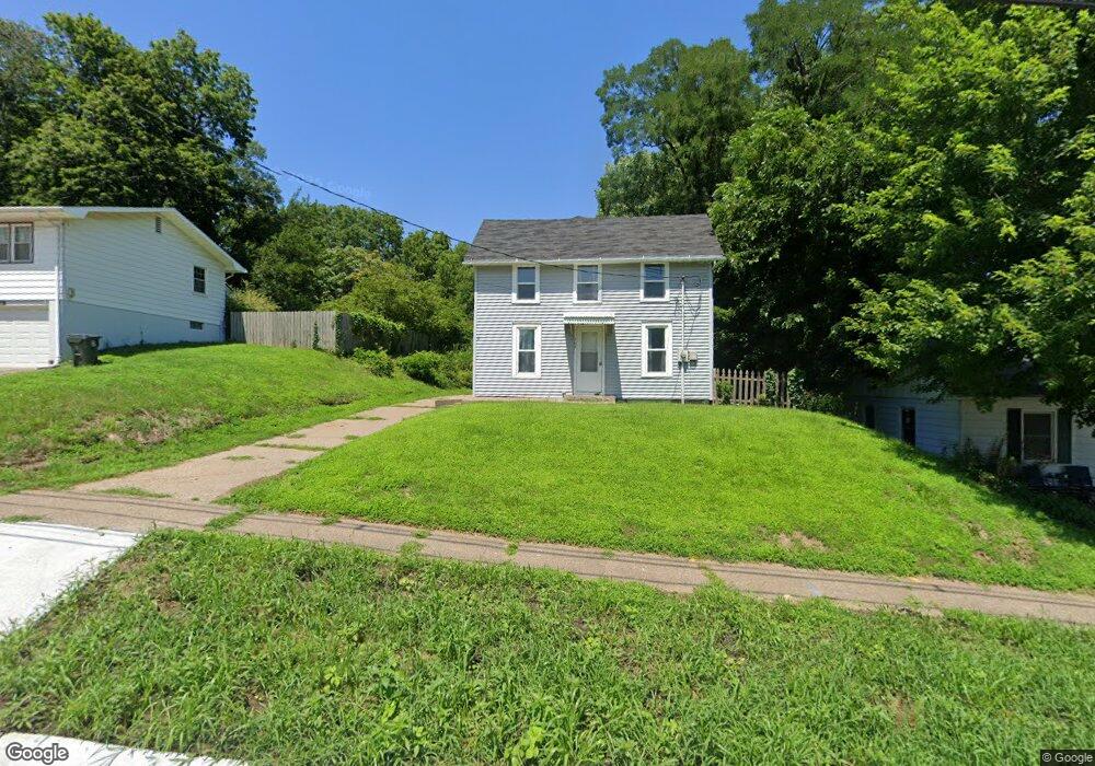
207 W Fulliam Ave Muscatine, IA 52761
Estimated Value: $113,087 - $165,000
4
Beds
2
Baths
1,408
Sq Ft
$100/Sq Ft
Est. Value
About This Home
This home is located at 207 W Fulliam Ave, Muscatine, IA 52761 and is currently estimated at $140,522, approximately $99 per square foot. 207 W Fulliam Ave is a home located in Muscatine County with nearby schools including Susan Clark Junior High School, Muscatine High School, and Saints Mary and Matthias Catholic School.
Ownership History
Date
Name
Owned For
Owner Type
Purchase Details
Closed on
Jan 6, 2023
Sold by
Goody Thomas
Bought by
Littrel Brian A
Current Estimated Value
Purchase Details
Closed on
Nov 29, 2010
Sold by
Graves Michael K and Wilges Don L
Bought by
Goody Linda
Home Financials for this Owner
Home Financials are based on the most recent Mortgage that was taken out on this home.
Original Mortgage
$100,000
Interest Rate
4.16%
Mortgage Type
Future Advance Clause Open End Mortgage
Create a Home Valuation Report for This Property
The Home Valuation Report is an in-depth analysis detailing your home's value as well as a comparison with similar homes in the area
Home Values in the Area
Average Home Value in this Area
Purchase History
| Date | Buyer | Sale Price | Title Company |
|---|---|---|---|
| Littrel Brian A | $75,000 | -- | |
| Goody Linda | $50,000 | None Available |
Source: Public Records
Mortgage History
| Date | Status | Borrower | Loan Amount |
|---|---|---|---|
| Previous Owner | Goody Linda | $100,000 |
Source: Public Records
Tax History Compared to Growth
Tax History
| Year | Tax Paid | Tax Assessment Tax Assessment Total Assessment is a certain percentage of the fair market value that is determined by local assessors to be the total taxable value of land and additions on the property. | Land | Improvement |
|---|---|---|---|---|
| 2025 | $2,018 | $111,370 | $28,030 | $83,340 |
| 2024 | $2,018 | $111,260 | $28,030 | $83,230 |
| 2023 | $1,922 | $110,473 | $27,984 | $82,489 |
| 2022 | $1,862 | $97,680 | $26,400 | $71,280 |
| 2021 | $1,862 | $91,280 | $26,400 | $64,880 |
| 2020 | $1,842 | $87,680 | $26,400 | $61,280 |
| 2019 | $1,414 | $64,000 | $0 | $0 |
| 2018 | $1,394 | $64,000 | $0 | $0 |
| 2017 | $1,446 | $64,000 | $0 | $0 |
| 2016 | $1,448 | $64,000 | $0 | $0 |
| 2015 | $1,448 | $62,120 | $0 | $0 |
| 2014 | $1,414 | $62,120 | $0 | $0 |
Source: Public Records
Map
Nearby Homes
- 518 Roscoe Ave
- 602 W Fulliam Ave
- 1506 Buell St
- 310 Wood Creek Ln
- 1102 Cedar St
- 241 Dillaway St
- PARCEL ID 0834280023 Dillaway St
- 1807 Mulberry Ave
- 297 Burnside Ave
- 804 Iowa Ave
- 213 E 8th St
- 106 E 8th St
- 1012 Orange St
- 711 Sycamore St
- LOT 75 Briman Prairie
- LOT 72 Briman Prairie
- 403 E 8th St
- 606 Leroy St
- 700 Cedar St
- 836 Newell Ave
- 205 W Fulliam Ave
- 203 W Fulliam Ave
- 209 W Fulliam Ave
- 201 W Fulliam Ave
- 202 W Fulliam Ave
- 125 W Fulliam Ave
- 130 W Fulliam Ave
- 221 W Fulliam Ave
- 126 W Fulliam Ave
- 121 W Fulliam Ave
- 227 W Fulliam Ave
- 212 W Fulliam Ave
- 120 W Fulliam Ave
- 224 W Fulliam Ave
- 115 W Fulliam Ave
- 301 W Fulliam Ave
- 228 W Fulliam Ave
- 3 Nelson Dr
- 111 W Fulliam Ave
- 116 W Fulliam Ave