S
Seller's Agent in 2025
Scott Carmody
RE/MAX Results
(651) 336-2996
3 in this area
40 Total Sales


Estimated Value: $391,000 - $414,000
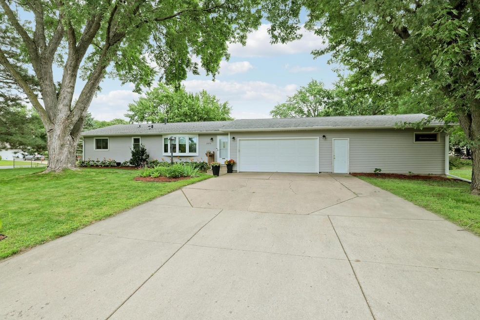
This beautifully updated five-bedroom, two-bathroom home offers spacious living with a convenient and rare find 4-car garage. Situated on a desirable corner lot, the property boasts tasteful modern updates throughout. Its prime location provides easy access to major roads and nearby shopping, making it an ideal choice for comfortable and convenient living.
We collect this data history from publicly available records. To have your information removed, we recommend requesting removal directly through your county’s website.
We collect this data history from publicly available records. To have your information removed, we recommend requesting removal directly through your county’s website.
| Date | Buyer | Sale Price | Title Company |
|---|---|---|---|
| $399,000 | On-Site Title | ||
| $309,900 | -- |
We collect this data history from publicly available records. To have your information removed, we recommend requesting removal directly through your county’s website.
| Date | Status | Borrower | Loan Amount |
|---|---|---|---|
| Open | $279,300 | ||
| Previous Owner | $304,286 |
We collect this data history from publicly available records. To have your information removed, we recommend requesting removal directly through your county’s website.
| Date | Event | Price | List to Sale | Price per Sq Ft |
|---|---|---|---|---|
| 09/30/2025 09/30/25 | Sold | $399,000 | -0.2% | $189 / Sq Ft |
| 09/08/2025 09/08/25 | Pending | -- | -- | -- |
| 08/29/2025 08/29/25 | For Sale | $399,900 | -- | $189 / Sq Ft |
We collect this data history from publicly available records. To have your information removed, we recommend requesting removal directly through your county’s website.
| Year | Tax Paid | Tax Assessment Tax Assessment Total Assessment is a certain percentage of the fair market value that is determined by local assessors to be the total taxable value of land and additions on the property. | Land | Improvement |
|---|---|---|---|---|
| 2025 | $3,916 | $388,900 | $85,600 | $303,300 |
| 2024 | $3,580 | $374,600 | $83,300 | $291,300 |
| 2023 | $3,580 | $378,200 | $83,500 | $294,700 |
| 2022 | $3,126 | $362,600 | $83,300 | $279,300 |
| 2021 | $3,076 | $318,200 | $74,600 | $243,600 |
| 2020 | $3,166 | $296,300 | $71,100 | $225,200 |
| 2019 | $3,115 | $293,200 | $67,700 | $225,500 |
| 2018 | $2,853 | $277,500 | $64,500 | $213,000 |
| 2017 | $2,646 | $246,500 | $61,400 | $185,100 |
| 2016 | $2,598 | $229,800 | $58,500 | $171,300 |
| 2015 | $2,459 | $200,053 | $53,758 | $146,295 |
| 2014 | -- | $196,129 | $52,124 | $144,005 |
| 2013 | -- | $162,448 | $45,755 | $116,693 |
S
Seller's Agent in 2025
Scott Carmody
RE/MAX Results
(651) 336-2996
3 in this area
40 Total Sales

Buyer's Agent in 2025
Danielle Maas
RE/MAX Results
(612) 454-9151
1 in this area
76 Total Sales
Source: NorthstarMLS
MLS Number: 6777869
APN: 10-16702-04-010
Disclaimer: Certain information contained herein is derived from information provided by parties other than Homes.com. All information provided is deemed reliable, but is not guaranteed to be accurate and should be independently verified.
![]() All data is obtained from various sources and may not have been verified by broker or MLS GRID. Supplied Open House Information is subject to change without notice. All information should be independently reviewed and verified for accuracy. Properties may or may not be listed by the office/agent presenting the information. Some IDX listings have been excluded from this website.
All data is obtained from various sources and may not have been verified by broker or MLS GRID. Supplied Open House Information is subject to change without notice. All information should be independently reviewed and verified for accuracy. Properties may or may not be listed by the office/agent presenting the information. Some IDX listings have been excluded from this website.
Listings courtesy of NorthstarMLS as distributed by MLS GRID.
Based on information submitted to the MLS GRID
Ask me questions while you tour the home.