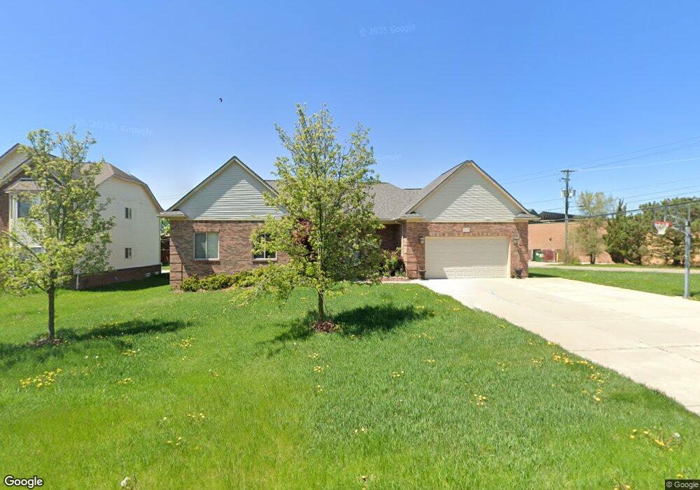
2070 St Josph West Bloomfield, MI 48324
Estimated Value: $463,000 - $619,499
3
Beds
3
Baths
1,744
Sq Ft
$325/Sq Ft
Est. Value
About This Home
This home is located at 2070 St Josph, West Bloomfield, MI 48324 and is currently estimated at $567,375, approximately $325 per square foot. 2070 St Josph is a home located in Oakland County with nearby schools including Walt Whitman Elementary School, Pontiac Middle School, and Pontiac High School.
Ownership History
Date
Name
Owned For
Owner Type
Purchase Details
Closed on
Oct 1, 2019
Sold by
Ammori Lway
Bought by
Ammori Emil
Current Estimated Value
Purchase Details
Closed on
Oct 21, 2011
Sold by
Ammori Youhanna
Bought by
Ammori Luay
Purchase Details
Closed on
Jan 7, 2009
Sold by
Ammori Design Llc
Bought by
Ammori Youhanna
Purchase Details
Closed on
May 18, 2007
Sold by
Johnston Daniel Michael and Hosler Lori Jean
Bought by
Ammori Design Llc
Purchase Details
Closed on
Sep 21, 2004
Sold by
Figa Investment Co Inc
Bought by
Johnston Daniel Michael and Hosler Lori Jean
Create a Home Valuation Report for This Property
The Home Valuation Report is an in-depth analysis detailing your home's value as well as a comparison with similar homes in the area
Home Values in the Area
Average Home Value in this Area
Purchase History
| Date | Buyer | Sale Price | Title Company |
|---|---|---|---|
| Ammori Emil | -- | None Available | |
| Ammori Luay | -- | None Available | |
| Ammori Youhanna | -- | None Available | |
| Ammori Design Llc | $60,000 | Philip R Seaver Title Co Inc | |
| Johnston Daniel Michael | $35,000 | Philip R Seaver Title Co Inc |
Source: Public Records
Tax History Compared to Growth
Tax History
| Year | Tax Paid | Tax Assessment Tax Assessment Total Assessment is a certain percentage of the fair market value that is determined by local assessors to be the total taxable value of land and additions on the property. | Land | Improvement |
|---|---|---|---|---|
| 2024 | $2,600 | $290,820 | $0 | $0 |
| 2022 | $2,481 | $273,680 | $26,950 | $246,730 |
| 2021 | $4,079 | $240,370 | $0 | $0 |
| 2020 | $2,284 | $216,050 | $26,950 | $189,100 |
| 2018 | $6,135 | $179,380 | $19,350 | $160,030 |
| 2015 | -- | $128,790 | $0 | $0 |
| 2014 | -- | $75,640 | $0 | $0 |
| 2011 | -- | $17,300 | $0 | $0 |
Source: Public Records
Map
Nearby Homes
- 2468 Walce Dr
- 2084 Woodrow Wilson Blvd Unit A6
- 2216 Middlebelt Rd
- 2230 Middlebelt Rd
- 1796 Briarcliff St
- 1775 Woodland Ave
- 2630 Depew Dr
- 2820 Wall St
- 2825 Wall St
- 1968 Maplewood Ave
- 2622 Pine Ridge Rd
- 1970 Beechmont St
- 2665 Middlebelt Rd
- 2952 Prynne St
- 2918 Nagle Ct
- 1785 Ward Rd
- 1947 Maplewood Ave
- 1253 Atkinson Ave
- 2960 Glenbroke St
- 1675 Dell Rose Dr
- 2070 St Joseph
- 2088 Saint Joseph St
- 2098 Saint Joseph St
- 2069 Saint Joseph St
- 2077 Saint Joseph St
- 2051 Saint Joseph St
- 2091 Saint Joseph St
- 2106 Saint Joseph St
- 2399 Figa Ave
- 2090 Middlebelt Rd
- 2103 Saint Joseph St
- 2120 Saint Joseph St Unit Bldg-Unit
- 2120 Saint Joseph St
- 2098 Middlebelt Rd
- 2117 Saint Joseph St Unit Bldg-Unit
- 2117 Saint Joseph St
- 2410 Chata Dr
- 2301 Figa Ave
- 2132 Saint Joseph St
- 2104 Middlebelt Rd