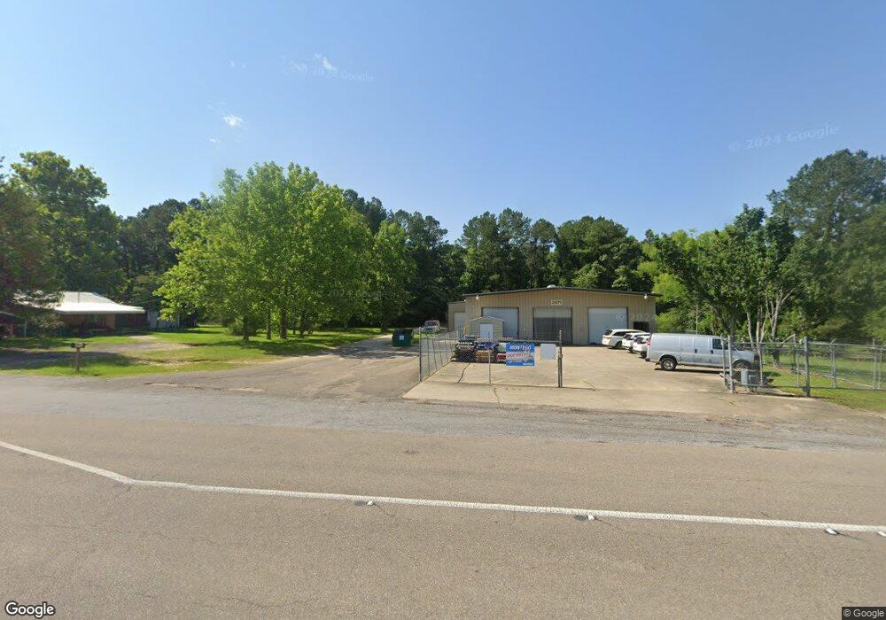
2071 Highway 184 Laurel, MS 39443
Studio
--
Bath
4,500
Sq Ft
65,340
Sq Ft Lot
About This Home
This home is located at 2071 Highway 184, Laurel, MS 39443. 2071 Highway 184 is a home located in Jones County with nearby schools including East Jones Elementary School, St. John's Day School, and Immaculate Conception School.
Ownership History
Date
Name
Owned For
Owner Type
Purchase Details
Closed on
Sep 1, 2009
Sold by
Trustees Of Powers Voluntary Fire Depart
Bought by
P & P Developers Llc
Home Financials for this Owner
Home Financials are based on the most recent Mortgage that was taken out on this home.
Original Mortgage
$53,429
Interest Rate
5.11%
Mortgage Type
Commercial
Create a Home Valuation Report for This Property
The Home Valuation Report is an in-depth analysis detailing your home's value as well as a comparison with similar homes in the area
Purchase History
| Date | Buyer | Sale Price | Title Company |
|---|---|---|---|
| P & P Developers Llc | -- | -- | |
| Kaul Manish | -- | -- |
Source: Public Records
Mortgage History
| Date | Status | Borrower | Loan Amount |
|---|---|---|---|
| Closed | Kaul Manish | $53,429 |
Source: Public Records
Tax History
| Year | Tax Paid | Tax Assessment Tax Assessment Total Assessment is a certain percentage of the fair market value that is determined by local assessors to be the total taxable value of land and additions on the property. | Land | Improvement |
|---|---|---|---|---|
| 2025 | $2,061 | $17,117 | $0 | $0 |
| 2024 | $2,146 | $16,958 | $0 | $0 |
| 2023 | $2,146 | $16,958 | $0 | $0 |
| 2022 | $2,194 | $16,958 | $0 | $0 |
| 2021 | $2,203 | $16,958 | $0 | $0 |
| 2020 | $2,339 | $17,690 | $0 | $0 |
| 2019 | $2,348 | $17,690 | $0 | $0 |
| 2018 | $2,340 | $17,690 | $0 | $0 |
| 2017 | $2,340 | $17,651 | $0 | $0 |
| 2016 | $2,375 | $18,327 | $0 | $0 |
| 2015 | -- | $13,511 | $0 | $0 |
| 2014 | -- | $13,511 | $0 | $0 |
Source: Public Records
Map
Nearby Homes
- 36 Powers Dr
- 8 Shadow Ridge Dr
- 00 Timber Ridge Dr
- 30 Shadow Ridge Dr
- 22 Shadow Ridge Dr
- 19 Shadow Ridge Dr
- 17 Shadow Ridge Dr
- 16 Shadow Ridge Dr
- 10 Shadow Ridge Dr
- 0 Crumbly Rd Unit 37440
- 12 Timber Ridge
- 27 Forest Glen Dr
- 224 Magnolia Rd
- 17 Stone Cut Off Rd
- 64 Eastview Cir
- 17 Eastview Dr
- 73 Pine Dr
- 0 Magnolia Rd
- 0 Wansley-Clark Dirt Pit Rd
- 215 Church Dr
- 2065 Highway 184
- 2065 Highway 184
- 4 Northeast Dr
- 2075 Highway 184
- 6 Spring Rd
- 5 Spring Rd
- 16 Northeast Dr
- 2051 Highway 184
- 2088 Highway 184
- 25 Northeast Dr
- 19 Spring Rd
- 2045 Highway 184
- 2058 Highway 184
- 2098 Highway 184
- 26 Northeast Dr
- 22 Spring Rd
- 2096 Highway 184
- 30 Northeast Dr
- 2106 Highway 184
- 2069 Highway 184
Your Personal Tour Guide
Ask me questions while you tour the home.