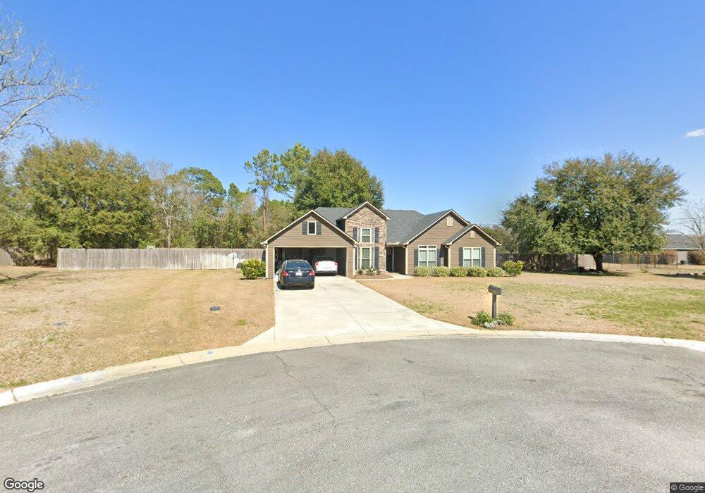
2071 Jason Cir Valdosta, GA 31601
Estimated Value: $247,000 - $377,000
3
Beds
2
Baths
1,672
Sq Ft
$173/Sq Ft
Est. Value
About This Home
This home is located at 2071 Jason Cir, Valdosta, GA 31601 and is currently estimated at $289,151, approximately $172 per square foot. 2071 Jason Cir is a home located in Lowndes County with nearby schools including Westside Elementary School, Hahira Middle School, and Lowndes High School.
Ownership History
Date
Name
Owned For
Owner Type
Purchase Details
Closed on
Sep 14, 2017
Sold by
Edward Jennings Llc
Bought by
Baker Ricky
Current Estimated Value
Home Financials for this Owner
Home Financials are based on the most recent Mortgage that was taken out on this home.
Original Mortgage
$182,848
Outstanding Balance
$152,650
Interest Rate
3.89%
Mortgage Type
VA
Estimated Equity
$136,501
Purchase Details
Closed on
Aug 26, 2007
Bought by
Edward Jennings Llc
Create a Home Valuation Report for This Property
The Home Valuation Report is an in-depth analysis detailing your home's value as well as a comparison with similar homes in the area
Home Values in the Area
Average Home Value in this Area
Purchase History
| Date | Buyer | Sale Price | Title Company |
|---|---|---|---|
| Baker Ricky | $179,000 | -- | |
| Edward Jennings Llc | -- | -- |
Source: Public Records
Mortgage History
| Date | Status | Borrower | Loan Amount |
|---|---|---|---|
| Open | Baker Ricky | $182,848 |
Source: Public Records
Tax History Compared to Growth
Tax History
| Year | Tax Paid | Tax Assessment Tax Assessment Total Assessment is a certain percentage of the fair market value that is determined by local assessors to be the total taxable value of land and additions on the property. | Land | Improvement |
|---|---|---|---|---|
| 2024 | $1,916 | $86,310 | $11,200 | $75,110 |
| 2023 | $1,916 | $86,391 | $11,200 | $75,191 |
| 2022 | $1,828 | $71,557 | $11,200 | $60,357 |
| 2021 | $1,806 | $68,028 | $11,200 | $56,828 |
| 2020 | $1,677 | $68,028 | $11,200 | $56,828 |
| 2019 | $1,695 | $68,028 | $11,200 | $56,828 |
| 2018 | $1,712 | $68,028 | $11,200 | $56,828 |
| 2017 | $157 | $5,600 | $5,600 | $0 |
| 2016 | $141 | $5,000 | $5,000 | $0 |
| 2015 | $135 | $5,000 | $5,000 | $0 |
| 2014 | $138 | $5,000 | $5,000 | $0 |
Source: Public Records
Map
Nearby Homes
- 2097 Lynnhaven Rd
- 2048 Dean St
- 2419 Treeview Dr
- 0 James Rd
- 201 Norman Dr
- 1817 W Hill Ave
- 211 Stella St
- 2337 W Savannah Ave
- 303 Nan St
- 1690 Ridgecrest St
- 230 Saint Augustine Rd
- 107 Jordan St
- 219 N St Augustine Rd
- 605 N Saint Augustine Rd
- 203 N Saint Augustine Rd
- TBD Moss Oak Dr
- 0 Saint Augustine Rd
- 2.54 Ac N St Augustine Rd
- 1430 W Magnolia St
- 316 Blitch St
- 2070 Jason Cir
- 2050 Holland Cir
- 2083 Jason Cir
- 2060 Holland Cir
- 2082 Jason Cir
- 2087 Jeffs Place
- 2095 Jason Cir
- 2051 Holland Cir
- 2452 James Rd
- 2101 Jeff's Place
- 2094 Jason Cir
- 2074 Holland Cir
- 2063 Holland Cir
- 2109 Jeffs Place
- 2103 Westside Rd
- 2073 Holland Cir
- 2086 Jeffs Place
- 2098 Jeffs Place
- 2110 Jeffs Place
- 2091 Lynnhaven Rd