Estimated Value: $688,000 - $722,000
5
Beds
3
Baths
2,966
Sq Ft
$238/Sq Ft
Est. Value
About This Home
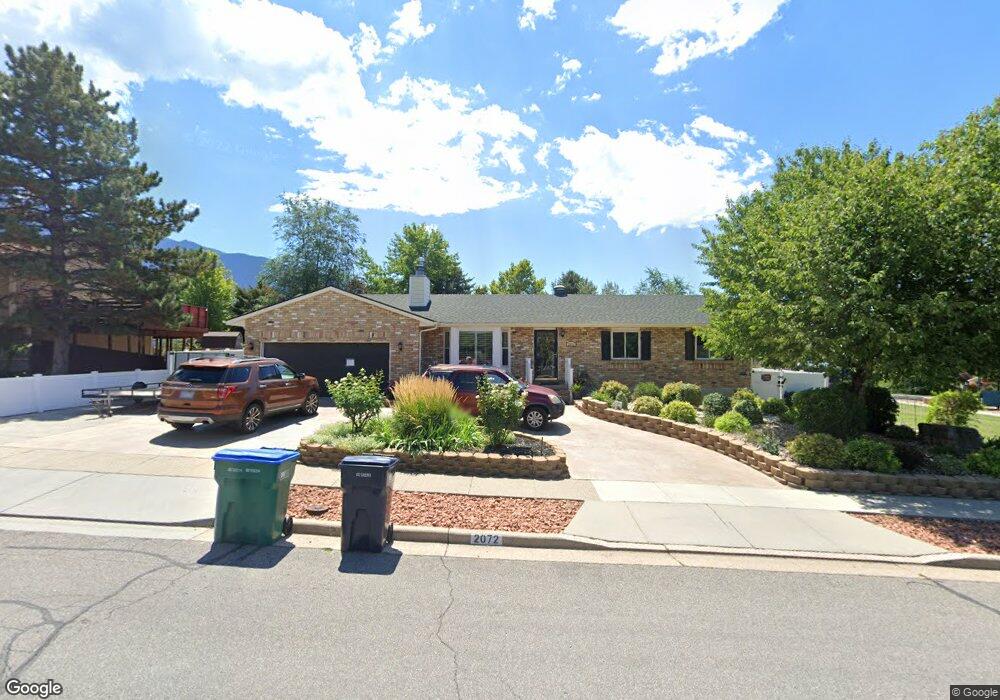
This home is located at 2072 E 9800 S, Sandy, UT 84092 and is currently estimated at $705,696, approximately $237 per square foot. 2072 E 9800 S is a home located in Salt Lake County with nearby schools including Park Lane Elementary School, Eastmont Middle School, and Jordan High.
Ownership History
Date
Name
Owned For
Owner Type
Purchase Details
Closed on
May 17, 2017
Sold by
Lundquist Floyd H and The Floyd H Lundquist Trust
Bought by
Lundquist Floyd H and Lundquist Marlene E
Current Estimated Value
Purchase Details
Closed on
Jun 27, 2016
Sold by
King Beverly L
Bought by
Lundquist Floyd H
Purchase Details
Closed on
Mar 18, 2016
Sold by
King Vicky L and King Beverley L
Bought by
King Beverley L
Purchase Details
Closed on
Jun 18, 2014
Sold by
King Vicky L
Bought by
King Vicky L and King Beverly L
Home Financials for this Owner
Home Financials are based on the most recent Mortgage that was taken out on this home.
Original Mortgage
$179,000
Interest Rate
4.16%
Mortgage Type
New Conventional
Create a Home Valuation Report for This Property
The Home Valuation Report is an in-depth analysis detailing your home's value as well as a comparison with similar homes in the area
Home Values in the Area
Average Home Value in this Area
Purchase History
| Date | Buyer | Sale Price | Title Company |
|---|---|---|---|
| Lundquist Floyd H | -- | None Available | |
| Lundquist Floyd H | -- | Pinnacle Title Co | |
| King Beverley L | -- | Landmark Title | |
| King Vicky L | -- | Landmark Title | |
| King Vicky L | -- | Us Title |
Source: Public Records
Mortgage History
| Date | Status | Borrower | Loan Amount |
|---|---|---|---|
| Previous Owner | King Vicky L | $179,000 |
Source: Public Records
Tax History
| Year | Tax Paid | Tax Assessment Tax Assessment Total Assessment is a certain percentage of the fair market value that is determined by local assessors to be the total taxable value of land and additions on the property. | Land | Improvement |
|---|---|---|---|---|
| 2025 | $802 | $645,800 | $236,000 | $409,800 |
| 2024 | $802 | $610,000 | $227,200 | $382,800 |
| 2023 | $871 | $598,900 | $218,400 | $380,500 |
| 2022 | $0 | $620,400 | $214,100 | $406,300 |
| 2021 | $2,555 | $450,500 | $164,000 | $286,500 |
| 2020 | $2,426 | $408,100 | $164,000 | $244,100 |
| 2019 | $2,441 | $400,700 | $154,700 | $246,000 |
| 2016 | $1,876 | $261,800 | $139,500 | $122,300 |
Source: Public Records
Map
Nearby Homes
- 2163 E Borg Dr
- 2170 E Borg Ct
- 1952 E Bluffside Cir
- 9650 S Buttonwood Dr
- 9525 S Carriage Chase Ln
- 2009 E Sweetbriar Ln
- 9472 S Tramway Dr
- 9472 Fox Hunt Dr
- 9969 Altamont Dr
- 9942 S Altamont Dr
- 9457 S Fox Hunt Dr Unit 49
- 9828 Pinehurst Dr
- 9979 S Albury Rd
- 2329 E Woodchuck Cir
- 1650 E Budding Dr
- 9971 Pinehurst Dr
- 1584 Petunia Way
- 10158 Buttercup Dr
- 1563 E Tameron Dr
- 10346 Wood Glen Cir
- 2082 E 9800 S
- 9834 Riggs Cir
- 9852 Riggs Cir
- 9830 Riggs Cir
- 2092 E 9800 S
- 9785 Granite Canyon Dr
- 2068 E Quartzridge Dr
- 9772 Rocklin Cir
- 9835 Riggs Cir
- 2102 E 9800 S
- 2063 E Riggs Dr
- 2063 Riggs Dr
- 2055 E Riggs Dr
- 2055 Riggs Dr
- 2058 Quartzridge Dr
- 9858 Riggs Cir
- 9783 Rocklin Cir
- 9858 S Riggs Cir
- 9767 Granite Canyon Dr
- 9767 S Granite Canyon Dr
Your Personal Tour Guide
Ask me questions while you tour the home.