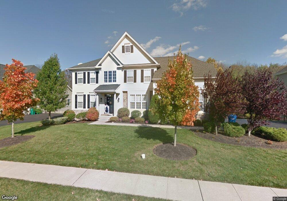
2073 Bedfordshire Rd Furlong, PA 18925
Estimated Value: $992,273 - $1,096,000
4
Beds
3
Baths
3,640
Sq Ft
$288/Sq Ft
Est. Value
About This Home
This home is located at 2073 Bedfordshire Rd, Furlong, PA 18925 and is currently estimated at $1,048,818, approximately $288 per square foot. 2073 Bedfordshire Rd is a home located in Bucks County with nearby schools including Bridge Valley Elementary School, Holicong Middle School, and Central Bucks High School - East.
Ownership History
Date
Name
Owned For
Owner Type
Purchase Details
Closed on
Dec 28, 2005
Sold by
Orleans Corp
Bought by
Bortolotti Robert J and Stuntz Cheryl A
Current Estimated Value
Home Financials for this Owner
Home Financials are based on the most recent Mortgage that was taken out on this home.
Original Mortgage
$522,300
Outstanding Balance
$275,573
Interest Rate
5.25%
Mortgage Type
Fannie Mae Freddie Mac
Estimated Equity
$773,245
Create a Home Valuation Report for This Property
The Home Valuation Report is an in-depth analysis detailing your home's value as well as a comparison with similar homes in the area
Home Values in the Area
Average Home Value in this Area
Purchase History
| Date | Buyer | Sale Price | Title Company |
|---|---|---|---|
| Bortolotti Robert J | $652,995 | None Available |
Source: Public Records
Mortgage History
| Date | Status | Borrower | Loan Amount |
|---|---|---|---|
| Open | Bortolotti Robert J | $522,300 |
Source: Public Records
Tax History Compared to Growth
Tax History
| Year | Tax Paid | Tax Assessment Tax Assessment Total Assessment is a certain percentage of the fair market value that is determined by local assessors to be the total taxable value of land and additions on the property. | Land | Improvement |
|---|---|---|---|---|
| 2025 | $10,039 | $61,660 | $11,230 | $50,430 |
| 2024 | $10,039 | $61,660 | $11,230 | $50,430 |
| 2023 | $9,699 | $61,660 | $11,230 | $50,430 |
| 2022 | $9,583 | $61,660 | $11,230 | $50,430 |
| 2021 | $9,468 | $61,660 | $11,230 | $50,430 |
| 2020 | $9,468 | $61,660 | $11,230 | $50,430 |
| 2019 | $9,406 | $61,660 | $11,230 | $50,430 |
| 2018 | $9,406 | $61,660 | $11,230 | $50,430 |
| 2017 | $9,329 | $61,660 | $11,230 | $50,430 |
| 2016 | $9,422 | $61,660 | $11,230 | $50,430 |
| 2015 | -- | $61,660 | $11,230 | $50,430 |
| 2014 | -- | $61,660 | $11,230 | $50,430 |
Source: Public Records
Map
Nearby Homes
- 2080 Bedfordshire Rd
- 2209 Swamp Rd
- 0 Old York Rd Unit PABU2103356
- 1948 Forest Grove Rd
- 3657 Powder Horn Dr
- 3772 Powder Horn Dr
- 3017 Dorchester St E Unit 125
- 2310 S Whittmore St
- 2113 Redbud Ln
- lot #3 next to 3739 York Rd
- 2443 Sugar Bottom Rd
- 4549 Lower Mountain Rd
- 106 Saddle Dr
- 547 Mccarty Dr
- 2479 Wheatfield Ln
- 2807 Mountain Laurel Dr
- 1515 Sugar Bottom Rd
- 108 Eagle Ct Unit 105
- 3889 Robin Rd
- 1249 Pebble Hill Rd
- 2065 Bedfordshire Rd
- 2081 Bedfordshire Rd
- 2057 Bedfordshire Rd
- 2089 Bedfordshire Rd
- 2072 Bedfordshire Rd
- 2064 Bedfordshire Rd
- 2088 Bedfordshire Rd
- 2056 Bedfordshire Rd
- 2049 Bedfordshire Rd
- 2097 Bedfordshire Rd
- 2067 Buckinghamshire Rd
- 2096 Bedfordshire Rd
- 2048 Bedfordshire Rd
- 2075 Buckinghamshire Rd
- 2051 Buckinghamshire Rd
- 2041 Bedfordshire Rd
- 2104 Bedfordshire Rd
- 2043 Buckinghamshire Rd
- 2030 Bedfordshire Rd
- 2083 Buckinghamshire Rd