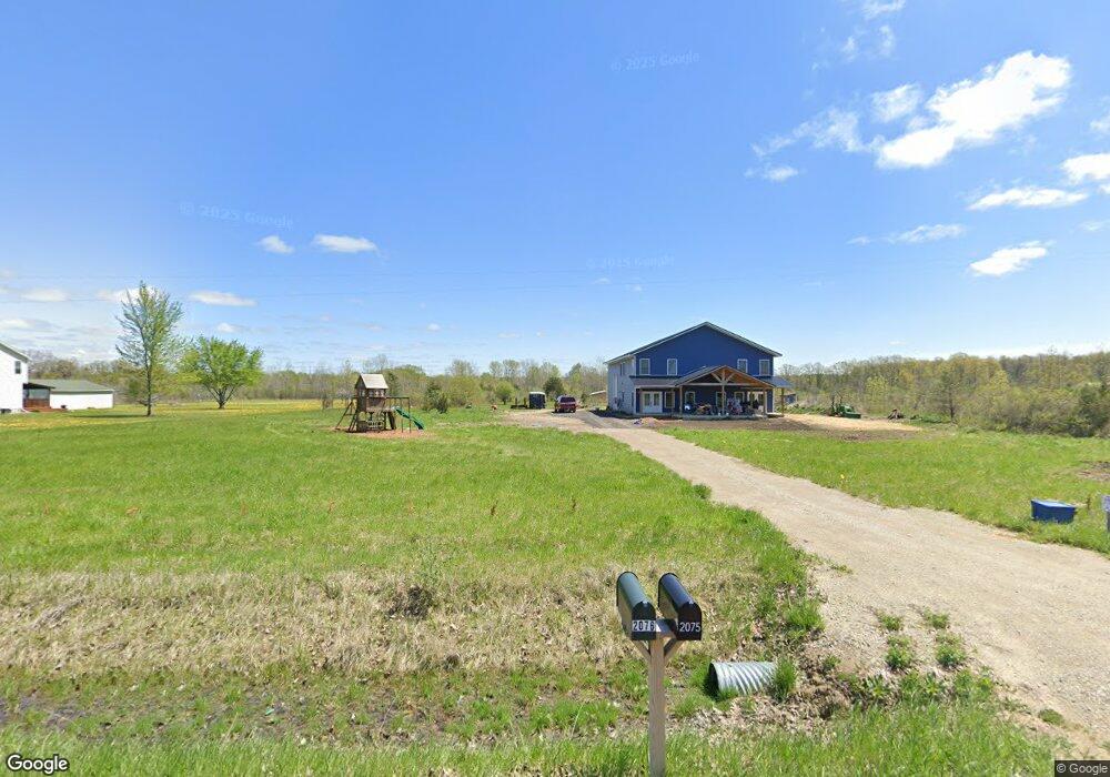
2075 Nichols Rd Lennon, MI 48449
Estimated Value: $77,000
--
Bed
--
Bath
2,760
Sq Ft
$28/Sq Ft
Est. Value
About This Home
This home is located at 2075 Nichols Rd, Lennon, MI 48449 and is currently estimated at $77,000, approximately $27 per square foot. 2075 Nichols Rd is a home located in Genesee County with nearby schools including Syring Elementary School, Elms Road Elementary School, and Dieck Elementary School.
Ownership History
Date
Name
Owned For
Owner Type
Purchase Details
Closed on
Jun 30, 2023
Sold by
Rybar Matthew
Bought by
Conley Wayne
Current Estimated Value
Home Financials for this Owner
Home Financials are based on the most recent Mortgage that was taken out on this home.
Original Mortgage
$285,500
Outstanding Balance
$278,808
Interest Rate
6.79%
Mortgage Type
Construction
Estimated Equity
-$201,808
Purchase Details
Closed on
Mar 21, 2022
Sold by
Anderson Jason M and Anderson Rebecca
Bought by
Rybar Matthew
Purchase Details
Closed on
Apr 30, 2021
Sold by
Crandell Matthew F and Crandell Juanita K
Bought by
Anderson Jason M and Anderson Rebecca
Home Financials for this Owner
Home Financials are based on the most recent Mortgage that was taken out on this home.
Original Mortgage
$35,250
Interest Rate
4.62%
Mortgage Type
New Conventional
Create a Home Valuation Report for This Property
The Home Valuation Report is an in-depth analysis detailing your home's value as well as a comparison with similar homes in the area
Home Values in the Area
Average Home Value in this Area
Purchase History
| Date | Buyer | Sale Price | Title Company |
|---|---|---|---|
| Conley Wayne | $69,000 | Ata National Title | |
| Rybar Matthew | $66,250 | None Listed On Document | |
| Anderson Jason M | $47,000 | Cislo Title Co |
Source: Public Records
Mortgage History
| Date | Status | Borrower | Loan Amount |
|---|---|---|---|
| Open | Conley Wayne | $285,500 | |
| Previous Owner | Anderson Jason M | $35,250 |
Source: Public Records
Tax History Compared to Growth
Tax History
| Year | Tax Paid | Tax Assessment Tax Assessment Total Assessment is a certain percentage of the fair market value that is determined by local assessors to be the total taxable value of land and additions on the property. | Land | Improvement |
|---|---|---|---|---|
| 2025 | $4,791 | $211,600 | $0 | $0 |
| 2024 | $957 | $83,300 | $0 | $0 |
| 2023 | $206 | $17,900 | $0 | $0 |
| 2022 | $842 | $15,400 | $0 | $0 |
| 2021 | $651 | $17,300 | $0 | $0 |
| 2020 | $136 | $17,300 | $0 | $0 |
| 2019 | $134 | $17,400 | $0 | $0 |
| 2018 | $563 | $14,200 | $0 | $0 |
| 2017 | $541 | $14,200 | $0 | $0 |
| 2016 | $539 | $14,200 | $0 | $0 |
| 2015 | $528 | $10,900 | $0 | $0 |
| 2014 | $125 | $10,900 | $0 | $0 |
| 2012 | -- | $10,900 | $10,900 | $0 |
Source: Public Records
Map
Nearby Homes
- 1475 S Nichols Rd
- 11424 Corunna Rd
- 0 Corunna Rd Unit 20251051464
- 1309 Houston Dr
- 10141 McEnrue Rd
- 12502 W Corunna Rd
- 3086 Seymour Rd
- 241 Raleigh Place
- 2548 S Sheridan Rd
- V/L S Sheridan Rd
- 4014 S Duffield Rd
- 908 Tyler Rd
- 805 Oak St
- 1445 N Seymour Rd
- 3375 Seymour Rd
- 1513 N Seymour Rd
- 0 Corunna Rd Unit 20251034900
- 4101 S Sheridan Rd Unit 132
- 1936 Elmwood Dr
- TBD E Brooks Rd N of Us 69 W of M13
- 2076 Nichols Rd
- 2096 Nichols Rd
- 2096 Nichols Rd
- 2055 Nichols Rd
- 2114 Nichols Rd
- 2029 Nichols Rd
- 2134 Nichols Rd
- 2029 S Nichols Rd
- 11049 W Corunna Rd
- 2115 Nichols Rd
- 2095 Nichols Rd
- 11020 W Corunna Rd
- 1501 Nichols Rd
- 1501 Nichols Rd
- 2170 Nichols Rd
- 2163 Nichols Rd
- 11089 W Corunna Rd
- 1475 Nichols Rd
- 2184 Nichols Rd
- 11111 W Corunna Rd