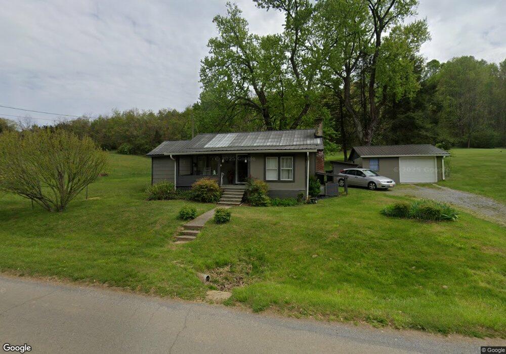
2077 Sulphur Springs Rd Morristown, TN 37813
Estimated Value: $109,013 - $184,000
--
Bed
1
Bath
988
Sq Ft
$148/Sq Ft
Est. Value
About This Home
This home is located at 2077 Sulphur Springs Rd, Morristown, TN 37813 and is currently estimated at $145,753, approximately $147 per square foot. 2077 Sulphur Springs Rd is a home located in Hamblen County with nearby schools including Witt Elementary School, Lincoln Heights Middle School, and Morristown West High School.
Ownership History
Date
Name
Owned For
Owner Type
Purchase Details
Closed on
Feb 6, 2020
Sold by
Ballard James Roy and Ballard Patricia
Bought by
Moran Tom and Moran Connie
Current Estimated Value
Home Financials for this Owner
Home Financials are based on the most recent Mortgage that was taken out on this home.
Original Mortgage
$36,000
Outstanding Balance
$31,960
Interest Rate
3.74%
Mortgage Type
Seller Take Back
Estimated Equity
$113,793
Purchase Details
Closed on
Jul 20, 1970
Bought by
Davis Willie K and Mary Ann
Create a Home Valuation Report for This Property
The Home Valuation Report is an in-depth analysis detailing your home's value as well as a comparison with similar homes in the area
Home Values in the Area
Average Home Value in this Area
Purchase History
| Date | Buyer | Sale Price | Title Company |
|---|---|---|---|
| Moran Tom | $45,000 | None Available | |
| Davis Willie K | -- | -- |
Source: Public Records
Mortgage History
| Date | Status | Borrower | Loan Amount |
|---|---|---|---|
| Open | Moran Tom | $36,000 |
Source: Public Records
Tax History Compared to Growth
Tax History
| Year | Tax Paid | Tax Assessment Tax Assessment Total Assessment is a certain percentage of the fair market value that is determined by local assessors to be the total taxable value of land and additions on the property. | Land | Improvement |
|---|---|---|---|---|
| 2024 | $222 | $11,250 | $2,050 | $9,200 |
| 2023 | $222 | $11,250 | $0 | $0 |
| 2022 | $222 | $11,250 | $2,050 | $9,200 |
| 2021 | $222 | $11,250 | $2,050 | $9,200 |
| 2020 | $222 | $11,250 | $2,050 | $9,200 |
| 2019 | $207 | $9,725 | $1,950 | $7,775 |
| 2018 | $207 | $9,725 | $1,950 | $7,775 |
| 2017 | $207 | $9,725 | $1,950 | $7,775 |
| 2016 | $188 | $9,725 | $1,950 | $7,775 |
| 2015 | $180 | $9,725 | $1,950 | $7,775 |
| 2014 | -- | $9,725 | $1,950 | $7,775 |
| 2013 | -- | $10,175 | $0 | $0 |
Source: Public Records
Map
Nearby Homes
- 1418 Mae Collins Rd
- 1160 Statem Gap Rd
- 453 Statem Gap Rd
- 203 Lincoln Ave
- 2018 Southwood Cir
- Darwin Plan at Southwood
- Robie Plan at Southwood
- Elston Plan at Southwood
- Belhaven Plan at Southwood
- Penwell Plan at Southwood
- Cali Plan at Southwood
- 1049 Greenway Dr
- 305-365 Barkley Landing Dr
- 440 S Fairmont Ave
- 837 Pauline Ave
- 731 Lennie Ave
- 2895 Coffey Rd
- 811 Crescent St
- 323 Pauline Ave
- 1621 S Cumberland St
- 2087 Sulphur Springs Rd
- 2088 Sulphur Springs Rd
- 2061 Sulphur Springs Rd
- 2100 Sulphur Springs Rd
- 2099 Sulphur Springs Rd
- 2106 Sulphur Springs Rd
- 2092 Sulphur Springs Rd
- 2051 Sulphur Springs Rd
- 2109 Sulphur Springs Rd
- 2078 Sulphur Springs Rd
- 2118 Sulphur Springs Rd
- 2096 Sulphur Springs Rd
- 1980 Brookside Dr
- 1981 Brookside Dr
- 2131 Sulphur Springs Rd
- 2122 Sulphur Springs Rd
- 1918 Misty Wood Dr
- 1971 Brookside Dr
- 2128 Sulphur Springs Rd
- 1996 Brookside Dr