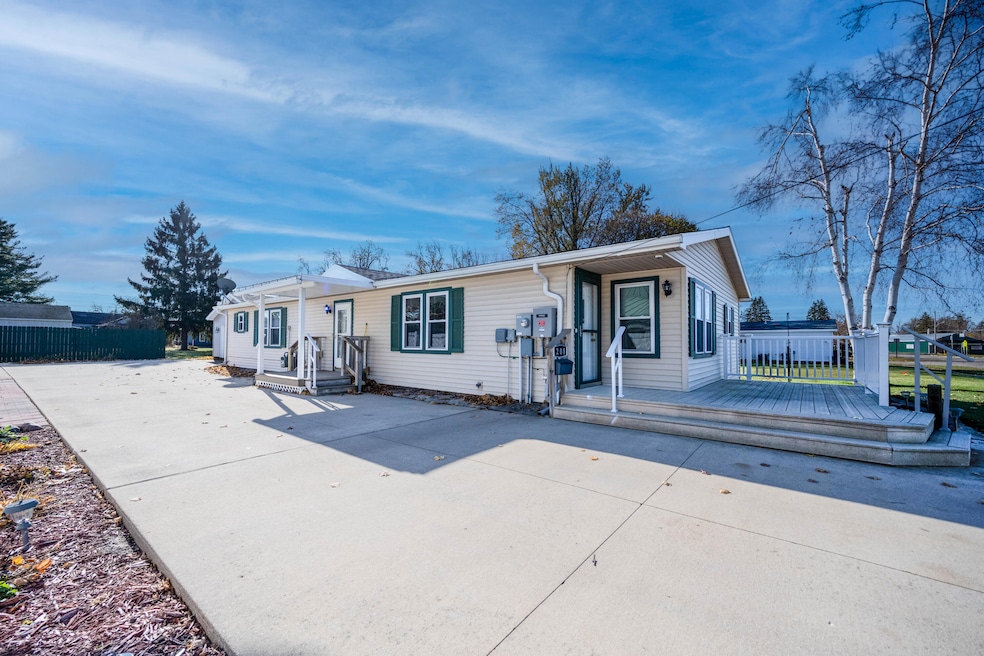
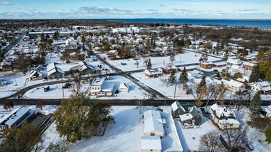
208 Duncan Ave Cheboygan, MI 49721
Estimated payment $1,342/month
Highlights
- Ranch Style House
- First Floor Utility Room
- Patio
- No HOA
- 2 Car Detached Garage
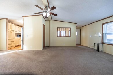
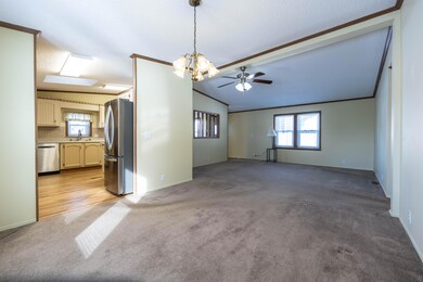
- Living Room
About This Lot
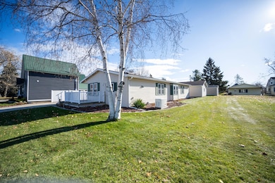
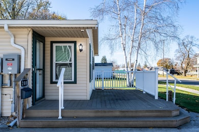
Welcome to 208 Duncan! This beautifully maintained 3-bedroom, 2-bath home has been lovingly cared for and thoughtfully updated, making it completely move-in ready. Step inside and you'll immediately notice the many updates throughout — including countertops, freshly painted cabinets, new appliances, and new vinyl laminate flooring. Every detail has been attended to with pride of ownership shining through in every room. The 24x24 detached garage offers plenty of room for vehicles and storage. The cement driveway provides a clean and durable finish. A Generac generator adds peace of mind! The insulation was upgraded with RetroFoam in 2020. Located in the heart of Cheboygan, this home is just a short walk to the Cheboygan River, parks, coffee shop, farmers market and restaurants.
Listing Agent
COLDWELL BANKER SCHMIDT CHEBOYGAN License #6501431558 Listed on: 11/11/2025

Property Details
Property Type
- Land
Est. Annual Taxes
- $1,623
Year Built
- Built in 1993
Lot Details
- Lot Dimensions are 80x127
- Landscaped
Home Design
- Ranch Style House
Interior Spaces
- 1,540 Sq Ft Home
- Living Room
- Dining Room
- First Floor Utility Room
- Crawl Space
Kitchen
- Oven or Range
- Dishwasher
Bedrooms and Bathrooms
- 3 Bedrooms
- 2 Full Bathrooms
Laundry
- Laundry on main level
- Dryer
- Washer
Parking
- 2 Car Detached Garage
- Heated Garage
- Garage Door Opener
- Driveway
Schools
- Cheboygan Elementary School
- Cheboygan High School
Utilities
- Central Heating
- Power Generator
- Water Softener
- Municipal Utilities District Sewer
Listing and Financial Details
- Assessor Parcel Number 052-B05-001-003-00
- Tax Block SEC 32
Community Details
Overview
- No Home Owners Association
- T38n,R1w Subdivision
Recreation
- Patio
Map
Home Values in the Area
Average Home Value in this Area
Tax History
| Year | Tax Paid | Tax Assessment Tax Assessment Total Assessment is a certain percentage of the fair market value that is determined by local assessors to be the total taxable value of land and additions on the property. | Land | Improvement |
|---|---|---|---|---|
| 2025 | $1,623 | $77,800 | $0 | $0 |
| 2024 | $1,187 | $66,400 | $0 | $0 |
| 2023 | $1,140 | $58,000 | $0 | $0 |
| 2022 | $1,101 | $54,400 | $0 | $0 |
| 2021 | $1,399 | $49,600 | $49,600 | $0 |
| 2020 | $1,386 | $50,600 | $50,600 | $0 |
| 2019 | $1,350 | $42,700 | $42,700 | $0 |
| 2018 | $1,316 | $38,000 | $0 | $0 |
| 2017 | $1,271 | $37,900 | $0 | $0 |
| 2016 | $1,256 | $38,300 | $0 | $0 |
| 2015 | -- | $33,200 | $0 | $0 |
| 2014 | -- | $31,900 | $0 | $0 |
| 2012 | -- | $30,900 | $0 | $0 |
Property History
| Date | Event | Price | List to Sale | Price per Sq Ft |
|---|---|---|---|---|
| 11/11/2025 11/11/25 | For Sale | $229,000 | -- | $149 / Sq Ft |
Purchase History
| Date | Type | Sale Price | Title Company |
|---|---|---|---|
| Quit Claim Deed | -- | -- | |
| Quit Claim Deed | $1,700 | -- | |
| Warranty Deed | $78,000 | -- | |
| Warranty Deed | $6,900 | -- | |
| Quit Claim Deed | $3,800 | -- | |
| Deed | $1,600 | -- |
Source: Water Wonderland Board of REALTORS®
MLS Number: 201837962
APN: 052-B05-001-003-00
Disclaimer: Certain information contained herein is derived from information provided by parties other than Homes.com. All information provided is deemed reliable, but is not guaranteed to be accurate and should be independently verified.
![]() The data relating to real estate on this web site comes in part from the Internet
The data relating to real estate on this web site comes in part from the Internet
Data Exchange Program of the Water Wonderland MLS (WWLX). Real estate
listings held by brokerage firms other than Ten-X are marked with the WWLX
logo and the detailed information about said listing includes the listing office.
All information deemed reliable but not guaranteed and should be independently verified. All properties are subject to prior sale, change or withdrawal. Neither the listing broker(s) nor Ten-X shall be responsible for any typographical errors, misinformation, misprints, and shall be held totally harmless. Water Wonderland MLS, Inc © All rights reserved.
WWLX information is provided exclusively for consumers' personal, non-commercial use and may not be used for any purpose other than to identify prospective properties consumers may be interested in purchasing.
- 1108 S Huron St
- 1225 Grandview Beach Rd
- 4646 S Straits Hwy
- 4846 S Straits Hwy
- 6679 San Juan Unit 40
- 262 Highland Pike Rd
- 118 Rosedale Ave
- 501 Valley Ridge Dr
- 301 Lafayette Ave
- 624 Michigan St Unit 4
- 524 State St Unit 6
- 423 Pearl St Unit 2
- 522 Liberty St Unit B
- 1115 Emmet St
- 1420 Standish Ave
- 709 Jackson St Unit 9
- 1301 Crestview Dr
- 1401 Crestview Dr
- 1600 Bear Creek Ln