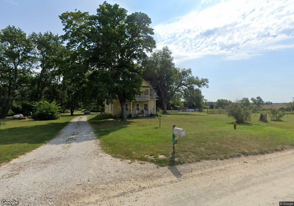
208 E 1600 Rd Baldwin City, KS 66006
Estimated Value: $390,000 - $600,000
4
Beds
2
Baths
1,995
Sq Ft
$253/Sq Ft
Est. Value
About This Home
This home is located at 208 E 1600 Rd, Baldwin City, KS 66006 and is currently estimated at $504,068, approximately $252 per square foot. 208 E 1600 Rd is a home located in Douglas County with nearby schools including Baldwin Elementary Primary Center, Baldwin Elementary Intermediate Center, and Baldwin Junior High School.
Ownership History
Date
Name
Owned For
Owner Type
Purchase Details
Closed on
Nov 19, 2008
Sold by
Brittain Catherine N and Estate Of James A Brittain
Bought by
Morgison Daryl and Morgison Delores
Current Estimated Value
Home Financials for this Owner
Home Financials are based on the most recent Mortgage that was taken out on this home.
Original Mortgage
$151,200
Outstanding Balance
$101,289
Interest Rate
6.5%
Mortgage Type
Purchase Money Mortgage
Estimated Equity
$402,779
Purchase Details
Closed on
Feb 29, 2008
Sold by
Brittain James A and Wynes Shirley K Valentine
Bought by
Brittain James A
Home Financials for this Owner
Home Financials are based on the most recent Mortgage that was taken out on this home.
Original Mortgage
$300,000
Interest Rate
2.91%
Mortgage Type
Reverse Mortgage Home Equity Conversion Mortgage
Create a Home Valuation Report for This Property
The Home Valuation Report is an in-depth analysis detailing your home's value as well as a comparison with similar homes in the area
Home Values in the Area
Average Home Value in this Area
Purchase History
| Date | Buyer | Sale Price | Title Company |
|---|---|---|---|
| Morgison Daryl | $189,000 | Ct | |
| Brittain James A | -- | First American Title Ins |
Source: Public Records
Mortgage History
| Date | Status | Borrower | Loan Amount |
|---|---|---|---|
| Open | Morgison Daryl | $151,200 | |
| Previous Owner | Brittain James A | $300,000 |
Source: Public Records
Tax History Compared to Growth
Tax History
| Year | Tax Paid | Tax Assessment Tax Assessment Total Assessment is a certain percentage of the fair market value that is determined by local assessors to be the total taxable value of land and additions on the property. | Land | Improvement |
|---|---|---|---|---|
| 2025 | $5,584 | $52,199 | $13,231 | $38,968 |
| 2024 | $5,584 | $49,312 | $12,233 | $37,079 |
| 2023 | $5,595 | $47,466 | $11,543 | $35,923 |
| 2022 | $5,268 | $43,150 | $10,666 | $32,484 |
| 2021 | $4,665 | $36,881 | $9,238 | $27,643 |
| 2020 | $4,323 | $33,750 | $9,238 | $24,512 |
| 2019 | $4,125 | $32,142 | $8,812 | $23,330 |
| 2018 | $4,398 | $34,057 | $8,734 | $25,323 |
| 2017 | $3,458 | $25,893 | $8,734 | $17,159 |
| 2016 | $3,159 | $23,984 | $7,021 | $16,963 |
| 2015 | $2,969 | $22,799 | $7,021 | $15,778 |
| 2014 | $2,821 | $21,250 | $7,021 | $14,229 |
Source: Public Records
Map
Nearby Homes
- 1841 College St
- 1512 College St
- 80 E 1600 Rd
- 99 E 1600 Rd
- 99 E 1600 Rd Unit Parcel 4
- 908 & 912 Orange St
- 1203 8th St
- 1019 8th St
- 814 Indiana St
- 702 Newton St
- 1115 7th St
- 703 Jersey St
- 94 E 1600 Rd
- 1015 Firetree Ave
- 612 Flame Way
- Lot 7 Block 2 Bluestem Dr
- Lot 6 Block 2 Bluestem Dr
- Lot 4 Block 2 Bluestem Dr
- Lot 3 Block 2 Bluestem Dr
- Lot 5 Block 3 Bluestem Dr
- 208 E 1600 Rd
- 210 E 1600th Rd
- 1226 Lawrence St
- 208 E 1000th Rd
- 1225 Summit St
- 1221 Summit St
- 1611 Mustang Dr
- 1217 Summit St
- 1224 Summit St
- 1607 Mustang Dr
- 1213 Summit St
- 1220 Summit St
- 191 E 1600th Rd
- 1221 Bison Ct
- 1216 Summit St
- 1217 Bison Ct
- 1209 Summit St
- 1513 Mustang Dr
- 1212 Summit St
- 1213 Bison Ct