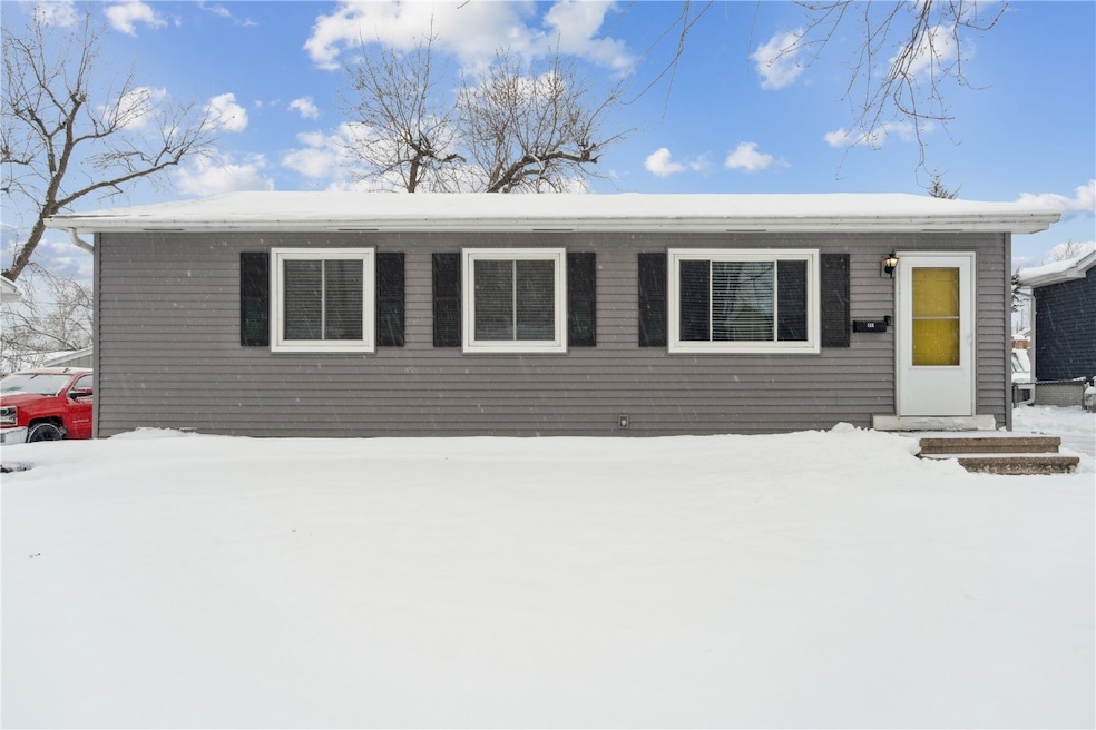
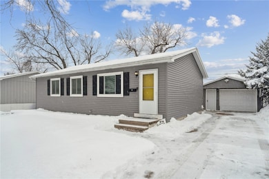

208 Lenora Dr NW Cedar Rapids, IA 52405
Cherry Hill Park NeighborhoodEstimated payment $1,375/month
Highlights
- 1 Car Detached Garage
- Eat-In Kitchen
- Living Room
- Junction City Elementary School Rated A
- Patio
- Guest Parking
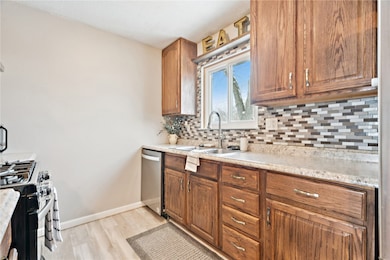
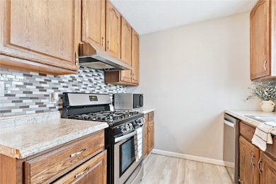
About This Home
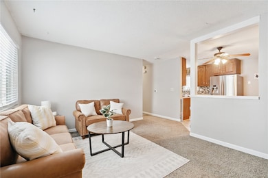
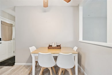
Welcome to your hidden hideaway in Cedar Hills! This beautifully maintained ranch is truly move-in ready and packed with quality updates. The main level features three generous bedrooms, an inviting living area, and a tastefully updated kitchen with newer appliances. Major improvements include a new roof (2020) and new furnace, A/C, and water heater (2023), offering peace of mind for years to come. The fully finished, waterproofed basement—complete with radon mitigation—provides excellent additional living or recreational space. Outside, the oversized 1.5-stall garage is ideal for extra storage or hobbyists, featuring convenient 220V hookups. With its fantastic location, modern updates, and undeniable charm, this adorable home is ready for its next owner. Just move in and enjoy!
Open House Schedule
-
Sunday, December 07, 202512:00 to 1:30 pm12/7/2025 12:00:00 PM +00:0012/7/2025 1:30:00 PM +00:00Hosted by Zach BorrettAdd to Calendar
Home Details
Home Type
- Single Family
Est. Annual Taxes
- $2,658
Year Built
- Built in 1970
Lot Details
- Lot Dimensions are 64 x 100
- Fenced
Parking
- 1 Car Detached Garage
- Garage Door Opener
- Guest Parking
- On-Street Parking
- Off-Street Parking
Home Design
- Poured Concrete
- Frame Construction
- Vinyl Siding
Interior Spaces
- 1-Story Property
- Family Room
- Living Room
- Basement Fills Entire Space Under The House
Kitchen
- Eat-In Kitchen
- Range
- Dishwasher
Bedrooms and Bathrooms
- 4 Bedrooms
- 2 Full Bathrooms
Outdoor Features
- Patio
Schools
- Hoover Elementary School
- Roosevelt Middle School
- Jefferson High School
Utilities
- Central Air
- Heating System Uses Gas
- Gas Water Heater
Listing and Financial Details
- Assessor Parcel Number 132528300800000
Map
Home Values in the Area
Average Home Value in this Area
Tax History
| Year | Tax Paid | Tax Assessment Tax Assessment Total Assessment is a certain percentage of the fair market value that is determined by local assessors to be the total taxable value of land and additions on the property. | Land | Improvement |
|---|---|---|---|---|
| 2025 | $2,658 | $178,800 | $35,200 | $143,600 |
| 2024 | $2,888 | $175,800 | $35,200 | $140,600 |
| 2023 | $2,888 | $160,700 | $30,400 | $130,300 |
| 2022 | $2,760 | $145,800 | $30,400 | $115,400 |
| 2021 | $2,656 | $142,200 | $27,200 | $115,000 |
| 2020 | $2,656 | $129,000 | $22,400 | $106,600 |
| 2019 | $2,618 | $121,500 | $22,400 | $99,100 |
| 2018 | $2,546 | $121,500 | $22,400 | $99,100 |
| 2017 | $2,546 | $114,800 | $22,400 | $92,400 |
| 2016 | $2,357 | $110,900 | $22,400 | $88,500 |
| 2015 | $2,447 | $115,023 | $22,400 | $92,623 |
| 2014 | $2,262 | $115,023 | $22,400 | $92,623 |
| 2013 | $2,210 | $115,023 | $22,400 | $92,623 |
Property History
| Date | Event | Price | List to Sale | Price per Sq Ft |
|---|---|---|---|---|
| 12/02/2025 12/02/25 | For Sale | $219,900 | -- | $145 / Sq Ft |
Purchase History
| Date | Type | Sale Price | Title Company |
|---|---|---|---|
| Warranty Deed | $137,000 | None Available | |
| Warranty Deed | $116,500 | None Available |
Mortgage History
| Date | Status | Loan Amount | Loan Type |
|---|---|---|---|
| Open | $109,600 | New Conventional | |
| Previous Owner | $93,592 | Fannie Mae Freddie Mac |
Source: Cedar Rapids Area Association of REALTORS®
MLS Number: 2509637
APN: 13252-83008-00000
Disclaimer: Certain information contained herein is derived from information provided by parties other than Homes.com. All information provided is deemed reliable, but is not guaranteed to be accurate and should be independently verified.
![]() IDX information is provided exclusively for personal, non-commercial use, and may not be used for any purpose other than to identify prospective properties consumers may be interested in purchasing.
IDX information is provided exclusively for personal, non-commercial use, and may not be used for any purpose other than to identify prospective properties consumers may be interested in purchasing.
Information is deemed reliable but not guaranteed.
- 229 Jacolyn Dr NW
- 4819 Ford Ave NW
- 272 Peace Ave NW
- 4910 Gordon Ave NW
- 281 Jacolyn Dr NW
- 4975 Kesler Rd NW
- 5127 Holly Ave NW
- 4622 1st Ave NW Unit E
- 4619 1st Ave SW Unit 3
- 106 Leroy St NW
- 150 Meadowlark Ln NW
- 56 Julia Ann Dr NW
- 4819 Fruitwood Ln NW
- 3600 Midway Dr NW
- 3724 2nd Ave SW
- 5536 Sharon Ln NW
- 5530 Skyline Dr NW
- 3416 Sue Ln NW
- 3509 E Ave NW Unit D
- 3507 E Ave NW Unit F
- 110 Jacolyn Dr SW
- 4419 1st Ave SW
- 4900 16th Ave SW
- 5150 16th Ave SW
- 5200 16th Ave SW
- 1210 Auburn Dr SW
- 470 Quail Ct SW
- 3200-3201 G Ave NW
- 4227 21st Ave SW
- 1270 Edgewood Rd NW
- 321 28th St NW
- 2155 Westdale Dr SW
- 1601 30th St NW
- 3205 Samuel Ct SW
- 2141 29th St NW
- 3320 Queen Dr
- 2202-2238 River Bluffs Dr
- 3404 Queen Dr SW
- 3101 Stoney Point Rd SW
- 2415 River Bluff Dr NW
