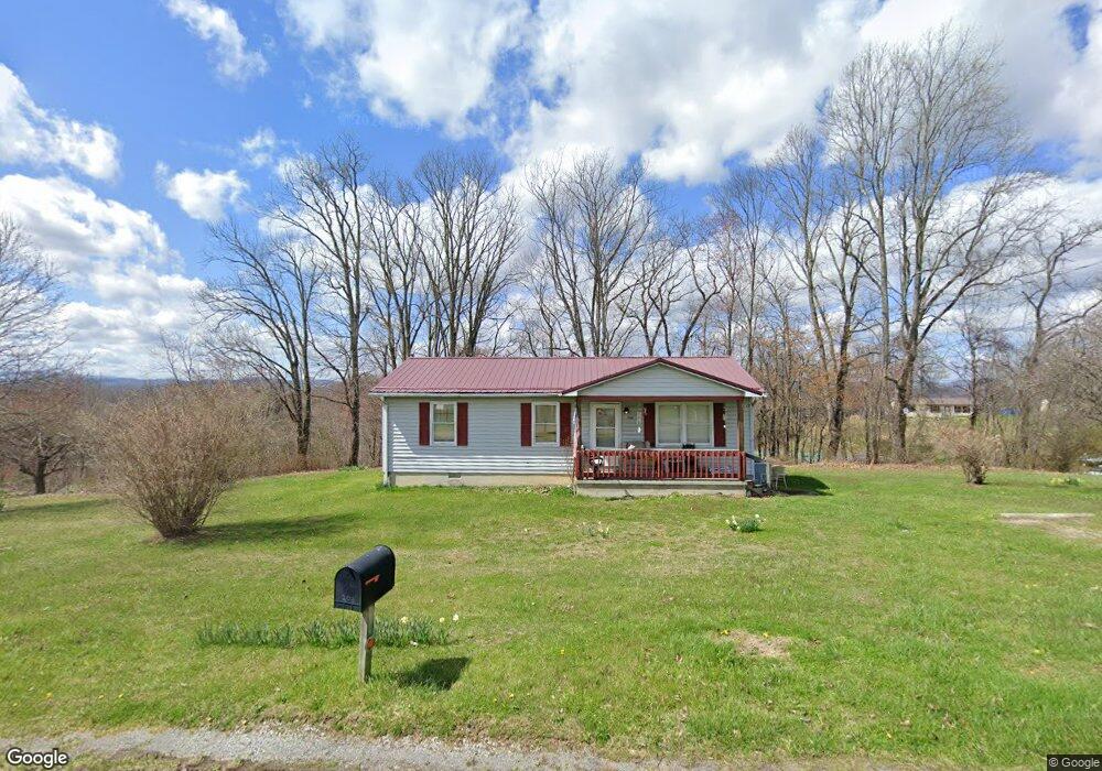
208 Paul Stanley Rd Coeburn, VA 24230
Estimated Value: $103,000 - $137,000
3
Beds
1
Bath
960
Sq Ft
$126/Sq Ft
Est. Value
About This Home
This home is located at 208 Paul Stanley Rd, Coeburn, VA 24230 and is currently estimated at $121,358, approximately $126 per square foot. 208 Paul Stanley Rd is a home located in Dickenson County with nearby schools including Clintwood Elementary School and Ridgeview High School.
Ownership History
Date
Name
Owned For
Owner Type
Purchase Details
Closed on
Sep 27, 2022
Sold by
Ann Carty and Ann Tammy
Bought by
Carty James Larkin and Carty Jessica Renee
Current Estimated Value
Purchase Details
Closed on
Dec 1, 2020
Sold by
Lambert Land Llc
Bought by
Neece Lonnie and Neece Rosezella
Create a Home Valuation Report for This Property
The Home Valuation Report is an in-depth analysis detailing your home's value as well as a comparison with similar homes in the area
Home Values in the Area
Average Home Value in this Area
Purchase History
| Date | Buyer | Sale Price | Title Company |
|---|---|---|---|
| Carty James Larkin | -- | -- | |
| Neece Lonnie | $25,000 | Attorney | |
| Neece Lonnie | $25,000 | None Listed On Document |
Source: Public Records
Tax History Compared to Growth
Tax History
| Year | Tax Paid | Tax Assessment Tax Assessment Total Assessment is a certain percentage of the fair market value that is determined by local assessors to be the total taxable value of land and additions on the property. | Land | Improvement |
|---|---|---|---|---|
| 2025 | $365 | $70,100 | $8,900 | $61,200 |
| 2024 | $365 | $70,100 | $8,900 | $61,200 |
| 2023 | $325 | $54,100 | $8,900 | $45,200 |
| 2022 | $325 | $54,100 | $8,900 | $45,200 |
| 2021 | $325 | $54,100 | $8,900 | $45,200 |
| 2020 | $325 | $54,100 | $8,900 | $45,200 |
| 2019 | $325 | $54,100 | $8,900 | $45,200 |
| 2018 | $325 | $54,100 | $8,900 | $45,200 |
| 2017 | $345 | $61,600 | $12,900 | $48,700 |
| 2016 | $345 | $61,600 | $12,900 | $48,700 |
| 2015 | $345 | $61,600 | $12,900 | $48,700 |
Source: Public Records
Map
Nearby Homes
- Tbd Rachels Chapel Rd
- 5742 Coeburn Rd
- 2509 Dc Caney Ridge Rd
- 188 Boggs Hill
- 2056 Honey Camp Rd
- 8320 Crabtree Rd
- Tbd Cranes Nest Rd
- 765 Crabtree Hollow
- Tbd Crabtree Hollow
- 7049 Caney Ridge Rd
- 326 Flat Top Rd
- 251 Jackson St
- 157 Power House Hollow
- Tbd Chatham Rd
- 279 State Route Rd
- 220 Market St
- 246 Market St
- 2493 Dickenson Hwy
- Tbd Charles St
- 800 E Main St
- 203 Paul Stanley Rd
- 166 Paul Stanley Rd
- 274 Paul Stanley Rd
- 179 Paul Stanley Rd
- 225 Harm Ridge
- 946 Rachels Chapel Rd
- 302 Paul Stanley Rd
- 279 Paul Stanley Rd
- 902 Rachels Chapel Rd
- 255 Mountain House Cir
- 241 Mountain House Cir
- 131 Dales Branch
- 214 Dales Branch
- 237 Mountain House Cir
- 176 Harm Ridge
- n/a Rt 2 Box 209 Caney Ridge
- 752 Rachels Chapel Rd
- 378 Paul Stanley Rd
- 148 Dales Branch
- 235 Mountain House Cir