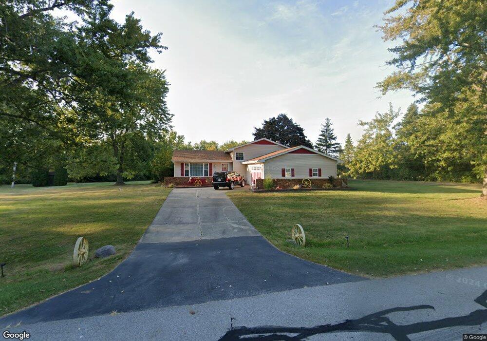
2080 W 172nd Ln Lowell, IN 46356
Cedar Creek NeighborhoodEstimated Value: $340,000 - $402,000
3
Beds
2
Baths
1,966
Sq Ft
$190/Sq Ft
Est. Value
About This Home
This home is located at 2080 W 172nd Ln, Lowell, IN 46356 and is currently estimated at $372,919, approximately $189 per square foot. 2080 W 172nd Ln is a home located in Lake County with nearby schools including Lowell Middle School and Lowell Senior High School.
Ownership History
Date
Name
Owned For
Owner Type
Purchase Details
Closed on
May 24, 2017
Sold by
Beecham Larie E
Bought by
Beecham Larie E and Hardman Linda Dawn
Current Estimated Value
Purchase Details
Closed on
Nov 1, 2016
Sold by
Beecham Larie E and Hardman Linda Dawn
Bought by
Beecham Larie E
Purchase Details
Closed on
Sep 8, 2015
Sold by
Beecham Larie E and Beecham Larry
Bought by
Beecham Larie E and Hardman Linda Dawn
Purchase Details
Closed on
May 28, 2015
Sold by
Beechem Linda Gayle
Bought by
Beecham Larry
Purchase Details
Closed on
Aug 12, 2005
Sold by
Stevens Dennis W and Stevens Judith C
Bought by
Beecham Larry and Beecham Linda Gayle
Home Financials for this Owner
Home Financials are based on the most recent Mortgage that was taken out on this home.
Original Mortgage
$118,000
Interest Rate
7.3%
Mortgage Type
Fannie Mae Freddie Mac
Create a Home Valuation Report for This Property
The Home Valuation Report is an in-depth analysis detailing your home's value as well as a comparison with similar homes in the area
Home Values in the Area
Average Home Value in this Area
Purchase History
| Date | Buyer | Sale Price | Title Company |
|---|---|---|---|
| Beecham Larie E | -- | None Available | |
| Beecham Larie E | -- | None Available | |
| Beecham Larie E | -- | None Available | |
| Beecham Larry | -- | Attorney | |
| Beecham Larry | -- | Ticor |
Source: Public Records
Mortgage History
| Date | Status | Borrower | Loan Amount |
|---|---|---|---|
| Previous Owner | Beecham Larry | $118,000 |
Source: Public Records
Tax History Compared to Growth
Tax History
| Year | Tax Paid | Tax Assessment Tax Assessment Total Assessment is a certain percentage of the fair market value that is determined by local assessors to be the total taxable value of land and additions on the property. | Land | Improvement |
|---|---|---|---|---|
| 2024 | $5,904 | $309,400 | $75,900 | $233,500 |
| 2023 | $2,532 | $305,400 | $65,400 | $240,000 |
| 2022 | $2,532 | $265,700 | $55,000 | $210,700 |
| 2021 | $1,907 | $216,900 | $50,100 | $166,800 |
| 2020 | $1,816 | $213,100 | $50,100 | $163,000 |
| 2019 | $1,869 | $206,000 | $50,100 | $155,900 |
| 2018 | $1,793 | $198,900 | $50,100 | $148,800 |
| 2017 | $1,841 | $192,200 | $44,400 | $147,800 |
| 2016 | $1,868 | $199,200 | $44,400 | $154,800 |
| 2014 | $1,778 | $190,000 | $44,400 | $145,600 |
| 2013 | $1,801 | $187,300 | $44,400 | $142,900 |
Source: Public Records
Map
Nearby Homes
- 18621 Lancer St
- 18624 Lancer St
- 18576 Lancer St
- 18644 Lancer St
- 18649 Lancer St
- 18632 Lancer St
- 18609 Lancer St
- 2104 W 181st Ave
- 16459 Grant St
- 16819 Holtz Rd
- 17020 Holtz Rd
- 16255 Grant St
- 16489 Harrison St
- 3719 167th Ave
- 2907 Approx 181st Ave
- 17781 Hillside Dr
- 3818 167th Ave
- 16655 Noble St
- 16617 Noble St
- 17793 Hillside Dr
- 2080 W 172nd Ln
- 2030 W 172nd Ln
- 2090 W 172nd Ln
- 2053 W 172nd Ave
- 2053 W 172nd Ln
- 2001 W 172nd Ln
- 1990 W 172nd Ln
- 2137 W 172nd Ln
- 1925 W 172nd Ln
- 17209 Mckinley St
- 1940 W 173rd Place
- 1920 W 172nd Ln
- 1920 W 173rd Place
- 17310 Cleveland St
- 1869 W 172nd Ln
- 1870 W 172nd Ln
- 17340 Cleveland St
- 1901 W 171st Ct
- 1868 W 173rd Place
- 17221 Roosevelt Place