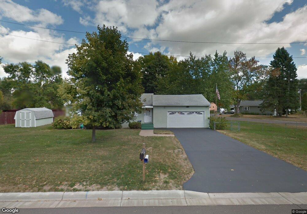
2082 Duluth St Saint Paul, MN 55109
Sherwood Glen NeighborhoodEstimated Value: $271,223 - $326,000
3
Beds
1
Bath
936
Sq Ft
$321/Sq Ft
Est. Value
About This Home
This home is located at 2082 Duluth St, Saint Paul, MN 55109 and is currently estimated at $300,306, approximately $320 per square foot. 2082 Duluth St is a home located in Ramsey County with nearby schools including Weaver Elementary School, John Glenn Middle School, and St Jerome Elementary School.
Ownership History
Date
Name
Owned For
Owner Type
Purchase Details
Closed on
May 17, 2019
Sold by
Johnson Pamela J
Bought by
Wiatros Andrew
Current Estimated Value
Home Financials for this Owner
Home Financials are based on the most recent Mortgage that was taken out on this home.
Original Mortgage
$214,310
Outstanding Balance
$188,422
Interest Rate
4.2%
Mortgage Type
New Conventional
Estimated Equity
$111,884
Create a Home Valuation Report for This Property
The Home Valuation Report is an in-depth analysis detailing your home's value as well as a comparison with similar homes in the area
Home Values in the Area
Average Home Value in this Area
Purchase History
| Date | Buyer | Sale Price | Title Company |
|---|---|---|---|
| Wiatros Andrew | $221,000 | Burnet Title |
Source: Public Records
Mortgage History
| Date | Status | Borrower | Loan Amount |
|---|---|---|---|
| Open | Wiatros Andrew | $214,310 |
Source: Public Records
Tax History
| Year | Tax Paid | Tax Assessment Tax Assessment Total Assessment is a certain percentage of the fair market value that is determined by local assessors to be the total taxable value of land and additions on the property. | Land | Improvement |
|---|---|---|---|---|
| 2025 | $3,578 | $263,200 | $57,600 | $205,600 |
| 2023 | $3,578 | $262,800 | $57,600 | $205,200 |
| 2022 | $3,150 | $253,900 | $57,600 | $196,300 |
| 2021 | $2,842 | $224,500 | $57,600 | $166,900 |
| 2020 | $2,904 | $209,300 | $57,600 | $151,700 |
| 2019 | $2,564 | $200,500 | $57,600 | $142,900 |
| 2018 | $2,442 | $182,800 | $57,600 | $125,200 |
| 2017 | $2,350 | $171,400 | $57,600 | $113,800 |
| 2016 | $2,118 | $0 | $0 | $0 |
| 2015 | $2,248 | $147,500 | $52,800 | $94,700 |
| 2014 | $1,746 | $0 | $0 | $0 |
Source: Public Records
Map
Nearby Homes
- 1290 Belmont Ln E
- 1200 Leland Rd E
- 2022 English St
- 1083 Gordon Ave
- 1800 Edward St
- 1855 Birmingham St
- 2125 Hazelwood St
- 1745 Duluth St
- 1764 English St
- 1461 Grandview Ave E
- 1984 Prosperity Rd
- TBD Eldridge Ave E
- 1894 Maryknoll Ave N
- 1633 Etna St
- 1664 Barclay St
- 1544 Duluth St
- 1563 Clarence St
- 2457 Dianna Ln
- 1561 Clarence St
- 1571 Christie Place
- 1207 Belmont Ln E
- 2092 Duluth St
- 2085 Duluth St
- 2079 Duluth St
- 1213 Belmont Ln E
- 1200 Belmont Ln E
- 1206 Belmont Ln E
- 2091 Duluth St
- 2071 Duluth St
- 1210 Belmont Ln E
- 2108 Atlantic St
- 1216 Belmont Ln E
- 2099 Duluth St
- 2065 Duluth St
- 1219 Belmont Ln E
- 2058 Duluth St
- 2114 Atlantic St
- 1220 Belmont Ln E
- 2105 Duluth St
- 2057 Duluth St
Your Personal Tour Guide
Ask me questions while you tour the home.