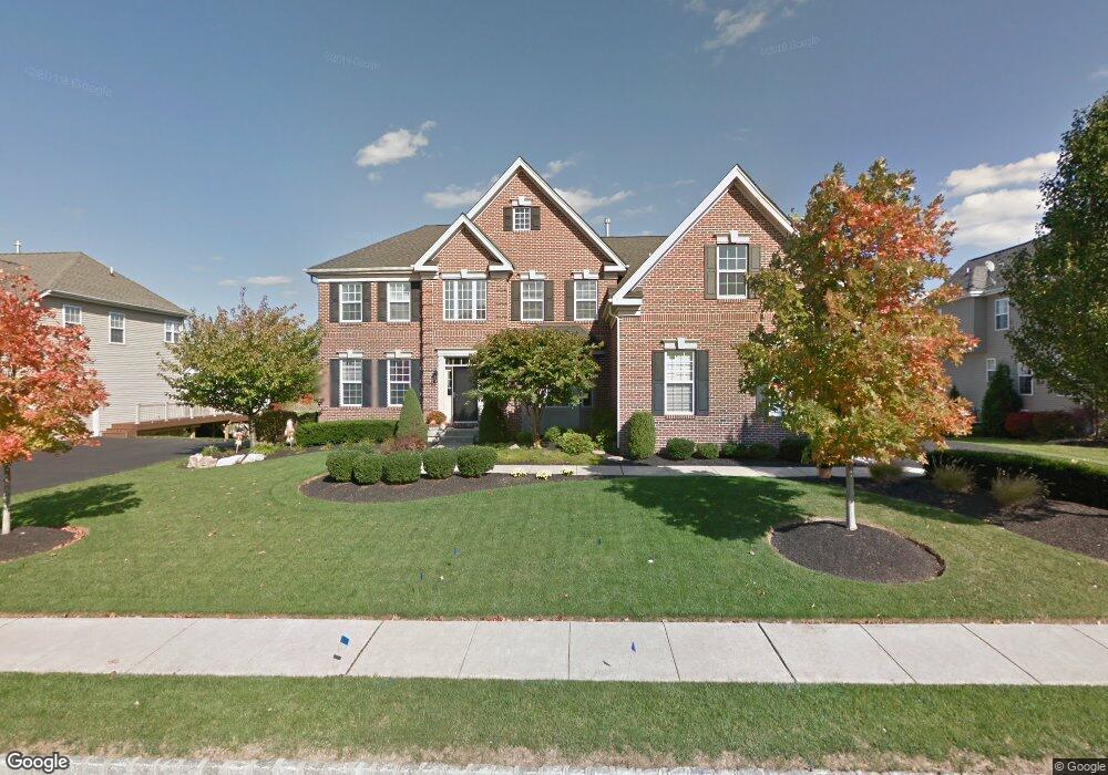
2083 Buckinghamshire Rd Furlong, PA 18925
Estimated Value: $1,025,000 - $1,113,000
4
Beds
4
Baths
3,761
Sq Ft
$288/Sq Ft
Est. Value
About This Home
This home is located at 2083 Buckinghamshire Rd, Furlong, PA 18925 and is currently estimated at $1,082,907, approximately $287 per square foot. 2083 Buckinghamshire Rd is a home located in Bucks County with nearby schools including Bridge Valley Elementary School, Holicong Middle School, and Central Bucks High School - East.
Ownership History
Date
Name
Owned For
Owner Type
Purchase Details
Closed on
Jul 11, 2007
Sold by
Gronow David S and Gronow Krista R
Bought by
Perrault Kyle M and Perrault Anita M
Current Estimated Value
Home Financials for this Owner
Home Financials are based on the most recent Mortgage that was taken out on this home.
Original Mortgage
$550,000
Interest Rate
6.74%
Mortgage Type
Purchase Money Mortgage
Purchase Details
Closed on
Jul 30, 2004
Sold by
Orleans Corp
Bought by
Gronow David S and Gronow Krista R
Home Financials for this Owner
Home Financials are based on the most recent Mortgage that was taken out on this home.
Original Mortgage
$450,000
Interest Rate
3.87%
Mortgage Type
Purchase Money Mortgage
Create a Home Valuation Report for This Property
The Home Valuation Report is an in-depth analysis detailing your home's value as well as a comparison with similar homes in the area
Home Values in the Area
Average Home Value in this Area
Purchase History
| Date | Buyer | Sale Price | Title Company |
|---|---|---|---|
| Perrault Kyle M | $728,500 | None Available | |
| Gronow David S | $617,300 | -- |
Source: Public Records
Mortgage History
| Date | Status | Borrower | Loan Amount |
|---|---|---|---|
| Previous Owner | Perrault Kyle M | $550,000 | |
| Previous Owner | Gronow David S | $450,000 | |
| Closed | Gronow David S | $25,000 |
Source: Public Records
Tax History Compared to Growth
Tax History
| Year | Tax Paid | Tax Assessment Tax Assessment Total Assessment is a certain percentage of the fair market value that is determined by local assessors to be the total taxable value of land and additions on the property. | Land | Improvement |
|---|---|---|---|---|
| 2025 | $10,361 | $63,640 | $10,520 | $53,120 |
| 2024 | $10,361 | $63,640 | $10,520 | $53,120 |
| 2023 | $10,010 | $63,640 | $10,520 | $53,120 |
| 2022 | $9,890 | $63,640 | $10,520 | $53,120 |
| 2021 | $9,772 | $63,640 | $10,520 | $53,120 |
| 2020 | $9,772 | $63,640 | $10,520 | $53,120 |
| 2019 | $9,708 | $63,640 | $10,520 | $53,120 |
| 2018 | $9,708 | $63,640 | $10,520 | $53,120 |
| 2017 | $9,629 | $63,640 | $10,520 | $53,120 |
| 2016 | $9,724 | $63,640 | $10,520 | $53,120 |
| 2015 | -- | $63,640 | $10,520 | $53,120 |
| 2014 | -- | $61,720 | $10,520 | $51,200 |
Source: Public Records
Map
Nearby Homes
- 2080 Bedfordshire Rd
- 2209 Swamp Rd
- 0 Old York Rd Unit PABU2103356
- 3657 Powder Horn Dr
- 1948 Forest Grove Rd
- 3772 Powder Horn Dr
- 3017 Dorchester St E Unit 125
- 2310 S Whittmore St
- 2113 Redbud Ln
- lot #3 next to 3739 York Rd
- 2443 Sugar Bottom Rd
- 106 Saddle Dr
- 547 Mccarty Dr
- 2479 Wheatfield Ln
- 4549 Lower Mountain Rd
- 2807 Mountain Laurel Dr
- 108 Eagle Ct Unit 105
- 1515 Sugar Bottom Rd
- 3889 Robin Rd
- 1249 Pebble Hill Rd
- 2091 Buckinghamshire Rd
- 2075 Buckinghamshire Rd
- 2099 Buckinghamshire Rd
- 2096 Bedfordshire Rd
- 2088 Bedfordshire Rd
- 2104 Bedfordshire Rd
- 2125 Bedfordshire Rd
- 2067 Buckinghamshire Rd
- 2117 Bedfordshire Rd
- 2072 Bedfordshire Rd
- 2109 Bedfordshire Rd
- 2099 Brookshire Rd
- 2091 Brookshire Rd
- 2107 Brookshire Rd
- 2083 Brookshire Rd
- 2064 Bedfordshire Rd
- 2097 Bedfordshire Rd
- 2089 Bedfordshire Rd
- 2101 Bedfordshire Rd
- 2081 Bedfordshire Rd