
Seller's Agent in 2025
Wojtek Borowski
Pearce Real Estate
(203) 606-9898
8 in this area
204 Total Sales

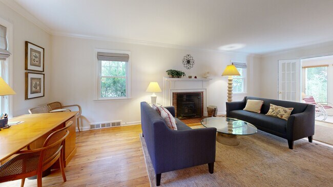


Charming and well-updated 3-bedroom, 1.1-bathroom home in the heart of Westville! This inviting residence features a spacious living room with a wood-burning fireplace and wall of built-in shelves, a sun-filled family/sun room just off the living area, and a delightful formal dining room. The updated kitchen features southwest-facing windows that bring in beautiful natural light. Upstairs, you'll find a large primary bedroom with a generous closet, two additional well-sized bedrooms, and a remodeled full bath with convenient in-unit washer and dryer. The open, unfinished walkout basement offers great potential and direct access to the backyard. Additional highlights include central air, replacement windows, a 1-car garage, and an unbeatable location-just a short walk to Hopkins School.
Last Agent to Sell the Property
Pearce Real Estate License #REB.0758965 Listed on: 07/22/2025
| Date | Type | Sale Price | Title Company |
|---|---|---|---|
| Warranty Deed | $507,000 | -- | |
| Warranty Deed | $310,000 | -- | |
| Warranty Deed | $310,000 | -- | |
| Warranty Deed | $200,000 | -- | |
| Warranty Deed | $200,000 | -- | |
| Warranty Deed | $125,000 | -- | |
| Warranty Deed | $125,000 | -- |
| Date | Status | Loan Amount | Loan Type |
|---|---|---|---|
| Open | $354,900 | New Conventional | |
| Previous Owner | $88,500 | No Value Available | |
| Previous Owner | $90,000 | Purchase Money Mortgage |
| Date | Event | Price | List to Sale | Price per Sq Ft |
|---|---|---|---|---|
| 08/27/2025 08/27/25 | Sold | $507,000 | +13.9% | $325 / Sq Ft |
| 07/22/2025 07/22/25 | For Sale | $445,000 | -- | $285 / Sq Ft |
| Year | Tax Paid | Tax Assessment Tax Assessment Total Assessment is a certain percentage of the fair market value that is determined by local assessors to be the total taxable value of land and additions on the property. | Land | Improvement |
|---|---|---|---|---|
| 2025 | $7,841 | $199,010 | $71,400 | $127,610 |
| 2024 | $7,662 | $199,010 | $71,400 | $127,610 |
| 2023 | $7,403 | $199,010 | $71,400 | $127,610 |
| 2022 | $7,911 | $199,010 | $71,400 | $127,610 |
| 2021 | $6,868 | $156,520 | $55,720 | $100,800 |
| 2020 | $6,868 | $156,520 | $55,720 | $100,800 |
| 2019 | $6,727 | $156,520 | $55,720 | $100,800 |
| 2018 | $6,727 | $156,520 | $55,720 | $100,800 |
| 2017 | $6,054 | $156,520 | $55,720 | $100,800 |
| 2016 | $6,797 | $163,590 | $65,940 | $97,650 |
| 2015 | $6,797 | $163,590 | $65,940 | $97,650 |
| 2014 | $6,797 | $163,590 | $65,940 | $97,650 |
Seller's Agent in 2025
Wojtek Borowski
Pearce Real Estate
(203) 606-9898
8 in this area
204 Total Sales
Buyer's Agent in 2025
Katherine Smith
Berkshire Hathaway Home Services
(203) 996-1712
1 in this area
75 Total Sales
Source: SmartMLS
MLS Number: 24110043
APN: NHVN-000382-001084-000900
Disclaimer: Certain information contained herein is derived from information provided by parties other than Homes.com. All information provided is deemed reliable, but is not guaranteed to be accurate and should be independently verified.
![]() IDX information is provided exclusively for personal, non-commercial use, and may not be used for any purpose other than to identify prospective properties consumers may be interested in purchasing. Information is deemed reliable but not guaranteed.
IDX information is provided exclusively for personal, non-commercial use, and may not be used for any purpose other than to identify prospective properties consumers may be interested in purchasing. Information is deemed reliable but not guaranteed.