Estimated Value: $144,869 - $182,000
3
Beds
1
Bath
904
Sq Ft
$181/Sq Ft
Est. Value
About This Home
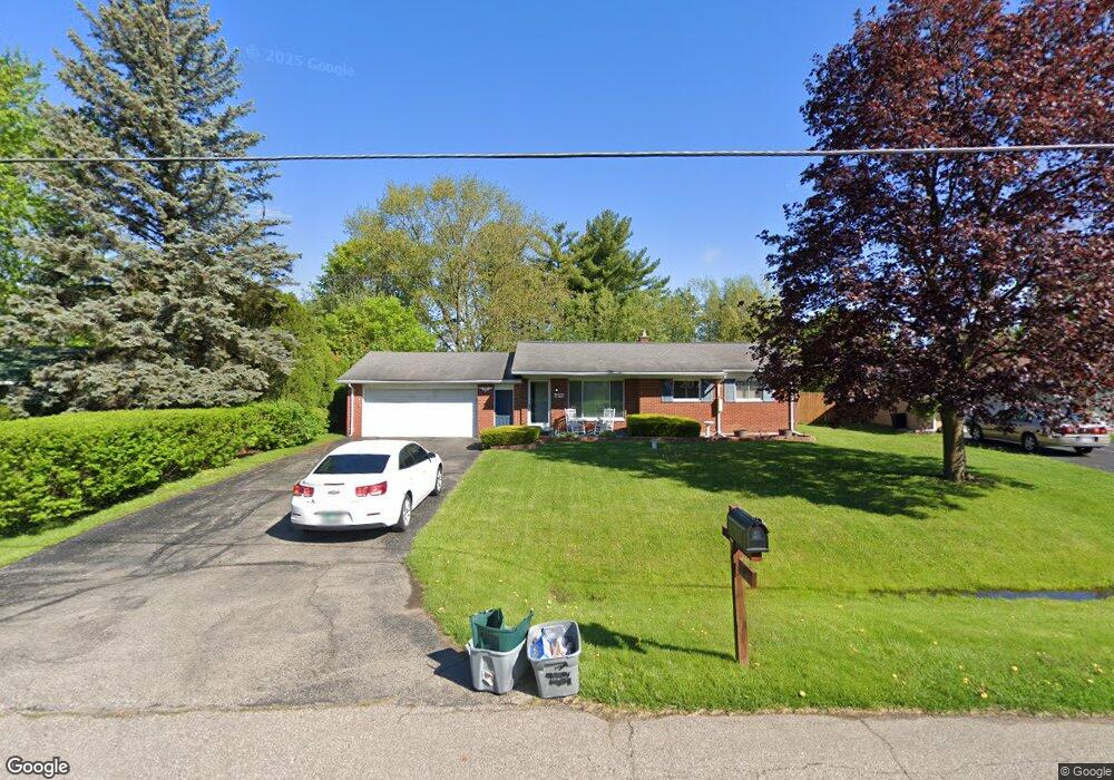
This home is located at 2086 Huntington Ave, Flint, MI 48507 and is currently estimated at $163,217, approximately $180 per square foot. 2086 Huntington Ave is a home located in Genesee County with nearby schools including Carman-Ainsworth High School and Madison Academy - Elementary School.
Ownership History
Date
Name
Owned For
Owner Type
Purchase Details
Closed on
Jun 15, 2011
Sold by
Federal National Mortgage Association
Bought by
Tigner Julie
Current Estimated Value
Purchase Details
Closed on
Aug 11, 2010
Sold by
Wynn Andrew S
Bought by
Federal National Mortgage Association
Purchase Details
Closed on
May 4, 2006
Sold by
Eggert Patricia L
Bought by
Wynn Andrew S
Home Financials for this Owner
Home Financials are based on the most recent Mortgage that was taken out on this home.
Original Mortgage
$98,400
Interest Rate
6.54%
Mortgage Type
Fannie Mae Freddie Mac
Create a Home Valuation Report for This Property
The Home Valuation Report is an in-depth analysis detailing your home's value as well as a comparison with similar homes in the area
Home Values in the Area
Average Home Value in this Area
Purchase History
| Date | Buyer | Sale Price | Title Company |
|---|---|---|---|
| Tigner Julie | $47,000 | Etitle Agency Inc | |
| Federal National Mortgage Association | $100,144 | None Available | |
| Wynn Andrew S | $123,000 | Multiple |
Source: Public Records
Mortgage History
| Date | Status | Borrower | Loan Amount |
|---|---|---|---|
| Previous Owner | Wynn Andrew S | $98,400 |
Source: Public Records
Tax History
| Year | Tax Paid | Tax Assessment Tax Assessment Total Assessment is a certain percentage of the fair market value that is determined by local assessors to be the total taxable value of land and additions on the property. | Land | Improvement |
|---|---|---|---|---|
| 2025 | $2,101 | $57,300 | $0 | $0 |
| 2024 | $1,047 | $56,400 | $0 | $0 |
| 2023 | $1,103 | $51,300 | $0 | $0 |
| 2022 | $931 | $45,000 | $0 | $0 |
| 2021 | $1,440 | $39,300 | $0 | $0 |
| 2020 | $863 | $35,800 | $0 | $0 |
| 2019 | $854 | $32,800 | $0 | $0 |
| 2018 | $1,682 | $32,300 | $0 | $0 |
| 2017 | $1,846 | $32,300 | $0 | $0 |
| 2016 | $1,676 | $29,900 | $0 | $0 |
| 2015 | $1,066 | $27,800 | $0 | $0 |
| 2014 | $633 | $26,700 | $0 | $0 |
| 2012 | -- | $27,000 | $27,000 | $0 |
Source: Public Records
Map
Nearby Homes
- 2029 Gerard St
- 2190 W Maple Ave
- 2077 Kingswood Dr
- G4203 van Slyke Rd
- 1489 Maria St
- 4139 Moulton Dr
- 1151 Bristol Rd
- 4267 Torrey Rd
- 1203 Pickwick Place
- 1508 W Bristol Rd
- 5366 van Slyke Rd
- 1449 Sunset Blvd
- 3485 Hammerberg Rd
- 5131 Gateway Centre Blvd
- 1097 W Buder Ave
- 1446 Stephens Ave
- 1119 W Bergin Ave
- 1051 W Mclean Ave
- 1121 W Boatfield Ave
- 1085 W Parkwood Ave
- 2092 Huntington Ave
- 2080 Huntington Ave
- 2072 Huntington Ave
- 4417 Old Colony Dr
- 2102 Huntington Ave
- 2083 Huntington Ave
- 4409 Old Colony Dr
- 4400 Gerard Ct
- 2073 Huntington Ave
- 2097 Huntington Ave
- 4394 Gerard Ct
- 2064 Huntington Ave
- 4388 Gerard Ct
- 4406 Gerard Ct
- 4401 Old Colony Dr
- 4452 Westmont Dr
- 4438 Woodbriar Dr
- 4453 Westmont Dr
- 2056 Huntington Ave
- 2105 Huntington Ave
Your Personal Tour Guide
Ask me questions while you tour the home.