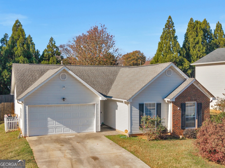
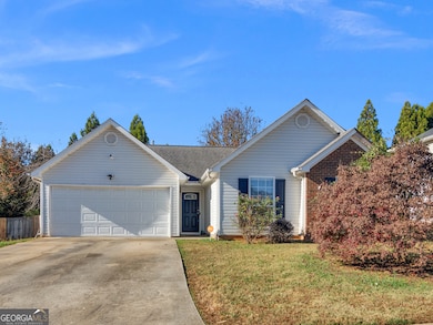
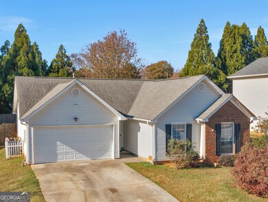

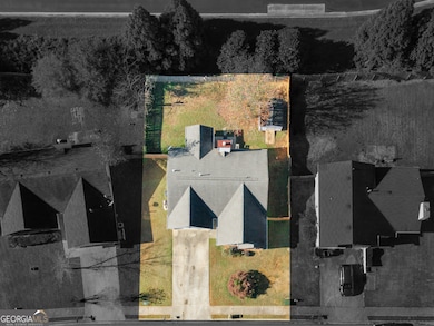

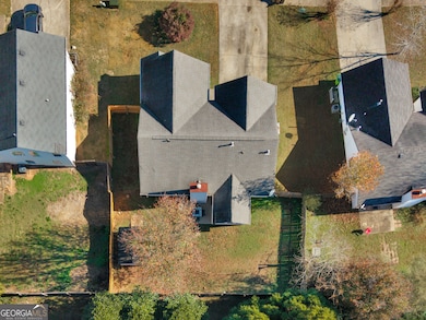
209 Brannans Walk McDonough, GA 30253
Estimated payment $1,739/month
Highlights
- Ranch Style House
- 1 Fireplace
- No HOA
- Union Grove High School Rated A
- Bonus Room
- Walk-In Pantry
About This Home
Holiday Special!! Sellers are offering a $3500 credit with a full price offer- use it toward closing cost OR toward paint and cosmetic updates so you can pick your own style and make this home yours! Welcome to 209 Brannans Walk located in McDonough, Georgia. A home that perfectly balances lasting quality with modern comfort. Thoughtfully cared for and updated over the years, this residence offers its next owner the rare combination of character, reliability, and move-in readiness. You'll immediately appreciate the welcoming curb appeal, mature landscaping, and the quiet street-side setting that still keeps you close to shopping, dining, and the best of McDonough living. Inside, the home opens into generous living spaces, comfortable for everyday life yet ideal for hosting friends and family. The kitchen is a true highlight, featuring beautiful quartz countertops, a stylish tile backsplash, and a walk-in pantry - a perfect blend of elegance and function. The primary suite continues the theme of comfort with a large walk-in closet and plenty of space to unwind. For added peace of mind, the home includes a brand-new HVAC system and a new water heater, both equipped with warranties, offering durability and long-term confidence for the next owner. The garage has been closed in, providing additional flexible space that can be used for storage, hobbies, or future living area, complete with its own closet for extra convenience while still allowing the future homeowner the option to revert it back to a full garage if preferred. Out back, the fenced-in yard serves as a private retreat - a wonderful family space where countless cherished memories have been made. Natural light fills the home, the layout flows effortlessly, and every detail reflects a sense of care and pride. 209 Brannans Walk offers the confidence of well-kept systems, the charm of a mature neighborhood, and the comfort of a home ready for its next chapter. If you're looking for lasting value and everyday ease, this is it.
Home Details
Home Type
- Single Family
Est. Annual Taxes
- $3,985
Year Built
- Built in 1997
Lot Details
- 7,405 Sq Ft Lot
- Privacy Fence
- Fenced
- Level Lot
Home Design
- Ranch Style House
- Tar and Gravel Roof
- Vinyl Siding
Interior Spaces
- 1,387 Sq Ft Home
- 1 Fireplace
- Family Room
- Bonus Room
- Pull Down Stairs to Attic
- Fire and Smoke Detector
- Laundry in Kitchen
Kitchen
- Walk-In Pantry
- Built-In Oven
- Dishwasher
Flooring
- Carpet
- Tile
Bedrooms and Bathrooms
- 3 Main Level Bedrooms
- Walk-In Closet
- 2 Full Bathrooms
Parking
- 4 Parking Spaces
- Parking Pad
Outdoor Features
- Shed
Schools
- Hickory Flat Elementary School
- Union Grove Middle School
- Union Grove High School
Utilities
- Central Air
- Heating System Uses Natural Gas
- Cable TV Available
Community Details
- No Home Owners Association
- Brannans Walk Subdivision
Map
Home Values in the Area
Average Home Value in this Area
Tax History
| Year | Tax Paid | Tax Assessment Tax Assessment Total Assessment is a certain percentage of the fair market value that is determined by local assessors to be the total taxable value of land and additions on the property. | Land | Improvement |
|---|---|---|---|---|
| 2025 | $3,338 | $102,720 | $12,000 | $90,720 |
| 2024 | $3,338 | $101,040 | $12,000 | $89,040 |
| 2023 | $2,743 | $97,400 | $10,000 | $87,400 |
| 2022 | $2,455 | $76,040 | $10,000 | $66,040 |
| 2021 | $2,052 | $59,000 | $10,000 | $49,000 |
| 2020 | $1,912 | $53,080 | $8,000 | $45,080 |
| 2019 | $1,761 | $49,720 | $8,000 | $41,720 |
| 2018 | $1,732 | $48,480 | $8,000 | $40,480 |
| 2016 | $1,551 | $43,240 | $8,000 | $35,240 |
| 2015 | $1,443 | $39,640 | $8,000 | $31,640 |
| 2014 | $1,356 | $37,160 | $8,000 | $29,160 |
Property History
| Date | Event | Price | List to Sale | Price per Sq Ft |
|---|---|---|---|---|
| 11/25/2025 11/25/25 | Price Changed | $267,500 | -1.3% | $193 / Sq Ft |
| 11/12/2025 11/12/25 | Price Changed | $270,900 | -1.5% | $195 / Sq Ft |
| 11/04/2025 11/04/25 | Price Changed | $274,900 | -1.8% | $198 / Sq Ft |
| 10/30/2025 10/30/25 | For Sale | $279,900 | -- | $202 / Sq Ft |
Purchase History
| Date | Type | Sale Price | Title Company |
|---|---|---|---|
| Deed | $129,200 | -- | |
| Deed | $95,900 | -- |
Mortgage History
| Date | Status | Loan Amount | Loan Type |
|---|---|---|---|
| Open | $128,111 | FHA | |
| Previous Owner | $93,000 | New Conventional |
Source: Georgia MLS
MLS Number: 10632781
APN: 070D-01-003-000
Disclaimer: Certain information contained herein is derived from information provided by parties other than Homes.com. All information provided is deemed reliable, but is not guaranteed to be accurate and should be independently verified.
![]() The data relating to real estate for sale on this web site comes in part from the Broker Reciprocity Program of Georgia MLS. Real estate listings held by brokerage firms other than Redfin are marked with the Broker Reciprocity logo and detailed information about them includes the name of the listing brokers. Information deemed reliable but not guaranteed. Copyright 2025 Georgia MLS. All rights reserved.
The data relating to real estate for sale on this web site comes in part from the Broker Reciprocity Program of Georgia MLS. Real estate listings held by brokerage firms other than Redfin are marked with the Broker Reciprocity logo and detailed information about them includes the name of the listing brokers. Information deemed reliable but not guaranteed. Copyright 2025 Georgia MLS. All rights reserved.
- 248 Brannans Walk
- 153 Rockport Dr
- 214 Kensington Trace
- 228 Kensington Trace
- 152 Rockport Dr
- 796 Rock Ln
- 200 Kensington Trace
- 401 Crosshaven Way
- 733 Stonehaven Chase
- 601 Sawgrass Walk
- 212 Himalaya Way
- 248 Cranapple Ln
- 146 Himalaya Way
- 236 Himalaya Way
- 104 Riverside Close
- 418 Abbey Springs Way
- 479 Crosshaven Way
- 805 Cog Hill
- 441 Aviemore Loop
- 1008 Carlyle Place
- 232 Brannans Walk
- 796 Rock Ln
- 1900 Waterford Landing
- 1154 Paramount Dr
- 236 Windy Cir
- 209 Braemar Ct Unit MAIN LEVEL (1A)
- 209 Braemar Ct Unit BASEMENT APARTMENT
- 209 Braemar Ct Unit 2
- 209 Braemar Ct Unit 1
- 644 Aspen Brook Dr
- 517 Cascade Walk
- 402 Grandiflora Dr
- 224 Mckinley Loop
- 197 Weldon Rd
- 334 Sound Cir
- 145 Weldon Rd
- 105 Peach Pointe Dr
- 310 Sound Cir
- 344 Langshire Dr
- 839 Taurus Dr
