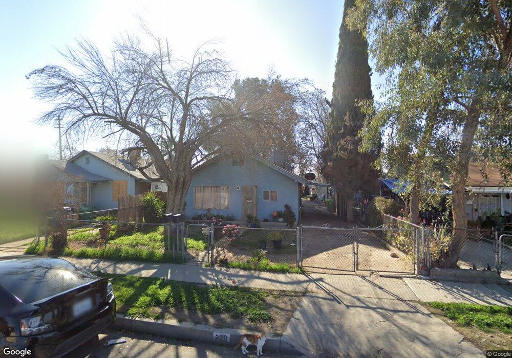
209 Lincoln Ave Bakersfield, CA 93308
Estimated Value: $185,708 - $210,000
2
Beds
1
Bath
906
Sq Ft
$217/Sq Ft
Est. Value
About This Home
This home is located at 209 Lincoln Ave, Bakersfield, CA 93308 and is currently estimated at $196,677, approximately $217 per square foot. 209 Lincoln Ave is a home located in Kern County with nearby schools including Standard Elementary School, Standard Middle School, and North High School.
Ownership History
Date
Name
Owned For
Owner Type
Purchase Details
Closed on
Aug 24, 2023
Sold by
Sanchez Pablo and Sanchez Olga Lidia
Bought by
Sanchez Olga Lidia and Sanchez Maxx Uriel
Current Estimated Value
Purchase Details
Closed on
Apr 5, 1994
Sold by
Barton Emily J
Bought by
Sanchez Pablo and Sanchez Olga Lidia
Home Financials for this Owner
Home Financials are based on the most recent Mortgage that was taken out on this home.
Original Mortgage
$43,000
Interest Rate
7.15%
Mortgage Type
Seller Take Back
Create a Home Valuation Report for This Property
The Home Valuation Report is an in-depth analysis detailing your home's value as well as a comparison with similar homes in the area
Home Values in the Area
Average Home Value in this Area
Purchase History
| Date | Buyer | Sale Price | Title Company |
|---|---|---|---|
| Sanchez Olga Lidia | -- | None Listed On Document | |
| Sanchez Pablo | -- | -- |
Source: Public Records
Mortgage History
| Date | Status | Borrower | Loan Amount |
|---|---|---|---|
| Previous Owner | Sanchez Pablo | $43,000 |
Source: Public Records
Tax History Compared to Growth
Tax History
| Year | Tax Paid | Tax Assessment Tax Assessment Total Assessment is a certain percentage of the fair market value that is determined by local assessors to be the total taxable value of land and additions on the property. | Land | Improvement |
|---|---|---|---|---|
| 2025 | $1,856 | $73,048 | $25,476 | $47,572 |
| 2024 | $1,787 | $71,617 | $24,977 | $46,640 |
| 2023 | $1,787 | $70,214 | $24,488 | $45,726 |
| 2022 | $1,708 | $68,838 | $24,008 | $44,830 |
| 2021 | $1,616 | $67,489 | $23,538 | $43,951 |
| 2020 | $1,543 | $66,798 | $23,297 | $43,501 |
| 2019 | $1,523 | $66,798 | $23,297 | $43,501 |
| 2018 | $1,468 | $64,207 | $22,394 | $41,813 |
| 2017 | $1,451 | $62,949 | $21,955 | $40,994 |
| 2016 | $1,353 | $61,716 | $21,525 | $40,191 |
| 2015 | $1,315 | $59,000 | $15,000 | $44,000 |
| 2014 | $1,144 | $45,000 | $11,000 | $34,000 |
Source: Public Records
Map
Nearby Homes
- 217 Decatur St
- 229 Washington Ave
- 115 Decatur St
- 302 Washington Ave
- 304 Washington Ave
- 306 Washington Ave
- 308 Washington Ave
- 324 Lincoln Ave
- 111 Warren Ave
- 112 Woodrow Ave
- 304 Woodrow Ave
- 110 Cooper Ave
- 710 N Chester Ave
- 301 Harding Ave
- 109 Hughes Ave
- 311 Wilson Ave
- 407 Washington Ave
- 115 Ferguson Ave
- 118 Hughes Ave
- 114 E Warren Ave
- 207 Lincoln Ave
- 211 Lincoln Ave
- 205 Lincoln Ave Unit A-B
- 205 Lincoln Ave
- 213 Lincoln Ave
- 215 Lincoln Ave
- 805 California St
- 201 Lincoln Ave
- 202 1/2 Decatur St
- 203 Lincoln Ave
- 202 Decatur St
- 204 Decatur St
- 204 1/2 Decatur St
- 217 Lincoln Ave
- 206 Decatur St
- 208 Lincoln Ave
- 200 Decatur St
- 208 Decatur St
- 219 Lincoln Ave
- 212 Lincoln Ave