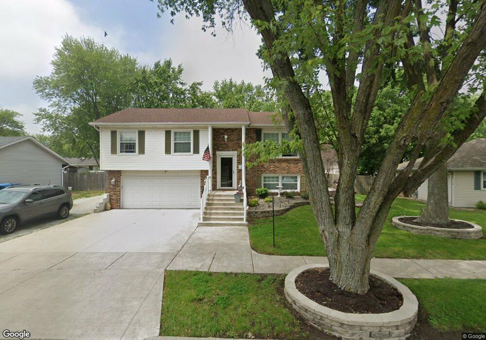
209 Meadows Rd S Bourbonnais, IL 60914
Estimated Value: $256,622 - $286,000
4
Beds
2
Baths
1,677
Sq Ft
$163/Sq Ft
Est. Value
About This Home
This home is located at 209 Meadows Rd S, Bourbonnais, IL 60914 and is currently estimated at $274,156, approximately $163 per square foot. 209 Meadows Rd S is a home located in Kankakee County with nearby schools including Shabbona Elementary School, Liberty Intermediate School, and Bourbonnais Upper Grade Center.
Ownership History
Date
Name
Owned For
Owner Type
Purchase Details
Closed on
Apr 23, 2018
Sold by
Patrevito Mark A
Bought by
White Robert C and White Rose L
Current Estimated Value
Home Financials for this Owner
Home Financials are based on the most recent Mortgage that was taken out on this home.
Original Mortgage
$165,280
Outstanding Balance
$142,681
Interest Rate
4.88%
Mortgage Type
VA
Estimated Equity
$131,475
Create a Home Valuation Report for This Property
The Home Valuation Report is an in-depth analysis detailing your home's value as well as a comparison with similar homes in the area
Home Values in the Area
Average Home Value in this Area
Purchase History
| Date | Buyer | Sale Price | Title Company |
|---|---|---|---|
| White Robert C | $160,000 | Godin Denton & Elliott Pc |
Source: Public Records
Mortgage History
| Date | Status | Borrower | Loan Amount |
|---|---|---|---|
| Open | White Robert C | $165,280 |
Source: Public Records
Tax History
| Year | Tax Paid | Tax Assessment Tax Assessment Total Assessment is a certain percentage of the fair market value that is determined by local assessors to be the total taxable value of land and additions on the property. | Land | Improvement |
|---|---|---|---|---|
| 2024 | $4,942 | $70,673 | $6,562 | $64,111 |
| 2023 | $4,478 | $65,438 | $6,076 | $59,362 |
| 2022 | $4,186 | $59,833 | $5,856 | $53,977 |
| 2021 | $3,881 | $56,002 | $5,727 | $50,275 |
| 2020 | $3,574 | $51,638 | $5,574 | $46,064 |
| 2019 | $3,401 | $49,257 | $5,412 | $43,845 |
| 2018 | $3,409 | $47,682 | $5,332 | $42,350 |
| 2017 | $3,637 | $46,519 | $5,202 | $41,317 |
| 2016 | $3,532 | $45,428 | $5,125 | $40,303 |
| 2015 | $3,500 | $44,583 | $5,074 | $39,509 |
| 2014 | $3,361 | $44,583 | $5,074 | $39,509 |
| 2013 | -- | $46,579 | $5,074 | $41,505 |
Source: Public Records
Map
Nearby Homes
- 206 Meadows Rd S
- 273 Harvard Ave
- 1063 Yale Ave
- 214 Greenbriar Ln
- 530 Meadows Rd S
- 9 Hilltop Dr
- 42 Hanson Dr
- 22 Emery Dr
- 16 Kim Dr
- Lot 5 Larry Power Rd
- 59 Hanson Dr
- 180 Karen Dr
- 899 Armour Rd
- 1565 Stefanie Ln
- 675 Washington Ave
- 54 Bonds Dr
- 172 Anita Dr
- 287 Belle Aire Ave
- 250 N Levasseur Ave
- 703 Heritage Dr
- 213 Meadows Rd S
- 205 Meadows Rd S
- 217 Meadows Rd S
- 214 Harvard Ave
- 210 Harvard Ave
- 218 Harvard Ave
- 210 Meadows Rd S
- 206 Harvard Ave
- 222 Harvard Ave
- 202 Harvard Ave
- 221 Meadows Rd S
- 202 Meadows Rd S
- 226 Harvard Ave
- 101 N Edgemere Dr
- 214 Meadows Rd S
- 102 N Edgemere Dr
- 225 Meadows Rd S
- 230 Harvard Ave
- 229 Harvard Ave
- 237 Harvard Ave
Your Personal Tour Guide
Ask me questions while you tour the home.