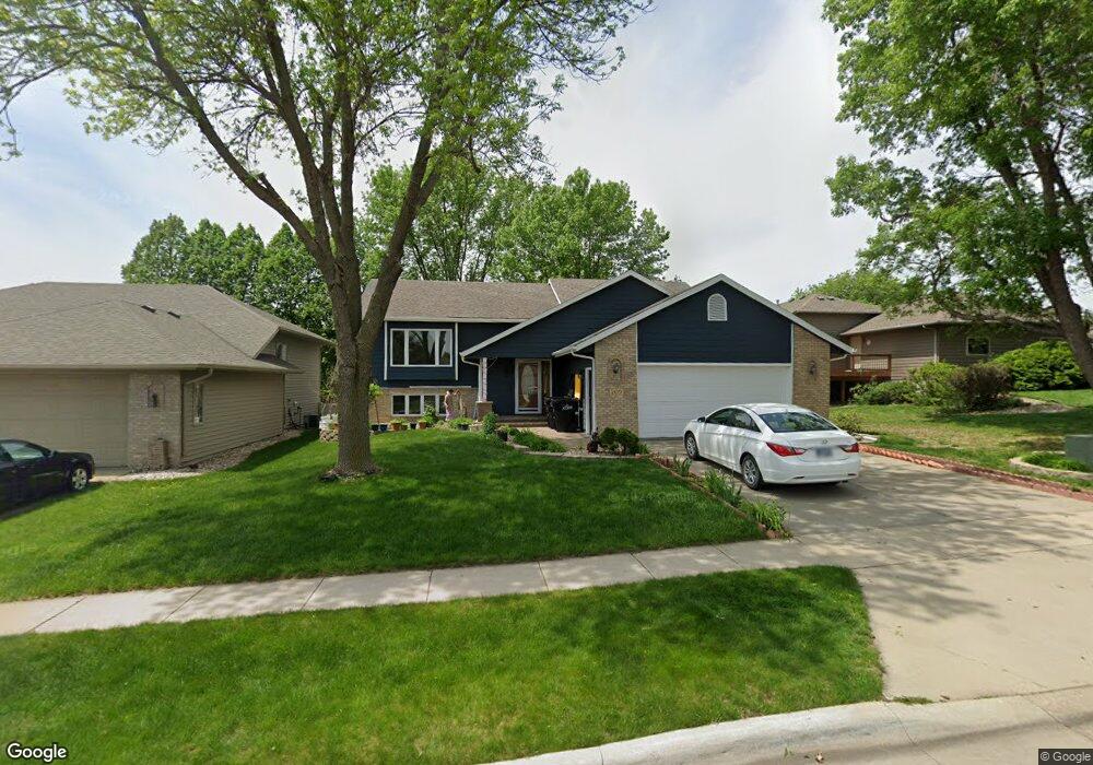
209 N La Salle Ave Sioux Falls, SD 57110
Northeast Sioux Falls NeighborhoodEstimated Value: $376,000 - $424,000
5
Beds
3
Baths
2,342
Sq Ft
$170/Sq Ft
Est. Value
About This Home
This home is located at 209 N La Salle Ave, Sioux Falls, SD 57110 and is currently estimated at $397,344, approximately $169 per square foot. 209 N La Salle Ave is a home located in Minnehaha County with nearby schools including Rosa Parks Elementary School, Washington High School, and Sioux Falls Christian Elementary School.
Ownership History
Date
Name
Owned For
Owner Type
Purchase Details
Closed on
Mar 5, 2014
Sold by
Alan R Alan R and White Linda L
Bought by
Beeson Ronald K and Beeson Lindsay A
Current Estimated Value
Home Financials for this Owner
Home Financials are based on the most recent Mortgage that was taken out on this home.
Original Mortgage
$209,597
Outstanding Balance
$158,565
Interest Rate
4.29%
Mortgage Type
VA
Estimated Equity
$238,779
Create a Home Valuation Report for This Property
The Home Valuation Report is an in-depth analysis detailing your home's value as well as a comparison with similar homes in the area
Home Values in the Area
Average Home Value in this Area
Purchase History
| Date | Buyer | Sale Price | Title Company |
|---|---|---|---|
| Beeson Ronald K | $206,650 | Getty Abstract & Title Comp |
Source: Public Records
Mortgage History
| Date | Status | Borrower | Loan Amount |
|---|---|---|---|
| Open | Beeson Ronald K | $209,597 |
Source: Public Records
Tax History Compared to Growth
Tax History
| Year | Tax Paid | Tax Assessment Tax Assessment Total Assessment is a certain percentage of the fair market value that is determined by local assessors to be the total taxable value of land and additions on the property. | Land | Improvement |
|---|---|---|---|---|
| 2024 | $4,670 | $346,400 | $29,200 | $317,200 |
| 2023 | $4,630 | $330,800 | $29,200 | $301,600 |
| 2022 | $4,563 | $307,600 | $29,200 | $278,400 |
| 2021 | $3,830 | $258,300 | $0 | $0 |
| 2020 | $3,830 | $247,100 | $0 | $0 |
| 2019 | $3,807 | $241,333 | $0 | $0 |
| 2018 | $3,423 | $230,799 | $0 | $0 |
| 2017 | $3,315 | $217,743 | $28,785 | $188,958 |
| 2016 | $3,315 | $210,872 | $28,785 | $182,087 |
| 2015 | $3,045 | $194,745 | $28,614 | $166,131 |
| 2014 | $2,962 | $185,708 | $28,614 | $157,094 |
Source: Public Records
Map
Nearby Homes
- 119 N La Salle Cir
- 120 N Detroit Ave
- 305 N Marquette Ave
- 800 802 N Marquette Ave
- 707 709 N Marquette Ave
- 4835 E Hanover Cir
- 5201 E Quincey St
- 108 S Sycamore Ave
- 4800 Grant St
- 200 S Dewberry Cir
- 101 S Foss Ave
- 813 N Marquette Ave
- 316 N Holiday Ave
- 4912 E Brennan Dr
- 608 N Dubuque Ave
- 4509 -4515 E 3rd st St
- 401 N Meyer Ln
- 600 S Charlotte Ave
- 4620 E 3rd St Unit 9
- 4721 E 3rd St
- 205 N La Salle Ave
- 4809 E Adams St
- 201 N La Salle Ave
- 4801 E Adams St
- 212 N Detroit Ave
- 200 N La Salle Ave
- 208 N La Salle Ave
- 208 N Detroit Ave
- 129 N La Salle Ave
- 204 N Detroit Ave
- 212 N La Salle Ave
- 301 N La Salle Ave
- 200 N Detroit Ave
- 125 N La Salle Cir
- 125 N La Salle Cir Cir
- 207 N Penstemon Ave
- 300 N La Salle Ave
- 215 N Penstemon Ave
- 219 N Penstemon Ave
- 305 N La Salle Ave