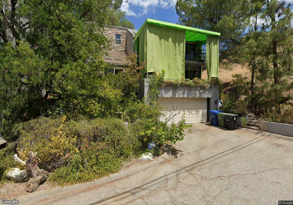
20901 Abalar St Woodland Hills, CA 91364
Estimated Value: $1,187,415 - $1,474,000
3
Beds
3
Baths
2,778
Sq Ft
$484/Sq Ft
Est. Value
About This Home
This home is located at 20901 Abalar St, Woodland Hills, CA 91364 and is currently estimated at $1,343,854, approximately $483 per square foot. 20901 Abalar St is a home located in Los Angeles County with nearby schools including Woodland Hills Academy, Serrania Charter For Enriched Studies, and Woodland Hills Elementary Charter For Enriched Studies.
Ownership History
Date
Name
Owned For
Owner Type
Purchase Details
Closed on
Feb 11, 2011
Sold by
Kramer Michael and Moline Bobbie
Bought by
Kramer Michael and Moline Bobbie
Current Estimated Value
Purchase Details
Closed on
Dec 14, 1993
Sold by
Kramer Michael S and Moline Bobbie
Bought by
Kramer Michael S and Moline Bobbie D
Home Financials for this Owner
Home Financials are based on the most recent Mortgage that was taken out on this home.
Original Mortgage
$220,000
Interest Rate
7.2%
Create a Home Valuation Report for This Property
The Home Valuation Report is an in-depth analysis detailing your home's value as well as a comparison with similar homes in the area
Home Values in the Area
Average Home Value in this Area
Purchase History
| Date | Buyer | Sale Price | Title Company |
|---|---|---|---|
| Kramer Michael | -- | None Available | |
| Kramer Michael S | -- | Stewart Title |
Source: Public Records
Mortgage History
| Date | Status | Borrower | Loan Amount |
|---|---|---|---|
| Previous Owner | Kramer Michael S | $220,000 |
Source: Public Records
Tax History Compared to Growth
Tax History
| Year | Tax Paid | Tax Assessment Tax Assessment Total Assessment is a certain percentage of the fair market value that is determined by local assessors to be the total taxable value of land and additions on the property. | Land | Improvement |
|---|---|---|---|---|
| 2025 | $7,471 | $609,859 | $187,640 | $422,219 |
| 2024 | $7,471 | $597,902 | $183,961 | $413,941 |
| 2023 | $7,329 | $586,179 | $180,354 | $405,825 |
| 2022 | $7,010 | $574,686 | $176,818 | $397,868 |
| 2021 | $6,912 | $563,418 | $173,351 | $390,067 |
| 2019 | $6,706 | $546,709 | $168,210 | $378,499 |
| 2018 | $6,658 | $535,990 | $164,912 | $371,078 |
| 2016 | $6,328 | $515,178 | $158,509 | $356,669 |
| 2015 | $6,236 | $507,441 | $156,129 | $351,312 |
| 2014 | $6,260 | $497,502 | $153,071 | $344,431 |
Source: Public Records
Map
Nearby Homes
- 20967 Bandera St
- 4742 Bedel St
- 0 Elzevir Rd & Morro Dr Rd
- 4218 Morro Dr
- 4707 Bedel St
- 20927 Calimali Rd
- 4356 Tosca Rd
- 20906 Almazan Rd
- 4698 Morro Dr
- 21090 Rios St
- 4322 Rosario Rd
- 20620 Chatsboro Dr
- 20608 Chatsboro Dr
- 4608 Westchester Dr
- 4264 Rosario Rd
- 4256 Rosario Rd
- 4319 Saltillo St
- 4377 Saltillo St
- 4305 Saltillo St
- 4751 Westchester Dr
- 20905 Abalar St
- 20911 Abalar St
- 20908 Abalar St
- 20910 Bandera St
- 20905 Pilar Rd
- 20919 Abalar St
- 20916 Abalar St
- 20900 Bandera St
- 20934 Bandera St
- 4398 Morro Dr
- 20938 Bandera St
- 4392 Morro Dr
- 20908 Bandera St
- 20923 Abalar St
- 20914 Pilar Rd
- 20916 Bandera St
- 20944 Bandera St
- 20903 Puente Rd
- 4401 Morro Dr
- 20948 Bandera St