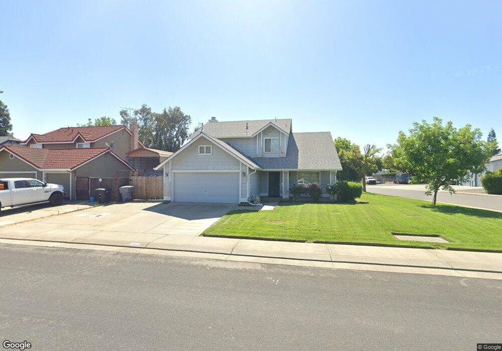
2095 Swanson Dr Escalon, CA 95320
Estimated Value: $516,320 - $578,000
3
Beds
3
Baths
1,874
Sq Ft
$289/Sq Ft
Est. Value
About This Home
This home is located at 2095 Swanson Dr, Escalon, CA 95320 and is currently estimated at $541,580, approximately $288 per square foot. 2095 Swanson Dr is a home located in San Joaquin County with nearby schools including Dent Elementary School, El Portal Middle School, and Escalon High School.
Ownership History
Date
Name
Owned For
Owner Type
Purchase Details
Closed on
Sep 25, 2000
Sold by
Woodward Charles M and Woodward Almeda A
Bought by
Flores Michael and Flores Josephine
Current Estimated Value
Home Financials for this Owner
Home Financials are based on the most recent Mortgage that was taken out on this home.
Original Mortgage
$178,500
Outstanding Balance
$65,376
Interest Rate
7.98%
Mortgage Type
VA
Estimated Equity
$476,204
Create a Home Valuation Report for This Property
The Home Valuation Report is an in-depth analysis detailing your home's value as well as a comparison with similar homes in the area
Home Values in the Area
Average Home Value in this Area
Purchase History
| Date | Buyer | Sale Price | Title Company |
|---|---|---|---|
| Flores Michael | $175,000 | Alliance Title Company |
Source: Public Records
Mortgage History
| Date | Status | Borrower | Loan Amount |
|---|---|---|---|
| Open | Flores Michael | $178,500 |
Source: Public Records
Tax History Compared to Growth
Tax History
| Year | Tax Paid | Tax Assessment Tax Assessment Total Assessment is a certain percentage of the fair market value that is determined by local assessors to be the total taxable value of land and additions on the property. | Land | Improvement |
|---|---|---|---|---|
| 2025 | $2,978 | $263,675 | $82,868 | $180,807 |
| 2024 | $2,889 | $258,506 | $81,244 | $177,262 |
| 2023 | $2,840 | $253,438 | $79,651 | $173,787 |
| 2022 | $2,730 | $248,470 | $78,090 | $170,380 |
| 2021 | $2,759 | $243,599 | $76,559 | $167,040 |
| 2020 | $2,734 | $241,102 | $75,774 | $165,328 |
| 2019 | $2,694 | $236,376 | $74,289 | $162,087 |
| 2018 | $2,663 | $231,742 | $72,833 | $158,909 |
| 2017 | $2,594 | $227,199 | $71,405 | $155,794 |
| 2016 | $2,558 | $222,746 | $70,006 | $152,740 |
| 2014 | $2,469 | $215,104 | $67,604 | $147,500 |
Source: Public Records
Map
Nearby Homes
- 1525 Crestwood Dr
- 1970 Mchenry Ave
- 1534 Oakwood Dr
- 1518 Glenwood Ct
- 1521 Deborah Cir
- 1510 Deborah Cir
- 1724 Countrywood Ln
- 19149 Saint John Rd
- 1778 Judith Way
- 1855 Coley Ave
- 2226 Edmart St
- 1647 Jerry Ave
- 0 James St
- 0 Jackson Unit 224004642
- 1506 Mitchell Ave
- 812 California St
- 2505 Jackson Ave Unit 207
- 2505 Jackson Ave Unit 179
- 2505 Jackson Ave Unit 132
- 2505 Jackson Ave Unit 107
- 2101 Swanson Dr
- 2083 Swanson Dr
- 2107 Swanson Dr
- 2077 Swanson Dr
- 1507 Ullrey Ave
- 1500 Ullrey Ave
- 2113 Swanson Dr
- 1506 Oakwood Dr
- 2400 Mchenry Ave
- 1506 Ullrey Ave
- 1513 Ullrey Ave
- 2071 Swanson Dr
- 2119 Swanson Dr
- 1501 Crestwood Dr
- 1501 Oakwood Dr
- 1512 Oakwood Dr
- 1512 Ullrey Ave
- 1507 Crestwood Dr
- 1519 Ullrey Ave
- 2065 Swanson Dr